|
The
Mulberry Harbours, Normandy France.
A Great WW2 Engineering
Achievement
Background
The 'Mulberry Harbours' was a WW2 civil
engineering project of immense size and complexity. The floating harbours provided
port facilities during the invasion of Normandy from June 1944
until French ports like Cherbourg were captured. How did they erect two
harbours, each the size of Dover, in just a few days in wartime, when Dover
itself took
7 years?
When
it came to ousting the Germans from their entrenched defensive positions
along the 'Atlantic Wall,' planners knew that blockading and attack by air
would not be sufficient. The Germans would defend their
 front lines with
great vigour and only an overwhelming large scale invasion force, with their equipment and supplies, would be up to
the task. front lines with
great vigour and only an overwhelming large scale invasion force, with their equipment and supplies, would be up to
the task.
[Photo; Aerial view of a completed
Mulberry Harbour with its main component parts identified.]
In the crucial days
and weeks following the landing, the Allies could ill afford delays in
supplying their advancing forces. Intelligence reports indicated that
French seaports were heavily defended by German forces and
they were liable to be disabled in the event of imminent Allied occupation.
Planners also drew on the main lesson learnt from the ill-fated
Dieppe Raid, that heavily defended ports could not be taken without crippling
losses. What could be done to provide harbour
facilities close to the landing beaches, where none existed? They'd take their
own!
Conventional construction of a harbour would require detailed ground and seabed surveys,
precise building and engineering plans, several years construction time and a
large, highly skilled labour force to build it. Any new harbours would need to
be construct in days, by a competent labour force, under
the guidance of skilled engineers and all within range of enemy aircraft and
long range guns.
The
Concept
In 1917, Churchill drafted detailed
plans for the capture of two islands, Borkum and Sylt, which lay off the Dutch
and Danish coasts. He envisaged using flat-bottomed barges, or
caissons, measuring 37m x 23m x 12m, which would form the basis of an artificial
harbour when lowered to the seabed and filled with sand. Events moved on and
Churchill's proposal was quietly forgotten.
In 1941, Hugh Iorys Hughes, a
quiet, unassuming Welshman from North Wales, had similar ideas. He was a
successful civil engineer living in London, when he submitted plans to the War
Office. Their potential value was not immediately recognised but Hughes'
brother, a Commander in the Royal Navy, drew the plan to the attention of more
senior officers. It was the beginning of a long association Hughes had with the Mulberry project.
Other accounts credit Professor J
D Bernal with similar ideas, expanded upon by Brigadier Bruce White, who later
helped draw up plans for the final design of Mulberry. He was greatly
assisted by Allan Beckett whose "whale" design for the roadway was selected in
preference to Hamilton's Swiss Roll and Hughes' concrete Hippo (more information
on these
below). With a project of this size and complexity, it's no surprise that there were
a number of major players in
the Mulberry story. Both Bruce White and Allan Beckett wrote papers
about aspects of Mulberry, details of which can be found at the bottom of this
page under Reading Material & Websites.
Preparations
Early in 1941, a new department
within the War Office was formed, code named 'Transportation 5' (Tn5) under
Major General D J McMullen. It had responsibility for port engineering, repairs
and maintenance. Under the command of civil engineer, Bruce White, their
 first
project was to construct two military ports in the Clyde estuary, one of which
was in Gare
Loch. However, the Mulberry project and the construction of embarkation points on the shores of the UK,
soon became its top priority. first
project was to construct two military ports in the Clyde estuary, one of which
was in Gare
Loch. However, the Mulberry project and the construction of embarkation points on the shores of the UK,
soon became its top priority.
[Photos; a pair of stranded caissons
in Portland Harbour still dominating the skyline after 70 years (2013) and a
view of them from the air.
Copyright 2016
Google & Digital Globe.]
There was much debate with the
Americans about how best to provide sheltered harbours. Ideas including sunken ships,
concrete caissons, concrete pontoons, collapsible canvas floating barriers and
Pykrete were considered. There was, unsurprisingly, scepticism on both sides
of the Atlantic with some believing that Mulberry was an even more fanciful idea than Pykrete
ships! To
overcome the doubters in his ranks, Mountbatten called a meeting in
one of the bathrooms of the Queen Mary. They were en route to an important
meeting with the Americans in Quebec, where a decision on artificial harbours
would be taken.
 As they entered the bathroom, they saw a partially filled
bath, 40 or so ships made out of newspaper and a Mae West lifebelt. Half the 'fleet' was placed in the
bath and the most junior officer present in the crowded bathroom, Lt Commander
Grant, RN, was asked to make waves with the back of a brush. In no time, the
vessels sank. The demonstration was repeated this time with the 'fleet' floating
inside the Mae West. To the immortal command "More waves please, Lieutenant
Grant" the heavily braided onlookers saw that all the vessels survived. As they entered the bathroom, they saw a partially filled
bath, 40 or so ships made out of newspaper and a Mae West lifebelt. Half the 'fleet' was placed in the
bath and the most junior officer present in the crowded bathroom, Lt Commander
Grant, RN, was asked to make waves with the back of a brush. In no time, the
vessels sank. The demonstration was repeated this time with the 'fleet' floating
inside the Mae West. To the immortal command "More waves please, Lieutenant
Grant" the heavily braided onlookers saw that all the vessels survived.
One USA sceptic, Admiral John
Leslie Hall Junior, US Navy Commander, was not convinced. He predicted that
the Mulberries would never stand up to the rigours of the English Channel and
questioned the need for harbours, since he could unload 1000 LSTs at a time on
open beaches... more than enough to supply the advancing Allied forces. His
prediction was, at least in part, later proved to be correct in the case of
Mulberry A (details below) but the balance of opinion was in favour the
project and it was approved. The task was given to Mountbatten's Combined Operations
but on realising that the resources needed were beyond his
Command's capacity, he contracted out the operational aspects to the War Department.
The
Prototypes
Three designs were selected for
further evaluation. The first, from the War Office, was for flexible steel bridges
on pontoons of steel or concrete with pier-head units on adjustable legs to rise
and fall on the tides. The second, from the Admiralty, was a flexible floating
construction of timber and canvas held together with steel cables, similar in
appearance to a 'Swiss Roll' in its stored condition. The third, from Iorys
Hughes, envisaged the use of steel bridges to be mounted on concrete caissons and
floated to the sites and sunk in position. Initially, none of the proposals
envisaged the need for breakwaters protection.
 In
the search for flat, sandy beaches with characteristics similar to those
of Normandy, the remote and sparsely populated area around Wigtown Bay on
the Scottish side of the Solway Firth proved ideal after exhaustive beach
and sea bed surveys. Its remote location ensured that an
effective security cordon could be set up. In
the search for flat, sandy beaches with characteristics similar to those
of Normandy, the remote and sparsely populated area around Wigtown Bay on
the Scottish side of the Solway Firth proved ideal after exhaustive beach
and sea bed surveys. Its remote location ensured that an
effective security cordon could be set up.
[Map of
South West Scotland courtesy of
Google Map Data 2017.]
The whole area from Garlieston to the Isle of Whithorn (not an
island!) was declared off limits to all except local fishermen. Work
started on the construction of a military camp at Cairnhead to accommodate
the increasing numbers of engineering sappers, with an
additional 200 men being accommodated in the village hall in Garlieston.
The
prototypes were constructed at "the Morfa," Conwy in North Wales, where over 1000
local and outside workers were drafted in for the purpose. One such was Olef
Kerensky, the son of a former Russian Prime Minister, who supervised the
construction process. With his mother, he fled from Leningrad at the age of 10
and entered the UK on a false passport! Raymond Lee was a small boy when he
witnessed the construction of the massive caissons from his home on the other
side of the Conwy estuary.
 The Morfa area was transformed
into a huge construction site. Hughes' three 'Hippo' caissons were towed to
the site in Rigg Bay near Garlieston. Two 'Croc' roadways were attached to the
metal bars on the Hippos and various combinations were tested in a variety of
weather and tidal conditions. Fully laden vehicles were driven across the
roadway. The Morfa area was transformed
into a huge construction site. Hughes' three 'Hippo' caissons were towed to
the site in Rigg Bay near Garlieston. Two 'Croc' roadways were attached to the
metal bars on the Hippos and various combinations were tested in a variety of
weather and tidal conditions. Fully laden vehicles were driven across the
roadway.
[Map of North Wales courtesy of
Google Map Data 2017.]
The testing allowed the engineers to assess the characteristics of the components
and the whole assembly. It was found that
the floating piers did not rise and fall with the tide as predicted but Hughes
found a solution in the provision of adjustable spans between the Hippos and the
roadway. A more serious problem was the unexpected pitching and yawing of the
Hippos, causing the attached Croc roadways to buckle. Hughes proposed the
construction of Hippos of diminishing size, on which the roadways would sit.
Hughes' design was not alone in
experiencing problems. When Hamilton's Swiss Roll roadway was tested with a 3
ton tipper truck, the roadway sank in under two hours. Adjustments were made, but
further tests in the open sea confirmed that its load bearing capacity of 7
tons, fell well short of what was required to carry a tank. The
Swiss Roll roadway design was soon abandoned. It was Beckett's
flexible bridging units, supported on pontoons, which produced the best results.
However,
Churchill was not happy with the rate of progress. He had sent a memo to
Mountbatten on the 30th May 1942... "Piers for use on beaches. They
must float up and down with the tide. The anchor problem must be mastered. Let
me have the best solution worked out. Don't argue the matter. The difficulties
will argue for themselves." Progress at first was slow, as the merits of
complex, competing, cutting edge proposals were championed by the many interested parties. Churchill's
frustration was very evident from the
 content of increasingly irate messages he
penned in the following months, culminating in this one
of 10 Mar 1943. "This matter is being much
neglected. Dilatory experiments with varying types and patterns have resulted in
us having nothing. It is now nearly six months
since I urged the construction of several miles of pier." content of increasingly irate messages he
penned in the following months, culminating in this one
of 10 Mar 1943. "This matter is being much
neglected. Dilatory experiments with varying types and patterns have resulted in
us having nothing. It is now nearly six months
since I urged the construction of several miles of pier."
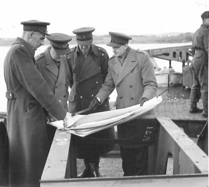
[Photo; Major Carline, The
Quarter Master General, Sir Riddle-Webster, Brig. Bruce-White and Maj
Steer-Webster examining plans at Garlieston Harbour. © IWM H 28097.]
Organisational changes were made
to "get a grip" on the project. There were tensions between the War Office and
the Admiralty, causing poor co-operation and bad communications. After earlier
allocations of responsibility had failed to resolve matters, the War Office was
tasked to design the caissons and oversee the development of the pier-heads and
piers, while the Admiralty were tasked to design and oversee the development of
the floating breakwaters. This arrangement was later refined to accommodate
Admiralty concerns about the berthing and navigation guides, by giving them
responsibility for towing all the components across the channel, the layout and
positioning of the harbours and the navigational channels and moorings.
While the early designs did not envisage
protective breakwaters, it became clear that an area of calmer water was
essential. The final plans would use the traditional breakwaters but other calming measures
were considered, including "bubble breaker" and "lilo". The former involved pumping high pressure air along perforated pipelines, causing
a large volume of compressible air in the sea, which was sufficient to absorb the power of
heavy breakers. The latter comprised large canvas bags extending some 4m below the
waves and 3m above. They were inflated to low pressure and operated on a similar
basis to the bubble breaker, in that they would absorb the power of the waves by
allowing the air they contained to be compressed.
On conclusion of the tests a
final design was chosen. There would be two harbours, each comprising two
breakwaters, offshore and flanking, made from hollow ferro-concrete caissons. To
provide extra protection, 70 obsolete merchant and navy 'block-ships'
would be sunk to fill gaps in the protection provided by the caissons. Inside
the protective cordons, pier-heads connected to the
shore by Beckett's floating steel roadways, would complete the harbours.
Churchill recruited Iorys Hughes as a consultant to the project, because
of his commitment and expertise.
Final Specification
 The
ideal specification was a pier a mile long, capable of withstanding gale
force winds and berthing large coasters. To do this, the
artificial harbours would need to provide sheltered conditions and be
larger than the port of Dover, which had taken seven years to build. Within the sheltered areas, stable floating quays would be
located some distance from the beaches to provide sufficient water depth
(6.7 metres) for the docking vessels. These quays would be linked to the
beaches by floating roadways, to allow the discharged goods and equipment
to be transported ashore in fleets of lorries. Two harbours would be
required - Mulberry A for the USA beaches of Omaha and Utah and Mulberry B
for the British and Canadian beaches of Gold, Juno and Sword. The designs
would allow for the floating caissons to be secured in place in four days.
Each harbour would have a capacity of 7000 tons of vehicles and
supplies per day. The
ideal specification was a pier a mile long, capable of withstanding gale
force winds and berthing large coasters. To do this, the
artificial harbours would need to provide sheltered conditions and be
larger than the port of Dover, which had taken seven years to build. Within the sheltered areas, stable floating quays would be
located some distance from the beaches to provide sufficient water depth
(6.7 metres) for the docking vessels. These quays would be linked to the
beaches by floating roadways, to allow the discharged goods and equipment
to be transported ashore in fleets of lorries. Two harbours would be
required - Mulberry A for the USA beaches of Omaha and Utah and Mulberry B
for the British and Canadian beaches of Gold, Juno and Sword. The designs
would allow for the floating caissons to be secured in place in four days.
Each harbour would have a capacity of 7000 tons of vehicles and
supplies per day.
For security reasons, randomly
selected codes were used to describe the various components of the two Mulberry
Harbours viz...
Breakwaters
-
Bombardons - floating
breakwaters, comprising huge, metal, crucifix shaped structures ballasted and
firmly anchored in place. They were the outermost barrier and, therefore, the
first line of defence against rough seas.
-
Phoenixes - 146 concrete
caissons, 60 metres long, 18 metres high and 15 metres wide, making up 9.5
kilometres of the breakwater. They were airtight, floating cases open at the bottom
with air-cocks to lower them to the sea-bed in a controlled fashion. Around 2
million tons of steel and concrete were used in their construction.
-
 Gooseberries - 70
obsolete merchant vessels (block ships) were gathered together at Oban on the west coast of
Scotland, stripped down, ballasted and primed with explosive scuttling charges.
The vessels sailed under their own steam and were sunk in 5 locations, including
the 2 Mulberry harbours. Gooseberries - 70
obsolete merchant vessels (block ships) were gathered together at Oban on the west coast of
Scotland, stripped down, ballasted and primed with explosive scuttling charges.
The vessels sailed under their own steam and were sunk in 5 locations, including
the 2 Mulberry harbours.
Pierheads
-
Pierheads were
located at the seaward end of the roadways. Each stood on four legs called
'Spuds', with a platform that could be raised and lowered with the tide, using
electric winches. Twenty three were planned, of which eight were spares.
Roadways [Photo;
Mulberry roadway. © IWM (H 39295).]
-
Beetles - concrete
and steel floats or pontoons to support the roadways. Each was capable of
supporting the 56 tons of the Whales bridging pieces + 25 tons of a tank.
-
Whales - 16 kilometres of
roadways.
-
Buffer - approach span
from the floating roadway to beach.
-
Rhino - power driven
pontoon, on which cargo was brought ashore.
Intelligence
Gathering
The success
of the operation would depend on accurate and detailed topographical information
about the beaches and coastal towns along the French coast. Aerial photographs
helped identify likely locations but, to obtain more detailed views, the
Government appealed to the public for holiday photographs and postcards of
unspecified coastal areas of France. However, much more detailed information on
the target beaches and their approaches was required. Local conditions, such as
the composition of the beaches, hidden underwater banks, German defensive
obstacles, depth of water, tidal conditions, etc., would all be taken into account
in the planning of the project. The stakes were very high, since poor intelligence
could jeopardise the whole vast project and cause many deaths and injuries. There was no room for error.
On New
Year's eve 1943, under the leadership of 24 year old Major Logan Scott Bowden of
the Royal Engineers, a unit set out in motor torpedo boats to reconnoitre the
area around Luc-sur-Mer. They transferred to a hydrographical survey craft and
moved closer to shore. Major Logan and Sgt Bruce Ogden-Smith then swam to the
beaches, where they took samples of sand, mud, peat and gravel, which they stored
in labelled tubes. They were careful not to leave behind any evidence of their
visits, lest the Germans, becoming aware to their clandestine activities, might
deduce the purpose behind them. Their lateral movements along the beaches, for
example, were made below the tide mark, thus leaving no incriminating
evidence behind! Their mission
was a total success.
A month or
so later, this time using a midget submarine under tow for part of the
way, they approached the area to the west of Port-en-Bessin and Vierville. This was followed
by a similar visit to the Omaha beach area a few weeks later. From all the
information gathered, two scale models of the landing beaches were constructed.
One was held by the War Department
in room 474 of the Great Metropole Hotel in London and a duplicate in the Prime
Minister's room in the War Cabinet Offices - two of the most secret rooms in the
country.
At Cairnryan, just north of
Stranraer in south west Scotland, the information gathered about the beaches was
used to construct a full size reproduction of the beaches. This would allow
the planners to assess the effectiveness of the current landing techniques and
the movement of men and machinery over the terrain.
The Manufacturing Process
The scale
of the project was enormous and was in danger of over-stretching the capacity of
the UK's civil engineering industry. From late summer of 1943 onwards, three
hundred firms were recruited from around the country, employing 40,000 to 45,000
personnel at the peak. Men from trades and backgrounds, not associated with the
construction industry, were drafted in and given crash courses appropriate to
their work. Their task was to construct 212 caissons ranging from 1672 tons to
6044 tons, 23 pier-heads and 10 miles of floating roadway.
Most of the concrete caissons were
manufactured on the River Thames and the River Clyde, in some cases using hastily
constructed dry docks. The steel "Beetle" floats were assembled in Richborough,
Kent, the concrete Beetles at Southsea, Marchward and Southampton and the
pier-heads and buffer ramps at the Morfa site Hughes had used for the
manufacture of his Hippo caissons. Trials continued to be run in the Garlieston
area of the Solway Firth, even during the manufacturing phase of the project.
Hughes' involvement continued
throughout the manufacturing period and beyond. He helped identify Selsey and
Dungeness, on the south coast of England, as ideal places to 'park' the
completed caissons until needed. Also closely involved in the planning for D-Day
and the Mulberry Harbours, was Sir Harold Werner. He was a rather overbearing,
single minded individual, who did not court popularity or make friends amongst
his
professional contacts. Perhaps, as a consequence of this, his valuable service,
in finding solutions to insurmountable problems and generally keeping the
project on schedule, went largely unrecognised after the war.
 D-Day
+ D-Day
+
A large number of British and USA
tugs were requisitioned, for Operation Corncob, to tow the Mulberries from their assembly point, near
Lee-on-Solent, to France. They departed on June 4 but were held in mid channel
when D-Day was delayed by a day. By the time of the initial assault landings, most caissons were
positioned about 5 miles off the French coast.
Click here for information about
the British and American tugs involved.
[Map of Normandy Beaches courtesy of
Google Map Data 2017.]
Responsibility for Mulberry B, off Arromanches, fell to the No 1 Port Construction and Repair Group. They sailed
in the evening of June 6 1944 and by the early hours of June 7, under the
command of Lt Col Mais, markers were positioned at the high tide mark on the
landing beach and on higher
ground beyond. These markers would be used to align the first two piers into
their correct positions. Further out to sea, marker buoys for the caissons and
block ships were positioned in their predetermined places. Under the command of
Lt Col Landsdowne, RN, the block-ships left Poole harbour for France, on their final voyages, before
they were to be scuttled. It would be a tricky operation to achieve the 'overlapping' positions
the plan envisaged but essential to ensure protection against high seas and fast flowing
tides.
Similar operations were in
progress at Mulberry A off Vierville-Saint-Laurent but here, the vessels arrived
under heavy enemy fire. The tugs, which had accompanied the vessels and which
were to assist in their final positioning, dispersed earlier than planned but,
by a
stroke of good fortune, the 2nd and 3rd block-ships were sunk by the Germans in
roughly the correct positions.
In all, 5 Gooseberries were positioned to provide
the best protection for the two Mulberry harbours and for other beach landing
points at Utah, Courseulles, 11k east of Arromanches, and Ouistreham. The
breakwaters also provided a good measure of protection during the construction of the
2 Mulberry harbours. The UTAH beach became a major logistical supply base for the Americans up to November
'44, thanks to the protection afforded by its 'Goosberry.'
The Bombardons were towed out on
June 6 to their moorings, which had been laid previously by boom laying craft.
However, a mistaken order resulted in the Bombardons being placed in water some
20m to 24m deep, rather than the designed 13m and they were strung out in a
single line instead of the planned double line. The effectiveness of this outer
barrier was compromised.
 The
photo opposite was sent in by Scott Blyth, who wrote; On June
12, 1944, my father, Lt. John S. Blyth, flew a photo recce mission to the Loire
Bridges. It was sortie 1841 of the 14th Squadron of the 7th Photo Group (USAAF).
The targets were La Huichetiere, Nantes Airfield, Le Port Boulet Bridge damage
assessment and the Loire Bridges from Nantes to Tours. He was based at Mt Farm
near Oxford and on that mission flew Spit MK XI PA 841. Crossing the coast over
Omaha Beach, he took at least one photo of the beachhead. It appears to
contain one of the piers of Mulberry A. The
photo opposite was sent in by Scott Blyth, who wrote; On June
12, 1944, my father, Lt. John S. Blyth, flew a photo recce mission to the Loire
Bridges. It was sortie 1841 of the 14th Squadron of the 7th Photo Group (USAAF).
The targets were La Huichetiere, Nantes Airfield, Le Port Boulet Bridge damage
assessment and the Loire Bridges from Nantes to Tours. He was based at Mt Farm
near Oxford and on that mission flew Spit MK XI PA 841. Crossing the coast over
Omaha Beach, he took at least one photo of the beachhead. It appears to
contain one of the piers of Mulberry A.
The caissons had a 4 man crew, two
sailors and an anti-aircraft gun emplacement. On D+1, the caissons were towed to
positions about a mile off-shore, where a fleet of powerful harbour
tugs maneuvred them into their final positions. The caissons' sea valves were
opened, allowing them to settle on the seabed at previously agreed positions and depths. Each Mulberry was
about a mile long and stood about 30 ft (9m) above sea level at low tide and 10
ft (3m) at high tide. The block-ships at Mulberry B were in position by June
13th, forming two crescent shaped harbours, which accommodated 75 Liberty ships
and small craft.
The
installation of the 'stores' and 'LST' piers proved to be more of a problem.
The components began to arrive at Mulberry B on D+4. Work continued
throughout the night but choppy seas caused problems in manoeuvring the bridging
spans into position. However, by D+8, 1.2 kilometres of pier and roadway
were in place and operational. The 2nd stores pier was operational by July
8, however, the Beetle floats, to support the roadway, had been positioned
in an overlapping pattern, rather than opposite each other as the design
intended. This error contributed to stability problems, which were later experienced. The Luftwaffe attacked
Mulberry B on July 15 but the very strong anti aircraft defences shot down 9 of the 12 Messcherschmitts.
 Mulberry
A was in use for less than 10 days when, on June 19, it was severely damaged by
the worst period of sustained severe weather in 40 years. 21 caissons of the
original 31 were damaged beyond repair with broken backs and sides. Mulberry A was never
used again and parts of it were scavenged to repair damage to Mulberry B. Mulberry
A was in use for less than 10 days when, on June 19, it was severely damaged by
the worst period of sustained severe weather in 40 years. 21 caissons of the
original 31 were damaged beyond repair with broken backs and sides. Mulberry A was never
used again and parts of it were scavenged to repair damage to Mulberry B.
[Photo; DUKWs or "Ducks" being driven up the hillside to the unloading
point where they discharge their loads into lorries. The Mulberry harbour at
Arromanches can be seen in the background. © IWM (A 24677).]
The
Americans quickly reverted to the traditional method of unloading from beached landing
craft and DUKWs, often coming in on one tide and leaving on the next. Such was
their success that on occasions they exceeded the impressive performance of Mulberry B.
Each day, until the end of August, around 9000 tons were
landed via Mulberry B. By this time, Cherbourg port
became available for use, at least in part.
Towards the end of the
year, after the capture of
Walcheren in mid November 1944, the port of Antwerp also became available
and by then was much closer to the action, as the Allies moved closer to Germany's
borders. Mulberry B was in use for 5 months, during which time over 2 million
men, half a million vehicles and 4 million tons of supplies passed through the
harbour. During this period, several additional caissons reinforced weak points in the
breakwater.
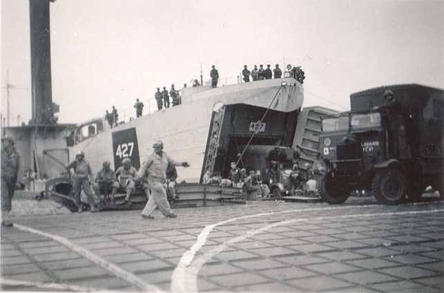
[ 4 Photos opposite and below; HMLST 427 discharging her cargo
onto Mulberry A prior to the 19th June storm.]
T he Mulberry project was a great
feat of engineering, as it challenged numerous, unique complex problems. The
manufacturing task was completed in just 6
months, by hundreds of contractors, in dozens of locations, under wartime
conditions and a serious shortage of skilled labour. he Mulberry project was a great
feat of engineering, as it challenged numerous, unique complex problems. The
manufacturing task was completed in just 6
months, by hundreds of contractors, in dozens of locations, under wartime
conditions and a serious shortage of skilled labour.
In approving the Mulberry Harbour
project, the planners paramount concern was to secure the Allied supply line,
without which invasion would stall as supplies, armaments and fuel dried up. The
enemy would then have a relatively quiet period to regroup and to draw on their
reserves. There are those who believe that Mulberry was unnecessary, as exampled
by the Americans success in landing supplies directly onto the beaches after the
abandonment of Mulberry A. We'll never know, with any degree of certainty, what
would have happened had
 Mulberry never been built... and that, for many, is
all the justification needed for the planners' decision to authorise the
project. Mulberry never been built... and that, for many, is
all the justification needed for the planners' decision to authorise the
project.
Except
in the memories of the dwindling few who were there, there
is nothing in our collective experience that allows us to fully appreciate the vastness of the operation and the absolute
necessity to move men, supplies, munitions and equipment to the right place at
the right time. Even the logistics faced by the largest supermarket chains today
pale into insignificance, when compared to the task faced by the planners in the
early 1940s. They faced an awesome responsibility with dire
consequences for the world in the event of failure to deliver.
 The
Supermarket comparison offers an
opportunity to put the scale of the task into a modern context. It has been
calculated that each serviceman needed 6.5lb (3Kg) per day to sustain him in the
field. On this basis1000 men needed around 2.5 tons, 100,000 needed 250 tons and
1,000,000 needed 2,500 tons per day! The
Supermarket comparison offers an
opportunity to put the scale of the task into a modern context. It has been
calculated that each serviceman needed 6.5lb (3Kg) per day to sustain him in the
field. On this basis1000 men needed around 2.5 tons, 100,000 needed 250 tons and
1,000,000 needed 2,500 tons per day!
As the size of the invading force grew, so
did the daily demand for supplies. In addition, there were lorries, tanks, artillery pieces,
ammunition, military field hospitals, mobile radar and communications units etc,
etc. all of which had to be transported across the channel. Over 4,000 vessels
plied the waters between the UK and Normandy from D-Day and the contribution of
Mulberry B, in speeding up the operation and securing the supply chain in adverse
weather conditions, is beyond question. The majority of vessels in use were not
capable of beach landings.
A fter the war, at the Nurembeurg
trials, Albert Speer gave the enemy perspective on the Mulberry Harbours and
their Atlantic Wall defences. 'To construct our defences we had, in two years,
used some 13 million cubic metres of concrete and 1.5 million tons of steel. A
fortnight after the landings by the enemy, this costly effort was brought to
nothing because of an idea of simple genius. As we know now, the invasion forces
brought their own harbours and built at Arromanches and Omaha, on
unprotected coast, the necessary landing ramps." fter the war, at the Nurembeurg
trials, Albert Speer gave the enemy perspective on the Mulberry Harbours and
their Atlantic Wall defences. 'To construct our defences we had, in two years,
used some 13 million cubic metres of concrete and 1.5 million tons of steel. A
fortnight after the landings by the enemy, this costly effort was brought to
nothing because of an idea of simple genius. As we know now, the invasion forces
brought their own harbours and built at Arromanches and Omaha, on
unprotected coast, the necessary landing ramps."
[Photo;
Looking east towards Arromanches courtesy of Nigel Stewart.]
Memorials
& Plaques
  Location - Conwy, North Wales. Follow signs for the marina. The plaque
is situated in the council car park next to Conwy Marina. Other Info
- read the full story about the design, testing, development and
manufacture of the Mulberry Harbours and of the key
role of a local boy cum civil engineer. Location - Conwy, North Wales. Follow signs for the marina. The plaque
is situated in the council car park next to Conwy Marina. Other Info
- read the full story about the design, testing, development and
manufacture of the Mulberry Harbours and of the key
role of a local boy cum civil engineer.
Further Reading
There are around 300 books listed on
our 'Combined Operations Books' page. They, or any
other books you know about, can be purchased on-line from the
Advanced Book Exchange (ABE). Their search banner link, on our 'Books' page, checks the shelves of
thousands of book shops world-wide. Just type in, or copy and paste the
title of your choice, or use the 'keyword' box for book suggestions.
There's no obligation to buy, no registration and no passwords.
Memoirs of a Concrete Consultant by Victor S Wigmore. The author was a consulting engineer on the
Mulberry Harbour project in the SE of England. His speciality was in the use
of concrete. Chapter VII of his book describes aspects of his work on
Mulberry. Pub in 1979 by New Horizon, 5, Victoria Drive, Bognor Regis, West
Sussex. ISBN 0 86116 127 0.
A Harbour Goes to War -
The Story of Mulberry and The
Men Who Made it Happen by Jane Evans, E. Palmer & R. Walter. The Mulberry harbours were a vital link in the
supply chain following the Normandy invasion. This is the story of
their development in Scotland, and their use, using personal anecdotes
and photographs.
ISBN
1873547307.
Force Mulberry by Alfred Stanford. The Planning & Installation of the artificial
harbor off U.S. Normandy Beaches. William Morrow and Co, 1951.
Conwy
Mulberry
Harbour by Mark Hughes. Paperback, ISBN 0-86381-757-2.
Code Name Mulberry by G Hartcup. The Planning, Building and Operation of the
Normandy Harbors Published 1977 David & Charles, London & Hippocrene Books
Inc NY.
Some
(engineering)
Aspects of the Design of Flexible Bridging, Including 'Whale'
Floating Roadways
by the engineer/designer Allan Beckett. Available
as PDF download.
Untold Stories of D-Day
- National Geographical June 2002.
Detailed account
of
Mulberry B
including tables of the movement of men and materials through the completed
harbour.
Thames Tugs.
Click here for archive
information about the British and American Tugs used to transport/tow the Mulberry Harbours
across the English Channel.
Correspondence
Mulberry Mobile Cranes
 Hello Geoff, Hello Geoff,
I don't know if this information is of interest to
you but I recently discovered that Jones Cranes of Letchworth provided cranes
for unloading ships at the Mulberry harbours. My
mother, who lived in East Ham at the time, was a
seamstress for a well known manufacturer of wedding dresses and was conscripted
as a welder and found herself building cranes in Letchworth!
According to the Jones
website,
this photo opposite is one
of the KL 15 mobile cranes in action unloading a barge
at Arromanches.
I also discovered that Allan Beckett,
whose "whale" design for the roadway was selected in
preference to other designs, was an
old boy of my school, East Ham Grammar, so I have a personal interest in the
Mulberry harbours! My mother, by the way, was a
classmate of Vera Lynn's and although they never kept in touch, I actually found
myself in contact with the great lady this summer, a sprightly 101 year old.
Best wishes,
Alan Davidge
Mulberry Harbour Models
Hello Geoff,
I attach a pdf of my Grandfather's wartime involvement in model making
including the Mulberry Harbour model.
MULBERRY HARBOUR MODEL.pdf
Regards
Stephen Masters
Garlieston Today.
I'm a retired Territorial Army Major and have an
interest in military history. My uncle was involved in the building of the
Mulberry Harbours during the Second World War and since I live just a few miles
from the location of the top secret trials mentioned above, I have a special
interest in the subject. With the eye of a retired Chartered Surveyor, I inspected the remains of the Mulberry Harbours
in France and also the location of the various works at
Garlieston. A study of the information contained within the display and exhibition at Garlieston
and on the Combined Operations website added to my field research.
Until recent times very few local people talked about the Mulberry trials which must have had a big impact on
such a small community. They were certainly capable of keeping a secret!
The village today comprises a small port on the
east coast of The Machars in the former county of Wigtownshire. Its origins date
back to the 1780s when Lord Garlies planned and built a small port on the
sheltered shores of what later became known as Garlieston Bay. By 1800
Garlieston had a population of 500 and provided port facilities for 10 trading
vessels. A pier was built to expand the harbour’s capacity in 1816. Local
industry also expanded to include the manufacture of sailcloth and ropes and the
construction of ships. At the start of the 1900s special excursions to the Isle
of Man were popular with easy access by rail down to the harbour quayside to
waiting steamers. However, during the great depression of the 1930s the
excursions ceased and the railway closed in 1950.
In common with many ports in rural Scotland, Garlieston's role as a commercial port has been replaced by leisure activities
including yachting, other leisure craft and a conveniently located Caravan Club
site. In addition, there is an excellent exhibition entitled “GARLIESTON’S SECRET
WAR”. The exhibition includes photographs and commentary highlighting Garlieston’s role in the Mulberry Harbour development. There is also an
excellent model of a Mulberry harbour and a video presentation featuring the
Mulberry Harbours and D-Day together with books and souvenirs.
Kind regards
Jim Aitken
 Mulberry
at Dungeness. We visited Gairleston in Scotland last year and were
interested to find that experimenting had been done there for the Mulberry
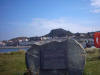
Harbour. I live near Dungeness at Littlestone. You will be aware that bits of
the Harbour broke away and one piece landed off our beach. It's still clearly
visible to this day. It is now a memorial where wreaths are placed from time
to time. I enclose a photograph. Several houses by the beach have Mulberry in
their names. Norma Oakeley. Mulberry
at Dungeness. We visited Gairleston in Scotland last year and were
interested to find that experimenting had been done there for the Mulberry
Harbour. I live near Dungeness at Littlestone. You will be aware that bits of
the Harbour broke away and one piece landed off our beach. It's still clearly
visible to this day. It is now a memorial where wreaths are placed from time
to time. I enclose a photograph. Several houses by the beach have Mulberry in
their names. Norma Oakeley.


Mulberry
at Aldwick. These dramatic and atmospheric shots are of a long abandoned
"Beetle" on the beach at Aldwick near Bognor Regis, on the south coast of
England. Beetles were concrete and steel
floats or pontoons that supported the roadways. Each was capable of carrying 56
tons + 25 tons - the weight of a tank.
Photos provided by Richard Carford.
|


