(Translated by https://www.hiragana.jp/)
National Hurricane Center
Skip Navigation Links
NOAA NOAA United States Department of Commerce

  Top News of the Day... view past news Last update Mon, 7 Oct 2024 06:39:45 UTC  
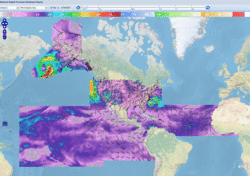
blue line for news table
tab Central Pacific tab Eastern Pacific tab tab Atlantic tab
tab

Click for Eastern Pacific
Active Storms  |  Marine Forecasts
2-Day Graphical Tropical Weather Outlook  |  7-Day Graphical Tropical Weather Outlook
Tropical Atlantic Full Basin Gulf of Mexico Atlantic Offshore Waters Caribbean Tropical East Pacific Forecast Graphics Tropical East Pacific Full Basin Mexico Offshore Waters Central America Offshore Waters North Atlantic Marine Forecasts

Atlantic - Caribbean Sea - Gulf of Mexico
Tropical Weather Outlook (en Español)
200 AM EDT Mon Oct 7 2024
Tropical Weather Discussion
0605 UTC Mon Oct 7 2024
TC Type Image Hurricane Milton RSS Feed icon Satellite | Buoys | Grids | Storm Archive
...MILTON MOVING ERRATICALLY EASTWARD THROUGH THE SOUTHERN GULF OF MEXICO... ...LIKELY TO BECOME A MAJOR HURRICANE ON LATER TODAY...
1:00 AM CDT Mon Oct 7
Location: 22.2°N 93.0°W
Moving: E at 6 mph
Min pressure: 975 mb
Max sustained: 90 mph

Public
Advisory
#7A

100 AM CDT
Forecast
Advisory
#7

0300 UTC
Forecast
Discussion
#7

1000 PM CDT
Wind Speed
Probabilities
#7

0300 UTC
Productos en español:
(más información)
Aviso
Publico

Pronóstico
Discusión

34-knot Wind Speed Probability
Wind Speed
Probabilities
Earliest Reasonable Time of Arrival of 34-knot winds
Arrival Time
of Winds
Wind History
Wind
History
Google Maps API Warnings and Track Forecast Cone
Warnings/Cone
Interactive Map
Warnings and 5-Day Cone
Warnings/Cone
Static Images
Surface Wind Field
Warnings and
Surface Wind
Key Messages
Key
Messages

Mensajes Claves
Mensajes
Claves

Potential Storm Surge Inundation
Storm Surge
Inundation

WPC Rainfall Potential thumbnail
Rainfall
Potential

WPC Flash Flooding Potential thumbnail
Flash Flooding
Potential
TC Type Image Hurricane Leslie RSS Feed icon Satellite | Buoys | Grids | Storm Archive
...LESLIE MAINTAINING ITS STRENGTH AS IT CONTINUES NORTHWESTWARD...
11:00 PM AST Sun Oct 6
Location: 15.0°N 39.4°W
Moving: NW at 12 mph
Min pressure: 980 mb
Max sustained: 90 mph

Public
Advisory
#19

1100 PM AST
Forecast
Advisory
#19

0300 UTC
Forecast
Discussion
#19

1100 PM AST
Wind Speed
Probabilities
#19

0300 UTC
Productos en español:
(más información)
Aviso
Publico

Pronóstico
Discusión

34-knot Wind Speed Probability
Wind Speed
Probabilities
Earliest Reasonable Time of Arrival of 34-knot winds
Arrival Time
of Winds
Wind History
Wind
History
Google Maps API Warnings and Track Forecast Cone
Warnings/Cone
Interactive Map
Warnings and 5-Day Cone
Warnings/Cone
Static Images
Surface Wind Field
Warnings and
Surface Wind
TC Type Image Hurricane Kirk RSS Feed icon Satellite | Buoys | Grids | Storm Archive
...KIRK EXPECTED TO BECOME EXTRATROPICAL ON MONDAY... ...STILL CAUSING LARGE SWELLS AND RIP CURRENT RISK ALONG U.S. EAST COAST...
3:00 AM GMT Mon Oct 7
Location: 38.6°N 43.6°W
Moving: NE at 25 mph
Min pressure: 964 mb
Max sustained: 80 mph

Public
Advisory
#31

300 AM GMT
Forecast
Advisory
#31

0300 UTC
Forecast
Discussion
#31

300 AM GMT
Wind Speed
Probabilities
#31

0300 UTC
Productos en español:
(más información)
Aviso
Publico

Pronóstico
Discusión

34-knot Wind Speed Probability
Wind Speed
Probabilities
Earliest Reasonable Time of Arrival of 34-knot winds
Arrival Time
of Winds
Wind History
Wind
History
Google Maps API Warnings and Track Forecast Cone
Warnings/Cone
Interactive Map
Warnings and 5-Day Cone
Warnings/Cone
Static Images
Surface Wind Field
Warnings and
Surface Wind


Eastern North Pacific (East of 140°W)
Tropical Weather Outlook (en Español)
1100 PM PDT Sun Oct 6 2024
Tropical Weather Discussion
0405 UTC Mon Oct 7 2024
There are no tropical cyclones in the Eastern North Pacific at this time.


Central North Pacific (140°W to 180°)
Tropical Weather Outlook
800 PM HST Sun Oct 6 2024
There are no tropical cyclones in the Central North Pacific at this time.