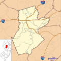
File:Location map of Somerset County, New Jersey.svg
From Wikimedia Commons, the free media repository
Jump to navigation
Jump to search

Size of this PNG preview of this SVG file: 600 × 600 pixels. Other resolutions: 240 × 240 pixels | 480 × 480 pixels | 768 × 768 pixels | 1,024 × 1,024 pixels | 2,048 × 2,048 pixels.
Original file (SVG file, nominally 768 × 768 pixels, file size: 354 KB)
File information
Structured data
Captions
Captions
Add a one-line explanation of what this file represents
Summary
[edit]| DescriptionLocation map of Somerset County, New Jersey.svg |
English: This is a map of Somerset County, New Jersey, USA. |
| Date | |
| Source | My own work, using custom-written MapScript applications with United States Census Bureau data |
| Author | Omnedon |
Licensing
[edit]| Public domainPublic domainfalsefalse |
| I, the copyright holder of this work, release this work into the public domain. This applies worldwide. In some countries this may not be legally possible; if so: I grant anyone the right to use this work for any purpose, without any conditions, unless such conditions are required by law. |
File history
Click on a date/time to view the file as it appeared at that time.
| Date/Time | Thumbnail | Dimensions | User | Comment | |
|---|---|---|---|---|---|
| current | 22:55, 10 January 2023 |  | 768 × 768 (354 KB) | X5163x (talk | contribs) | Merged Princeton Township and Borough (was merged since 2013) |
| 15:37, 20 September 2012 |  | 768 × 768 (355 KB) | Omnedon (talk | contribs) | ||
| 15:34, 20 September 2012 |  | 768 × 768 (350 KB) | Omnedon (talk | contribs) | ||
| 14:20, 16 September 2012 |  | 768 × 768 (305 KB) | Omnedon (talk | contribs) | ||
| 00:06, 29 August 2012 |  | 768 × 768 (272 KB) | Omnedon (talk | contribs) | == {{int:filedesc}} == {{Information |Description={{en|This is a map of Somerset County, New Jersey, USA.}} |Source=My own work, using custom-written [http://mapserver.org/mapscript/ MapScript] applications with [http... |
You cannot overwrite this file.
File usage on Commons
There are no pages that use this file.
File usage on other wikis
The following other wikis use this file:
- Usage on ar.wikipedia.org
- Usage on azb.wikipedia.org
- مدیلبوش، نیوجرسی
- پلیزنت پلینز، نیوجرسی
- لمینقتون، نیوجرسی
- فلاقتاون، نیوجرسی
- بلکولز میلز، نیوجرسی
- فرانکلین پارک، نیوجرسی
- تن مایل ران، نیوجرسی
- بسکینق ریج، نیوجرسی
- مارتینزویل، نیوجرسی
- فرنکلین سنتر، نیوجرسی
- قلادستون، نیوجرسی
- اسکیلمن، نیوجرسی
- واتسون، نیوجرسی
- ایست فرانکلین، نیوجرسی
- قرین نول، نیوجرسی
- بردلی قاردنز، نیوجرسی
- فایندرن، نیوجرسی
- ایست راکی هیل، نیوجرسی
- بل مد، نیوجرسی
- وورهیز ، نیوجرسی
- هارلینقتون، نیوجرسی
- بلائنبرق، نیوجرسی
- زارفت، نیوجرسی
- کلاید، نیوجرسی
- پلوکمین، نیوجرسی
- زیون، نیوجرسی
- لیونز، نیوجرسی
- میدلبروک، نیوجرسی
- Usage on ceb.wikipedia.org
- Usage on en.wikipedia.org
- Bedminster, New Jersey
- Bernards Township, New Jersey
- Bernardsville, New Jersey
- Bound Brook, New Jersey
- Branchburg, New Jersey
- Bridgewater Township, New Jersey
- Far Hills, New Jersey
- Franklin Township, Somerset County, New Jersey
- Green Brook Township, New Jersey
- Hillsborough Township, New Jersey
- Manville, New Jersey
- Millstone, New Jersey
- Montgomery Township, New Jersey
- North Plainfield, New Jersey
- Peapack-Gladstone, New Jersey
- Raritan, New Jersey
- Rocky Hill, New Jersey
- Somerset, New Jersey
- Somerville, New Jersey
- South Bound Brook, New Jersey
View more global usage of this file.
Metadata
This file contains additional information such as Exif metadata which may have been added by the digital camera, scanner, or software program used to create or digitize it. If the file has been modified from its original state, some details such as the timestamp may not fully reflect those of the original file. The timestamp is only as accurate as the clock in the camera, and it may be completely wrong.
| Width | 768 |
|---|---|
| Height | 768 |