File:Union State (Crimea and eastern Ukraine disputed).svg
From Wikimedia Commons, the free media repository
Jump to navigation
Jump to search

Size of this PNG preview of this SVG file: 541 × 541 pixels. Other resolutions: 240 × 240 pixels | 480 × 480 pixels | 768 × 768 pixels | 1,024 × 1,024 pixels | 2,048 × 2,048 pixels.
Original file (SVG file, nominally 541 × 541 pixels, file size: 442 KB)
File information
Structured data
Captions
Captions
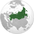
The current (disputed) borders of the Union State of Russia and Belarus following the September 2022 annexations of Luhansk, Donetsk, Zaporizhzhia, and Kherson.
Die aktuelle (strittige) Grenze der Russisch-Belarussischen Union nach September 2022.
Summary
[edit]| DescriptionUnion State (Crimea and eastern Ukraine disputed).svg |
English: The current (disputed) borders of the Union State of Russia and Belarus following the September 2022 annexations of Luhansk, Donetsk, Zaporizhzhia, and Kherson. |
| Date | |
| Source | Own work |
| Author | Jazzertyy |
Licensing
[edit]| Public domainPublic domainfalsefalse |
| This map is ineligible for copyright and therefore in the public domain, because it consists entirely of information that is common property and contains no original authorship. For more information, see Commons:Threshold of originality § Maps.
English | Español | Galego | Română | slovenščina | العربية | 简体 |
File history
Click on a date/time to view the file as it appeared at that time.
| Date/Time | Thumbnail | Dimensions | User | Comment | |
|---|---|---|---|---|---|
| current | 13:25, 24 February 2023 |  | 541 × 541 (442 KB) | Stjn (talk | contribs) | Reverted to version as of 21:56, 3 October 2022 (UTC): although Kuril Islands are also disputed, they don't have the same level of significance as occupied territories of Ukraine, so it's better to keep a separate map with them for that use case |
| 02:59, 13 February 2023 |  | 536 × 537 (440 KB) | Jamie Eilat (talk | contribs) | Changed color of disputed Kuril Islands dispute to match the disputed annexation of east Ukraine. | |
| 21:56, 3 October 2022 |  | 541 × 541 (442 KB) | Jazzertyy (talk | contribs) | Uploaded own work with UploadWizard |
You cannot overwrite this file.
File usage on Commons
The following 6 pages use this file:
File usage on other wikis
The following other wikis use this file:
- Usage on ast.wikipedia.org
- Usage on bg.wikipedia.org
- Usage on ca.wikipedia.org
- Usage on fi.wikipedia.org
- Usage on fr.wikipedia.org
- Usage on he.wikipedia.org
- Usage on ru.wikipedia.org
- Usage on ru.wikinews.org
- Usage on sv.wikipedia.org
- Usage on vi.wikipedia.org
- Usage on www.wikidata.org
Metadata
This file contains additional information such as Exif metadata which may have been added by the digital camera, scanner, or software program used to create or digitize it. If the file has been modified from its original state, some details such as the timestamp may not fully reflect those of the original file. The timestamp is only as accurate as the clock in the camera, and it may be completely wrong.
| Width | 541.47876 |
|---|---|
| Height | 541.47876 |