Datei:Global carbon dioxide AIRS.jpg
Zur Navigation springen
Zur Suche springen
Es ist keine höhere Auflösung vorhanden.
Global_carbon_dioxide_AIRS.jpg (496 × 392 Pixel, Dateigröße: 28 KB, MIME-Typ: image/jpeg)
![]()
Diese Datei und die Informationen unter dem roten Trennstrich werden aus dem zentralen Medienarchiv Wikimedia Commons eingebunden.
![]()
Beschreibung
| Beschreibung |
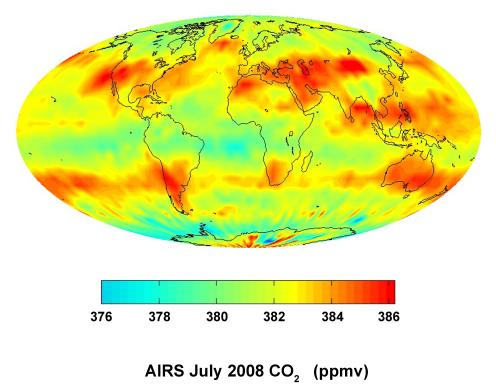
English: This global satellite map shows carbon dioxide in the mid-troposphere, about 8 kilometers above Earth. It was created with data acquired by the Atmospheric Infrared Sounder (AIRS) instrument during July 2008.
The distribution of carbon dioxide in this region of the atmosphere is strongly influenced by major surface sources of carbon dioxide and by large-scale atmospheric circulation patterns, such as the jet streams and weather systems in Earth's mid-latitudes. Patterns of carbon dioxide distribution differ significantly between the northern hemisphere, with its many land masses, and the southern hemisphere, which is largely covered by ocean. AIRS is one of six instruments flying on NASA's Aqua satellite. English: Carte satellitale mondiale montrant le taux moyen de dioxyde de carbone dans la mi-troposphère (+/-8 kilomètres au-dessus du niveau de la mer). Sa distribution à cette altitude est encore très influencée par les sources de surface mais elle subit aussi les grands courants de circulation atmosphérique (jets et systèmes météorologiques actifs aux latitudes moyennes de la Terre). Les schémas de distribution du CO2 diffèrent considérablement entre l'hémisphère nord, avec ses nombreuses masses terrestres très anthropisées, et l'hémisphère sud, plus largement recouvert par l'océan. Données acquises par l'instrument Atmospheric Infrared Sounder (AIRS) en juillet 2008 ; AIRS est l'un des six instruments embarqués sur le satellite Aqua de la NASA |
| Datum | |
| Quelle | http://photojournal.jpl.nasa.gov/catalog/PIA11194 |
| Urheber | NASA/JPL |
Diese Mediendatei wurde vom Jet Propulsion Lab der US-amerikanischen National Aeronautics and Space Administration (NASA) unter der Datei-ID PIA11194 kategorisiert. Diese Markierung zeigt nicht den Urheberrechtsstatus des zugehörigen Werks an. Es ist in jedem Falle zusätzlich eine normale Lizenzvorlage erforderlich. Siehe Commons:Lizenzen für weitere Informationen. Sprachen:
|


Lizenz
| Diese Datei ist gemeinfrei (public domain), da sie von der NASA erstellt worden ist. Die NASA-Urheberrechtsrichtlinie besagt, dass „NASA-Material nicht durch Urheberrecht geschützt ist, wenn es nicht anders angegeben ist“. (NASA-Urheberrechtsrichtlinie-Seite oder JPL Image Use Policy). | ||
 |
Warnung:
|
Dateiversionen
Klicke auf einen Zeitpunkt, um diese Version zu laden.
| Version vom | Vorschaubild | Maße | Benutzer | Kommentar | |
|---|---|---|---|---|---|
| aktuell | 23:23, 9. Mär. 2012 | | 496 × 392 (28 KB) | Ras67 | losslessly cropped with Jpegcrop |
| 19:16, 25. Okt. 2008 |  | 666 × 500 (31 KB) | Maddox1 | {{Information |Description={{en|1=This global satellite map shows carbon dioxide in the mid-troposphere, about 8 kilometers above Earth. It was created with data acquired by the Atmospheric Infrared Sounder (AIRS) instrument during July 2008. The di |
Dateiverwendung
Die folgenden 2 Seiten verwenden diese Datei:
Globale Dateiverwendung
Die nachfolgenden anderen Wikis verwenden diese Datei:
- Verwendung auf ar.wikipedia.org
- Verwendung auf de.wikiversity.org
- Verwendung auf en.wikipedia.org
- Verwendung auf en.wikibooks.org
- Verwendung auf fr.wikipedia.org
- Verwendung auf fr.wikiversity.org
- Verwendung auf no.wikipedia.org
- Verwendung auf vi.wikipedia.org