This article includes a list of general references, but it lacks sufficient corresponding inline citations. (February 2010) |
The Japanese addressing system is used to identify a specific location in Japan.
When written in Japanese characters, addresses start with the largest geographical entity and proceed to the most specific one. The Japanese system is complex and idiosyncratic, the product of the natural growth of urban areas, as opposed to the systems used in cities that are laid out as grids and divided into quadrants or districts.
When written in Latin characters, addresses follow the convention used by most Western addresses and start with the smallest geographic entity (typically a house number) and proceed to the largest. However, even when translated using Latin characters, Japan Post requires that the address also be written in Japanese to ensure correct delivery.[1]
Address parts
edit
Japanese addresses begin with the largest division of the country, the prefecture. Most of these are called ken (
Following the prefecture is the municipality. For a large municipality this is the city (shi,
For addressing purposes, municipalities may be divided into chō or machi (two different readings of the character
- Municipality is divided first into machi and then into city districts (
丁 目 chōme). Example:台東 区 [浅草 四 丁目 ] (Taito-ku, [Asakusa, 4-chōme]) - Municipality is divided into ō-aza (
大字 ), which may be divided into aza (字 ), which may in turn be divided into ko-aza (小字 ). Example:青森 市 [大字 滝沢 字 住吉 ] (Aomori-shi, [ō-aza Takizawa, aza Sumiyoshi])
However, exceptions abound, and the line between the schemes is often blurry as there are no clear delimiters for machi, aza, etc. There are also some municipalities like Ryūgasaki, Ibaraki which do not use any subdivisions.
Below this level, two styles of addressing are possible.
- In the newer jūkyo hyōji (
住居 表示 ) style, enacted into law by the 1962 Act on Indication of Residential Address (住居 表示 に関 する法律 )[4] and used by the majority of the country, the next level is the city block (街 区 gaiku), always followed by the building number (番号 bangō). Building 10 in block 5 would be formally written as 5番 10号 (5-ban 10-gō). For apartment buildings, the apartment number (部屋 番号 heya bangō) may be appended to the building with a hyphen, so apartment 103 in the aforementioned building would be 5番 10-103号 . - In the older chiban (
地番 ) style, still used in some rural and older city areas, the next level is the area/block name (地区 chiku, often abbreviated as区 ku), the next smaller level is the lot number (番地 banchi), optionally followed by a lot number extension (formally shigō (支 号 ), more often edaban (枝 番 )). The lot number designates a plot of land registered in the land registry, and a lot number extension is assigned when a piece of land is divided into two or more pieces in the registry. This can be written as any of 3番地 5 (3-banchi 5), 3番地 の5 (3-banchi-no 5) or 3番 5 (3-ban 5). Land not designated by the registry is known as mubanchi (無 番地 ), with any dwellings there being bangaichi (番外地 ).
In both styles, since all address elements from chōme down are numeric, in casual use it is common to form them into a string separated by hyphens or the possessive suffix の (no), resulting in Asakusa 4-5-10 or Asakusa 4の5の10. This renders the two styles indistinguishable, but since each municipality adopts one style or the other, there is no risk of ambiguity. The apartment number may also be appended, resulting in 4-5-10-103.

Street names are seldom used in postal addresses (except in Kyoto and some Hokkaidō cities such as Sapporo).
Banchi blocks often have an irregular shape, as banchi numbers were assigned by order of registration in the older system, meaning that especially in older areas of the city they will not run in a linear order. For this reason, when giving directions to a location, people will often offer cross streets, visual landmarks and subway stations, such as "at Chūō-dori and Matsuya-dori across the street from Matsuya and Ginza station" for a store in Tokyo. Many businesses feature maps on their literature and business cards. Signs attached to utility poles often specify the city district name and block number, and detailed block maps of the immediate area are sometimes posted near bus stops and train stations in larger cities.
In addition to the address itself, all locations in Japan have a postal code. After the reform of 1998, this begins with a three-digit number, a hyphen, and a four-digit number, for example 123-4567. A postal mark, 〒, may precede the code to indicate that the number following is a postal code.
Address order
editIn Japanese, the address is written in order from largest unit to smallest, with the addressee's name last of all. For example, the address of the Tokyo Central Post Office is
- 〒100-8994
東京 都 千代田 区 丸ノ内 二 丁目 7番 2号
東京 中央 郵便 局
- 〒100-8994
Tōkyō-to Chiyoda-ku Marunouchi 2-Chōme 7-ban 2-gō
Tōkyō Chūō Yūbin-kyoku
or
- 〒100-8994
東京 都 千代田 区 丸ノ内 2-7-2
東京 中央 郵便 局
- 〒100-8994
Tōkyō-to Chiyoda-ku Marunouchi 2-7-2
Tōkyō Chūō Yūbin-kyoku
The order is reversed when writing in rōmaji. The format recommended by Japan Post[5] is:
- Tokyo Central Post Office
7-2, Marunouchi 2-Chome
Chiyoda-ku, Tokyo 100-8994
In this address, Tokyo is the prefecture; Chiyoda-ku is one of the special wards; Marunouchi 2-Chome is the name of the city district; and 7-2 is the city block and building number. In practice[6] it is common for the chōme to be prefixed, as in Japanese, resulting in the somewhat shorter:
- Tokyo Central Post Office
2-7-2 Marunouchi, Chiyoda-ku
Tokyo 100-8994
While almost all elements of the address are reversed when written in rōmaji, connected strings of numbers are treated as units and not reversed. Firstly, the "city block and building number" is a unit, and its digits are not reversed – in this example it is "7-2" in both Japanese and roman, though the Japanese (literally Marunouchi 2-Chōme 7-2) is partly reversed to "7-2, Marunouchi 2-Chōme" in roman if chōme is separate. Similarly, if the chōme is included, these also form a unit, so in this example the string is 2-7-2 in both Japanese and Western alphabet.
Special cases
editAs mentioned above, there are certain areas of Japan that use somewhat unusual address systems. Sometimes the differing system has been incorporated into the official system, as in Sapporo, while in Kyoto the system is completely different from, but used alongside the official system. Kyoto and Sapporo have addresses based on their streets being laid out in a grid plan, unlike most Japanese cities.
Kyoto
edit
Although the official national addressing system is in use in Kyoto – in Chiban style, with ward (
For added precision, the street-based address can be given, followed by the chō and land number. Sometimes multiple houses share a given land number, in which case the name (either just family name, or full name of resident) must also be specified; this name is generally displayed in front of the house on a hyōsatsu (
The system works by naming the intersection of two streets and then indicating if the address is north (
For instance, the address of Kyoto Tower is listed on their website as:[7]
- 〒600-8216
京都 市 下京 区 烏丸 通 七 条 下 ル東塩小路 町 721-1
Following the postcode, this contains the city and ward, followed by the unofficial address, a space, and then the official address:
京都 市 下京 区 Kyōto-shi, Shimogyō-ku烏丸 七 条 下 ル Karasuma-Shichijō-sagaru東塩小路 町 721-1 Higashi-Shiokōji 721-1
This address means "south of the intersection of Karasuma and Shichijō streets" – more precisely, "on Karasuma, below (south of) Shichijō" (Karasuma runs north–south, while Shichijō is an east–west cross street). The street address may alternatively be given as
However, the system is flexible and allows for various alternatives, such as:
京都 府 京都 市 下京 区 烏丸 塩小路 上 ル- Kyōto-fu, Kyōto-shi, Shimogyō-ku, Karasuma-Shiokōji-agaru
- "(On) Karasuma (street), above (north of) Shiokōji (street)"
For less well known buildings, the official address is often given after the informal one, as in the address for the Shinatora Ramen restaurant:
京都 府 京都 市 下京 区 烏丸 通 五条 下 ル大坂 町 384- Kyōto-fu, Kyōto-shi, Shimogyō-ku, Karasuma-dōri-Gojō-sagaru, Ōsakachō 384
- "Ōsakachō 384, (on) Karasuma street, below (south of) Gojō"
As the initial part of the address is familiar, it is often abbreviated – for example, Kyōto-fu, Kyōto-shi (
- 〒600-8216
京 、下 、烏丸 七 条 下 - Karasuma-Shichijō-sagaru, Shimo–, Kyō–, 600-8216
Sapporo
editSapporo's system, though official, differs in structure from regular Japanese addresses. The city-center is divided into quadrants by two intersecting roads, Kita-Ichijo and Soseigawa; blocks are then named based on their distance from this point, and farther from the city center, multiple blocks are included in each. The east–west distance is indicated by chōme (a slightly unorthodox usage of chōme), while the north–south distance is indicated by jō, which has been incorporated into the chō name.
The address to Sapporo JR Tower is:[8]
札幌 市 中央 区 北 5条 西 2丁目 5番地 - Sapporo-shi, Chūō-ku, kita-5-jō-nishi 2-chōme 5-banchi
This address indicates that it is the fifth building on a block located on 5 jō north and 2 chōme west of the center, named with the actual cardinal names of kita (north), minami (south), nishi (west), and higashi (east). The directional names for jō extend for about 7 kilometers to the north–south along the main Soseigawa Dori, but only about 3 kilometers at the most to the east and west; outside of that area, jō have other names, though the starting point of each is still the corner in the direction of the city center, often using landmarks such as the Hakodate Main Line or large roads to mark the new numbering.
For example, far in the outskirts is the Sapporo Tachibana Hospital, at:[9]
- 〒006-0841
札幌 市 手稲 区 曙 11条 2丁目 3番 12号 - Sapporo-shi, Teine-ku, Akebono-11-jō, 2-chōme-3-ban-12-gō
Building 12 on block 3 of a chōme measuring 11 jō north and 2 chōme west of where the Hakodate Main Line meets Tarukawa Street. Or Toyohira Ward office, at:[10]
- 〒062-0934
札幌 市 豊平 区 平岸 6条 10丁目 1-1 - Sapporo, Toyohira-ku, Hiragishi-6-jō, 10-chōme-1-ban-1-gō
Building 1 on block 1 of a chōme measuring 6 jō south and 10 chōme east of where a small street meets the Toyohira River. The direction is understood based on the quadrant of the city the jō is considered to be in, which may be off from the actual direction to the city center, depending on the landmark used.
Far-flung and less crowded parts of the city may instead use a standard chō name, rather than a numbered jō, such as Makomanai.
Ōita
editMany areas of Ōita Prefecture including the cities of Ōita and Usuki commonly use an unofficial parallel system known as "administrative wards" (
大分 県 大分 市 羽屋 4-1-A組 - Haneya 4-1-A-kumi, Ōita-shi, Ōita-ken
大分 県 臼杵 市 臼杵 洲崎 四 丁目 1組 - Suzaki 4-chōme 1-kumi, Usuki-shi, Ōita-ken
As the names indicate, these derive from traditional neighbourhood councils. While they continue to be used locally (e.g. school and electoral districts) and may be accepted for mail delivery, they are not considered official addresses, and individual buildings in each kumi will also have a standard ōaza-banchi address.[11] For example, Usuki City Hall, while within Suzaki 4-chome 1-kumi, has the formal address of Usuki 72–1, which may be prepended with ōaza for clarity:
- 〒875-8501
大分 県 臼杵 市 大字 臼杵 72-1- Ōaza Usuki 72-1, Usuki-shi, Ōita-ken 875-8501
Katakana blocks (bu)
editSome cities in Ishikawa Prefecture, including Kanazawa and Nanao, sometimes use katakana in the iroha ordering (イ・ロ・ハ・ニ ... ) instead of numbers for blocks. These are called bu (
- 〒926-0192
石川 県 七尾 市 和倉 町 ヨ80 - Wakuramachi yo 80, Nanao-shi, Ishikawa-ken 926-0192
Jikkan instead of numbered chōme
editSome cities, including parts of Nagaoka, Niigata, use jikkan (
- 〒940-2402
新潟 県 長岡 市 与板 町 与板 乙 5881-3 - Yoita-otsu 5881-3, Yoita-machi, Nagaoka-shi, Niigata-ken 940-2402
History
editThe current addressing system was established after World War II as a slight modification of the scheme used since the Meiji era.
For historical reasons, names quite frequently conflict. It is typical in Hokkaidō where many place names are identical to those found in the rest of Japan, for example Shin-Hiroshima (literally new Hiroshima) to Hiroshima,[14] largely as the result of the systematic group emigration projects since the late 19th century to Hokkaidō; people from villages across mainland Japan dreamt to become wealthy farmers. Historians note that there is also a significant similarity between place names in Kansai region and those in northern Kyūshū. See Japanese place names for more.
Named roads
editNamed roads (
Gallery
edit-
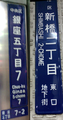 Two "chōmei-name plates (
町名 板 )" are with rōmaji for people unable to read the Japanese. (L) - A plate in standard style in larger cities. The letters on the plate indicates from the top Chuō Ward (中央 区 , Chuō-ku) and block 7, 5th chōme (銀座 五 丁目 7, Ginza go-chōme nana). At the very bottom, 7-2 stands for block 7, number (banchi) 2. Pictured on the Ginza 4-chōme koban police box at the Ginza 4-chōme crossing, on Ginza main street facing to Wakō. (R) - Pictured is the one without any banchi numbers at the 2nd block in Shimbashi (新橋 二 丁目 , Shimbashi ni-chōme). In Japanese writing at the bottom it reads you are in the underground city at the east gate (東口 地下街 , Higashi-guchi chikagai), but the name for Shimbashi station is not indicated. -
 In the residential area, this type of green street address or chōmei name plates are applied. Pictured is an old type without roman scripts or city name, at Kuwabara in Matsuyama, Ehime. The address of the city block in Japanese means block 3, 4-chōme, Kuwabara town (
桑原 四 丁目 3, Kuwabara yon-chōme san).


See also
editReferences
edit- ^ "
郵便 トラブルのQ&A -日本 郵便 ". www.post.japanpost.jp. Retrieved 2023-10-18. - ^
公益 財団 法人 特別 区 協議 会 Tokubetsu-ku Kyogikai (16 April 2019). "特別 区 とは" [About Special wards]. www.tokyo-23city.or.jp (in Japanese). Retrieved 2020-11-02. - ^ "トップページ" [Top page]. www.tokyo23city-kuchokai.jp (in Japanese).
特別 区長 会 (Mayors of Special Wards). Retrieved 2020-11-02. - ^ "
住居 表示 に関 する法律 : (昭和 三 十 七 年 五 月 十 日 法律 第 百 十 九 号 ,最終 改正 :平成 一 一 年 一 二 月 二 二 日 法律 第 一 六 〇号 )" [Jūkyo hyōji ni kansuru hōritsu (issued as Hōritsu No.119 as of 10 May 1962 with the latest revision: Hōritsu No.160 effective as of 22 December 1991)]. Law.e-gov.go.jp (in Japanese). 22 December 1999. Archived from the original on 30 January 2013. Retrieved 26 May 2017. - ^ "How to Fill Out EMS label - Japan Post". Post.japanpost.jp. Retrieved 26 May 2017.
- ^ "Corporate Information > About Japan Post". Archived from the original on 2010-04-12. Retrieved 2010-04-24.
- ^ "アクセス" [Access]. Kyoto-tower.co.jp (in Japanese). Archived from the original on 2016-08-09. Retrieved 2016-05-25.
- ^ "
会社 概要 | JRタワー札幌 駅 から直結 のショッピングセンター 〈アピア・エスタ・パセオ・札幌 ステラプレイス〉" [About us | JR Tower, shopping malls connected to Sapporo station (Apia, Esta, Paseo, and Sapporo Stella Place)]. Jr-tower.com (in Japanese). Retrieved 2017-05-27. - ^ "
札幌 立花 病院 | -アクセス" [Sapporo Tachibana Hospital | Access]. Fukuwakai.or.jp (in Japanese). Retrieved 2017-05-27. - ^ "
区役所 案内 " [Ward office guide]. City.sapporo.jp (in Japanese).札幌 市 豊平 区役所 [Toyohira Ward, City of Sapporo]. Retrieved 2017-05-27. - ^ a b "
暮 らしの窓口 >住民 基本 台帳 >住民 異動 届 " [Life events > Basic Resident Register > Reporting address change]. Wayback Machine.臼杵 市役所 [City of Usuki]. Archived from the original on 2013-07-20. - ^ "
会社 概要 |企業 サイト" [Company profile]. Kagaya.co.jp (in Japanese).和倉温泉 加賀屋 グループ Kagaya Group, Wakura onsen hot-spring. Retrieved 2017-05-27. - ^ "
新潟 県 警察 ホームページ -警察 本部 ・警察 署 のご案内 【県内 の警察 署 :与板 警察 署 】" [Home > Guide to the headquarters and police stations > local police stations in our prefecture > Yoita police station]. Police.pref.niigata.jp (in Japanese).新潟 県 警察 Nigata Prefecture Police. Archived from the original on December 19, 2012. Retrieved 2017-05-27. - ^
北海道 の地名 (Hokkaido no chimei) Place Names in Hokkaido (in Japanese). Heibonsha. October 2003. ISBN 9784582490015.
External links
edit- The Japanese address system
- Postal Information for Japan, Japan-guide.com
- Japanese 2005 census - definition of shi,ku, &c.
- Japan addressing Archived 2020-02-20 at the Wayback Machine, Universal Postal Union