Spratly Island: Difference between revisions
Ein Dahmer (talk | contribs) mNo edit summary |
No edit summary |
||
| Line 9: | Line 9: | ||
| url = http://www.southchinasea.org/macand/gazetteer.htm |
| url = http://www.southchinasea.org/macand/gazetteer.htm |
||
| accessdate = 2008-03-22 }}</ref> This island, controlled by Vietnam since 1974, is also claimed by [[People's Republic of China|China]], [[Republic of China|Taiwan]] and the [[Philippines]]. |
| accessdate = 2008-03-22 }}</ref> This island, controlled by Vietnam since 1974, is also claimed by [[People's Republic of China|China]], [[Republic of China|Taiwan]] and the [[Philippines]]. |
||
In the summer of 1996, the first Philippines-Vietnam Joint Oceanographic and Marine Scientific Research Expedition (JOMSRE-SCS) was conducted in the South China Sea aboard the [http://www.mgb.gov.ph/pgs.aspx?pgsid=18 RPS Explorer] of the [[Mines and Geosciences Bureau]]. The Philippine contingent was headed by Dr. Gil Jacinto of the Marine Science Institute of the University of the Philippines with the following complement: Allan Antonio C. Conda, Lian Talaue McManus, Johnathan Molina,Porfiro Alexander M. Alilio, Marites Ramirez Alsisto, Cesar S. de Chavez, Federico A. Balanon, Maria Catalina Gloria Ranola, Reuben Campos, Cristine Ingrid S. Narcise, Cesar L. Villanoy, Cleto L. Nanola and Ramon V. Macabuhay, Jr. |
|||
==See also== |
==See also== |
||
Revision as of 02:48, 15 December 2010
Spratly Island or Truong Sa Island (Tagalog: Lagos; Chinese:
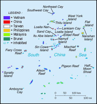
Named as Truong Sa, the island is controlled and administered by the government of Vietnam. The island has a variety of vegetation and is upgraded to township. The island has more than 1000 citizens and soldiers[citation needed]. It is the administrative island for all nearby islands, has a 610 metres (667 yd) landing strip and a small jetty.
With an area of 13 hectares, it is the fourth largest Spratly island and the largest among Vietnamese-occupied Spratly islands. Covered with bushes and grass, the island is home to some birds and has guano deposits. A 5.5 m-high obelisk is present at the southern tip. The fringing reef is above water at low tide.[1] This island, controlled by Vietnam since 1974, is also claimed by China, Taiwan and the Philippines.
In the summer of 1996, the first Philippines-Vietnam Joint Oceanographic and Marine Scientific Research Expedition (JOMSRE-SCS) was conducted in the South China Sea aboard the RPS Explorer of the Mines and Geosciences Bureau. The Philippine contingent was headed by Dr. Gil Jacinto of the Marine Science Institute of the University of the Philippines with the following complement: Allan Antonio C. Conda, Lian Talaue McManus, Johnathan Molina,Porfiro Alexander M. Alilio, Marites Ramirez Alsisto, Cesar S. de Chavez, Federico A. Balanon, Maria Catalina Gloria Ranola, Reuben Campos, Cristine Ingrid S. Narcise, Cesar L. Villanoy, Cleto L. Nanola and Ramon V. Macabuhay, Jr.
See also
References
- ^ "Digital Gazetter of Spratly Islands". Retrieved 2008-03-22.

