
File:Morrell Antarctic Voyage 1822.png
No higher resolution available.
Morrell_Antarctic_Voyage_1822.png (502 × 483 pixels, file size: 15 KB, MIME type: image/png)
| This is a file from the Wikimedia Commons. Information from its description page there is shown below. Commons is a freely licensed media file repository. You can help. |
Summary
| Description |
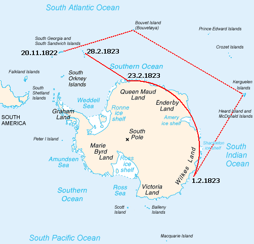
English: Map of the reported sea voyage of Benjamin Morrell near Antarctica in 1822-23. |
| Date | |
| Source | Own work based on: Antarctica Map.png + Morrell, Benjamin (1832) A Narrative of Four Voyages...etc, New York: J & J Harper, pp. 58–66 |
| Author | User:Ruhrfisch adapted this from the map by Lupo, itself from the CIA factbook maps. |
Licensing
This image is in the public domain because it contains materials that originally came from the United States Central Intelligence Agency's World Factbook.
|
 |
File history
Click on a date/time to view the file as it appeared at that time.
| Date/Time | Thumbnail | Dimensions | User | Comment | |
|---|---|---|---|---|---|
| current | 16:20, 19 November 2010 | | 502 × 483 (15 KB) | Ras67 | cropped and squeezed |
| 18:55, 28 February 2009 |  | 504 × 485 (30 KB) | Ruhrfisch | {{Information |Description= Map of the reported sea voyage of Benjamin Morrell near Antarctica in 1822-23 |Source= Cropped and partially relabeled version of File:Antarctica Map.png with voyage line added by User:Ruhrfisch |
File usage
The following pages on the English Wikipedia use this file (pages on other projects are not listed):
Global file usage
The following other wikis use this file:
- Usage on ast.wikipedia.org
- Usage on es.wikipedia.org
- Usage on fi.wikipedia.org
- Usage on it.wikipedia.org
- Usage on ja.wikipedia.org