
File:Nuremberg network map.png
Size of this preview: 800 × 541 pixels. Other resolutions: 320 × 216 pixels | 640 × 433 pixels | 1,024 × 693 pixels | 1,280 × 866 pixels | 2,560 × 1,732 pixels | 4,964 × 3,358 pixels.
Original file (4,964 × 3,358 pixels, file size: 1.78 MB, MIME type: image/png)
| This is a file from the Wikimedia Commons. Information from its description page there is shown below. Commons is a freely licensed media file repository. You can help. |
Summary
| Description |
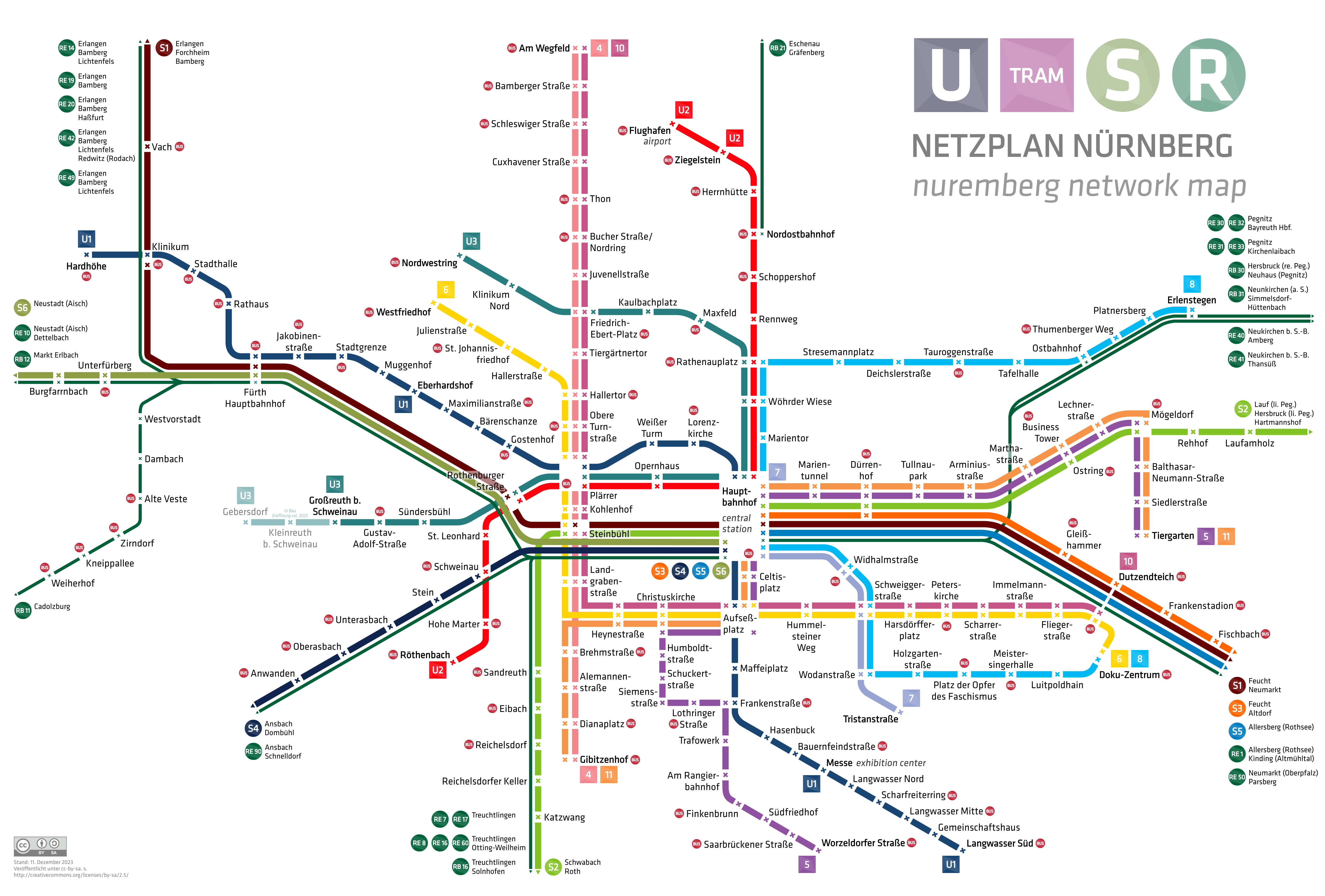
English: nuremberg city network map with underground, tramway, suburban railway and regional railway
|
| Date | |
| Source | Own work |
| Author | HerrMay |
Licensing
I, the copyright holder of this work, hereby publish it under the following license:
| This file is made available under the Creative Commons CC0 1.0 Universal Public Domain Dedication. | |
| The person who associated a work with this deed has dedicated the work to the public domain by waiving all of their rights to the work worldwide under copyright law, including all related and neighboring rights, to the extent allowed by law. You can copy, modify, distribute and perform the work, even for commercial purposes, all without asking permission.
|
File history
Click on a date/time to view the file as it appeared at that time.
| Date/Time | Thumbnail | Dimensions | User | Comment | |
|---|---|---|---|---|---|
| current | 20:13, 19 December 2023 | | 4,964 × 3,358 (1.78 MB) | HerrMay | Kleine Ausbesserungen |
| 05:43, 9 December 2023 |  | 4,964 × 3,358 (1.78 MB) | HerrMay | aktualisiert | |
| 23:19, 20 January 2022 |  | 4,964 × 3,358 (1.74 MB) | HerrMay | Fürther Stationen ausgebessert | |
| 06:06, 20 December 2021 |  | 4,964 × 3,358 (1.75 MB) | HerrMay | Namen ausgebessert | |
| 00:27, 7 December 2021 |  | 4,964 × 3,358 (1.75 MB) | HerrMay | S6 hinzugefügt | |
| 03:06, 15 October 2020 |  | 4,964 × 3,358 (1.63 MB) | HerrMay | U3 Verlängerung | |
| 16:27, 4 October 2020 |  | 4,964 × 3,358 (1.63 MB) | HerrMay | Stationsnamen korrigiert | |
| 16:17, 15 May 2020 |  | 4,964 × 3,358 (1.64 MB) | HerrMay | Ausbesserung Namen Thum(m)enberger Weg, Scheu(e)rlstraße | |
| 22:59, 20 April 2020 |  | 4,964 × 3,358 (1.64 MB) | HerrMay | aktualisiert Anwanden, Oberasbach | |
| 00:57, 25 February 2020 |  | 4,964 × 3,358 (1.62 MB) | HerrMay | aktualisiert Zirndorf, Oberasbach |
File usage
The following pages on the English Wikipedia use this file (pages on other projects are not listed):
Global file usage
The following other wikis use this file:
- Usage on ast.wikipedia.org
- Usage on cs.wikipedia.org
- Usage on de.wikipedia.org
- Usage on de.wikivoyage.org
- Usage on en.wikivoyage.org
- Usage on eo.wikipedia.org
- Usage on es.wikipedia.org
- Usage on eu.wikipedia.org
- Usage on fa.wikipedia.org
- Usage on fi.wikipedia.org
- Usage on fr.wikipedia.org
- Usage on hu.wikipedia.org
- Usage on id.wikipedia.org
- Usage on ja.wikipedia.org
- Usage on ka.wikipedia.org
- Usage on ko.wikipedia.org
- Usage on lt.wikipedia.org
- Usage on mhr.wikipedia.org
- Usage on no.wikipedia.org
- Usage on pl.wikivoyage.org
- Usage on simple.wikipedia.org
- Usage on sk.wikipedia.org
- Usage on uz.wikipedia.org
- Usage on www.wikidata.org