
Muroran
This article has multiple issues. Please help improve it or discuss these issues on the talk page. (Learn how and when to remove these template messages)
|
Muroran
| |
|---|---|
 Top:View of Muroran Refinery area at night, Cape of Chikyu and view of Pacific Ocean, (left to right) Middle:Muroran Aquarium, View of Muroran Station area and Mount Sokuryō, (left to right) Bottom:Night view of Hakuchō Bridge | |
 Flag  Chapter | |
 Location of Muroran in Hokkaido (Iburi Subprefecture) | |
 Muroran Location in Japan | |
| Coordinates: 42°19′N 140°58′E / 42.317°N 140.967°E | |
| Country | Japan |
| Region | Hokkaido |
| Prefecture | Hokkaido (Iburi Subprefecture) |
| Established | January 1593[citation needed] |
| City Status | August 1, 1922 |
| Government | |
| • Mayor | Takeshi Aoyama (since May 2011) |
| Area | |
| • Total | 80.88 km2 (31.23 sq mi) |
| Population (January 31, 2024) | |
| • Total | 76,385 |
| • Density | 940/km2 (2,400/sq mi) |
| Time zone | UTC+09:00 (JST) |
| City hall address | 1-2 Saiwaichō, Muroran-shi, Hokkaidō 051-8511 |
| Website | www |
| Symbols | |
| Bird | Coal tit |
| Fish | Rockfish |
| Flower | Azalea |
| Tree | Japanese rowan |
Muroran (
History[edit]
The origin of Muroran's name is derived from the Ainu word "Mo Ruerani", which means "the bottom of a little slope". The little slope, in front of the former Senkai Temple in Sakimori-cho, is noted in connection with the name of Muroran.
In the late 16th century, the Muroran region came under the administration of the Matsumae clan. Muroran was developed as a trading post between the Ainu and the Matsumae clan people.
In 1892, the Port of Muroran was opened for the wooden bridge construction at Kaigan (former Tokikaramoi); at the same time, the main road began construction from Hakodate to Sapporo as the first step of Hokkaido Colonization Plan.
An Imperial decree in July 1899 established Muroran as an open port for trading with the United States and the United Kingdom.[1]
With the opening of a ship route from Muroran to Mori and railroad extension to Iwamizawa, Muroran's municipality was started on August 1, 1922 as the core of the major land and sea traffic in the pioneer era of Hokkaido. Since then, Muroran has been developing as an important transportation hub and a center of the steel industry. This unfortunately earned the town's industrial plants a bombardment by some of the newest American battleships in July 1945, in the closing days of World War II. Muroran was also bombed by American naval aircraft on 14 and 15 July 1945, 525 people were killed.[2]
Today, there are large cement factories, steel mills, oil refineries, and shipyards clustered around the port of Muroran.[3]
Climate[edit]
Muroran features a warm-summer humid continental climate (Köppen climate classification Dfb—Cfb if the −3 °C or 27 °F isotherm is used), a climate type that is very rare in Japan. Despite it being located on Hokkaido, Muroran typically does not see the very cold winters that the majority of the island is known for, yet it does experience some snowfall in the course of the year, averaging roughly 210 cm (83 in) of snow per season. Summers in Muroran are mild by Japanese standards, not nearly as hot as summers in other Japanese cities. Average high temperatures in August, the city's warmest month, is around 24 °C (75 °F).
| Climate data for Muroran (1991−2020 normals, extremes 1923−present) | |||||||||||||
|---|---|---|---|---|---|---|---|---|---|---|---|---|---|
| Month | Jan | Feb | Mar | Apr | May | Jun | Jul | Aug | Sep | Oct | Nov | Dec | Year |
| Record high °C (°F) | 9.8 (49.6) |
11.4 (52.5) |
16.7 (62.1) |
23.1 (73.6) |
27.6 (81.7) |
28.7 (83.7) |
32.5 (90.5) |
32.8 (91.0) |
31.0 (87.8) |
25.8 (78.4) |
20.9 (69.6) |
14.4 (57.9) |
32.8 (91.0) |
| Mean daily maximum °C (°F) | 0.6 (33.1) |
1.0 (33.8) |
4.6 (40.3) |
10.1 (50.2) |
14.9 (58.8) |
18.0 (64.4) |
21.6 (70.9) |
23.6 (74.5) |
21.5 (70.7) |
16.1 (61.0) |
9.3 (48.7) |
2.9 (37.2) |
12.0 (53.6) |
| Daily mean °C (°F) | −1.8 (28.8) |
−1.6 (29.1) |
1.4 (34.5) |
6.1 (43.0) |
10.7 (51.3) |
14.4 (57.9) |
18.5 (65.3) |
20.6 (69.1) |
18.4 (65.1) |
12.9 (55.2) |
6.4 (43.5) |
0.5 (32.9) |
8.9 (48.0) |
| Mean daily minimum °C (°F) | −4.0 (24.8) |
−4.0 (24.8) |
−1.3 (29.7) |
3.0 (37.4) |
7.6 (45.7) |
11.9 (53.4) |
16.4 (61.5) |
18.6 (65.5) |
15.7 (60.3) |
9.8 (49.6) |
3.5 (38.3) |
−1.8 (28.8) |
6.3 (43.3) |
| Record low °C (°F) | −13.4 (7.9) |
−13.4 (7.9) |
−9.6 (14.7) |
−5.8 (21.6) |
0.0 (32.0) |
4.6 (40.3) |
8.5 (47.3) |
11.5 (52.7) |
5.9 (42.6) |
−2.2 (28.0) |
−7.2 (19.0) |
−12.9 (8.8) |
−13.4 (7.9) |
| Average precipitation mm (inches) | 53.6 (2.11) |
44.3 (1.74) |
49.9 (1.96) |
70.0 (2.76) |
108.3 (4.26) |
109.1 (4.30) |
159.2 (6.27) |
187.3 (7.37) |
156.6 (6.17) |
101.8 (4.01) |
83.2 (3.28) |
65.8 (2.59) |
1,188.9 (46.81) |
| Average snowfall cm (inches) | 49 (19) |
45 (18) |
27 (11) |
4 (1.6) |
0 (0) |
0 (0) |
0 (0) |
0 (0) |
0 (0) |
0 (0) |
5 (2.0) |
27 (11) |
157 (62) |
| Average rainy days | 12.5 | 9.9 | 9.5 | 8.4 | 9.4 | 9.1 | 11.1 | 11.2 | 10.9 | 11.1 | 12.7 | 13.2 | 129 |
| Average snowy days | 15.5 | 13.8 | 7.8 | 0.8 | 0 | 0 | 0 | 0 | 0 | 0 | 2.0 | 9.5 | 49.4 |
| Average relative humidity (%) | 70 | 72 | 72 | 75 | 80 | 88 | 90 | 89 | 82 | 74 | 71 | 70 | 78 |
| Mean monthly sunshine hours | 88.3 | 123.6 | 183.7 | 198.9 | 194.9 | 115.8 | 133.2 | 144.9 | 166.5 | 165.2 | 102.7 | 71.1 | 1,728.1 |
| Source 1: JMA[4] | |||||||||||||
| Source 2: JMA[5] | |||||||||||||
Scenic spots[edit]
- Hakucho Bridge spans the Port of Muroran and is the largest suspension bridge in eastern Japan.
- Mount Washibetsu
- Itanki Beach
Muroran holds eight specific scenic sights called Muroran-Hakke (
-
 A view of Muroran
 -
 Chikyu Misaki
 -
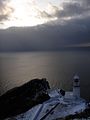 Chikyu Misaki in winter


Transportation[edit]
There are five JR Hokkaido stations in Muroran, starting from Higashi Muroran and ending in downtown Muroran, which can be used to access both Hakodate to the South West, and Sapporo to the North East.
- Muroran Main Line : Sakimori - Moto-Wanishi - Higashi-Muroran
- Muroran Branch Line : Higashi-Muroran - Wanishi - Misaki - Bokoi - Muroran
Economy[edit]
Japan Steel Works has its global headquarters in Muroran.
Education[edit]
Muroran houses one of the most prominent Marine Biology institutes in Japan, the Institute of Algological Research of Hokkaido University.
Universities[edit]
High schools[edit]
Public[edit]
- Hokkaido Muroran Sakae High School
- Hokkaido Muroran Shimizugaoka High School
- Hokkaido Muroran Tosho High School
- Hokkaido Muroran Technical High School
Private[edit]
- Hokkaido Ootani Muroran High School
- Kaisei Gakuin High School
Notable people[edit]
- Ikuta Toma - Actor, singer
- Natsumi Abe - idol, singer, actress. Hello! Project soloist. former Morning Musume member.
- Asami Abe - singer, actress. Younger sister of Natsumi Abe.
- Kaori Iida - singer. Hello! Project soloist. former Morning Musume member.
- Satoru Iwata - Previous CEO of Nintendo, Former HAL lab CEO and Game Designer
- Kyōko Tabe - Classical pianist
Twin towns and sister cities[edit]
 Shizuoka, Shizuoka, since 1976
 Knoxville, Tennessee, since 1991[6]
- Joetsu, Niigata, since 1995
References[edit]
- ^ US Department of State. (1906). A digest of international law as embodied in diplomatic discussions, treaties and other international agreements (John Bassett Moore, ed.), Vol. 5, p. 759.
- ^ The Asahi Shimbun. "
朝日新聞 デジタル:空襲 の記憶 風化 させぬ -北海道 -地域 ". www.asahi.com (in Japanese). Archived from the original on 14 April 2022. Retrieved 2022-04-13. - ^ Karan, Pradyumna (2010). Japan in the 21st Century. University Press of Kentucky. p. 327. ISBN 9780813127637.
- ^
観測 史上 1~10位 の値 (年間 を通 じての値 ). JMA. Retrieved February 18, 2022. - ^
気象庁 /平年 値 (年 ・月 ごとの値 ). JMA. Retrieved February 18, 2022. - ^ "City Directory". Sister Cities International. Archived from the original on 3 March 2016. Retrieved 25 March 2014.
External links[edit]
- Official Website (in Japanese)
| ||||||||||||
| ||||||||||||
| ||||||||||||
| ||||||||||||
| ||||||||||||
| ||||||||||||
| ||||||||||||
| ||||||||||||
| ||||||||||||
| ||||||||||||
| ||||||||||||
| ||||||||||||
| ||||||||||||
| ||||||||||||
| International | |
|---|---|
| National | |
| Geographic | |
| Academics | |