From Wikipedia, the free encyclopedia
Place in Hokkaido
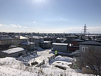 Nemuro City in Hokkaido.
Nemuro (根室振興局, Nemuro-shinkō-kyoku) is a subprefecture of Hokkaido Prefecture, Japan. Japan claims the southern parts of the disputed
Kuril Islands (known as the Northern Territories in Japan) as part of this subprefecture.
As of March 2009, the subprefecture has an estimated population of 84,035, and an area of 3406.23 km².
Nakashibetsu Airport, the easternmost airport in Japan, is located in the town of Nakashibetsu, Shibetsu District.
History[edit]
- November 1897: Nemuro Subprefecture established.
- November 1897: Shana Subprefecture established.
- December 1903: Shana Subprefecture and Nemuro Subprefecture merged.
- August 1945: Soviets occupied the Kuril Islands.
Geography[edit]
 Satellite photo of Hokkaido and the southern Kuril islands (Northern Territories)
Municipalities[edit]
Districts in the Northern Territories[edit]
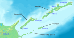 Nemuro Subprefecture is in north eastern Hokkaido. It shows the names of the claimed islands and districts (Northern Territories)
- Also known as the Southern Kuril Islands (administered by Russia, claimed by Japan; see Kuril Islands dispute):
 Nemuro Subprefecture is blue. The claimed islands and districts (Northern Territories) are grey.
Islands[edit]
Mergers[edit]
External links[edit]
43°19′49″N 145°35′04″E / 43.33038°N 145.584389°E / 43.33038; 145.584389


