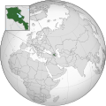
File:Armenia (orthographic projection).svg
Appearance

Size of this PNG preview of this SVG file: 553 × 553 pixels. Other resolutions: 240 × 240 pixels | 480 × 480 pixels | 768 × 768 pixels | 1,024 × 1,024 pixels | 2,048 × 2,048 pixels.
ʻAsi ʻa e faitā auiiki ((Faile SVG, lau pē 553 × 553 meʻaʻata, ko e faile hono lahi: 517 KB))
Hisitōlia ʻo e faile
Lomiʻi ha ʻaho/taimi ki he vakai ʻo e faile naʻe ʻi ai he taimi ko iá.
| ʻAho/Taimi | ʻAtasiʻi | Hono lahi | ʻEtita | Fakamatala | |
|---|---|---|---|---|---|
| taka | 19:03, 20 Mē 2021 |  | 553 × 553 (517 KB) | LightningComplexFire | Reverted to version as of 22:55, 23 February 2017 (UTC) Armenia does not recognize Kosovo nor Somaliland |
| 09:44, 13 Nōvema 2020 |  | 553 × 553 (650 KB) | That random man | Reverted to version as of 22:46, 2 May 2014 (UTC) kosovo is a real country and also somaliland is a country too | |
| 22:55, 23 Fēpueli 2017 |  | 553 × 553 (517 KB) | Kumasojin | Reverted to version as of 16:42, 4 May 2015 (UTC) | |
| 22:54, 23 Fēpueli 2017 |  | 1,280 × 1,280 (11 KB) | Kumasojin | test | |
| 16:42, 4 Mē 2015 |  | 553 × 553 (517 KB) | Flappiefh | Fixed position of zoom square. | |
| 15:44, 31 Maʻasi 2015 |  | 553 × 553 (517 KB) | Flappiefh | Fixed Somalia and removed Kosovo. | |
| 22:46, 2 Mē 2014 |  | 553 × 553 (650 KB) | Kentronhayastan | Made dotted lines thicker and more spaced to prevent them from looking like solid lines in lower resolutions. | |
| 18:26, 2 Mē 2014 |  | 553 × 553 (649 KB) | Kentronhayastan | Put lakes layer of mini-map below the border lines. | |
| 18:23, 2 Mē 2014 |  | 553 × 553 (635 KB) | Kentronhayastan | Updated map to new standard (lighter shade of grey and South Sudan added). | |
| 17:10, 27 Nōvema 2011 |  | 550 × 550 (579 KB) | Kentronhayastan | Although I understand the logic behind adding the lines and extending the shading, I find it doesn't make it look better. This way, it feels less cluttered and cleaner, and it makes its point as clearly as with the lines. |
Faitā fehokotaki
ʻOku fehokotaki ʻa e ngaahi peesi ki he failé ni:
Global file usage
The following other wikis use this file:
- Usage on ady.wikipedia.org
- Usage on af.wikipedia.org
- Usage on ami.wikipedia.org
- Usage on arc.wikipedia.org
- Usage on ar.wikipedia.org
- أرمينيا
- بوابة:أرمينيا/واجهة
- قائمة الدول ذات السيادة والأقاليم التابعة في آسيا
- مستخدم:جار الله/قائمة صور مقالات العلاقات الثنائية
- العلاقات الأرمنية الأمريكية
- العلاقات الأرمينية الأنغولية
- العلاقات الأرمينية الكورية الجنوبية
- العلاقات الأرمينية الإريترية
- العلاقات الأرمنية السويسرية
- العلاقات الأرمنية الألمانية
- العلاقات الأرمينية الليختنشتانية
- العلاقات الأرمينية البوليفية
- العلاقات الأرمينية الموزمبيقية
- العلاقات الأرمينية الألبانية
- العلاقات الأرمينية البلجيكية
- العلاقات الأرمينية الإثيوبية
- العلاقات الأرمينية البيلاروسية
- العلاقات الأرمنية الطاجيكية
- العلاقات الأرمنية الروسية
- العلاقات الأرمنية الرومانية
- العلاقات الأرمنية الأرجنتينية
- العلاقات الأرمينية الغامبية
- العلاقات الأرمنية القبرصية
- العلاقات الأرمينية السيراليونية
- العلاقات الأرمينية النيبالية
- العلاقات الأرمينية الليبيرية
- العلاقات الأرمينية التشيكية
- العلاقات الأرمينية الميانمارية
- العلاقات الأرمنية الكندية
- العلاقات الأرمينية الزيمبابوية
- العلاقات الأرمنية الإسرائيلية
- العلاقات الأرمينية البالاوية
- العلاقات الأرمينية المالية
- العلاقات الأرمينية النيجيرية
- العلاقات الأرمينية اليمنية
- العلاقات الأرمينية الفانواتية
- العلاقات الأرمينية الغابونية
- العلاقات الأرمينية البنمية
- العلاقات الأرمينية الكوبية
- العلاقات الأرمنية الجورجية
- العلاقات الأرمينية التونسية
- العلاقات الأرمينية الكورية الشمالية
- العلاقات الأرمنية الهندية
- العلاقات الأرمنية اليابانية
- العلاقات الأرمنية الإيطالية
View more global usage of this file.


