SC2869 : Trains crossing at Ballasalla, 1971
taken 53 years ago, near to Ballasalla, Isle of Man
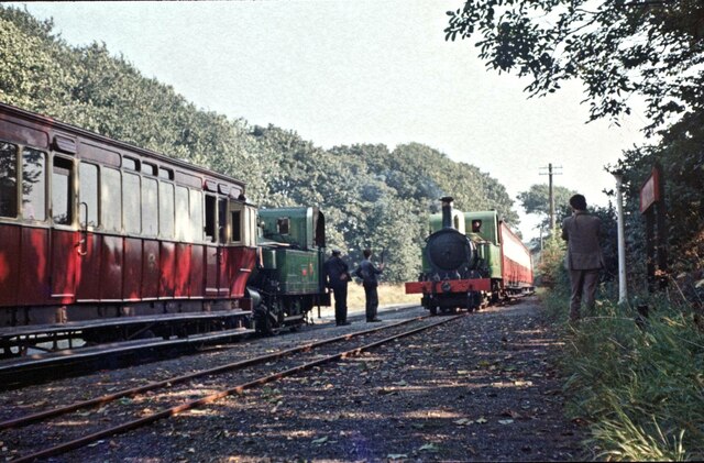
The railway between Douglas and Port Erin was opened in 1874 forming one part of an extensive 3ft gauge network that also served Peel and Ramsey. The railways were not originally intended primarily as tourist attractions but to provide a general transport service for the Isle of Man. In the 1960s, faced with heavy losses, the Peel and Ramsey lines were abandoned leaving only the current 15.3 mile route. Trains nowadays operate between March and November, taking one hour for the full journey. Original locomotives and rolling stock are used although other aspects of the railway including the level crossings have been modernised. The railway is owned by the IoM government and the islands Go Explore cards, giving access to all public transport, are valid on the trains.
![Creative Commons Licence [Some Rights Reserved]](https://s1.geograph.org.uk/img/somerights20.gif)
|
· Find out How to reuse this image ·
Share:
|
|||||
| Start a discussion on SC2869 | Suggest an update to this image | Contact the contributor | |||
 Map © Crown Copyright")
- Grid Square
- SC2869, 59 images (more nearby
 )
)
- Photographer
- Martin Tester (find more nearby)
- Date Taken
- Thursday, 9 September, 1971 (more nearby)
- Submitted
- Saturday, 20 July, 2024
- Geographical Context
- Place (from Tags)
- Primary Subject of Photo
- Subject Location
-
OSGB36:
 SC 2821 6992 [10m precision]
WGS84: 54:5.7852N 4:37.7126W - Camera Location
-
OSGB36: SC 2820 6990
- View Direction
- North-northeast (about 22 degrees)
Other Tags