|
History
 |
 |
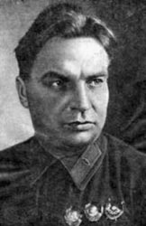
| Polar aviator Valery Chkalov. Image courtesy Ecoshelf. |
|
High Latitude Air Expeditions (1930s-1950s)
The use of aviation for ice studies
in the USSR began in 1924 with flights by Chukhnovsky over the
Kara Sea. In 1927 the first landings on pack ice in the White
Sea took place, and more or less regular ice reconnaissance
began in the 1930s, when navigation along the Northern Sea Route
became active. In June 1937, Valery Chkalov departed from an
airfield near Moscow on a transarctic flight lasting 63 hours
and 25 minutes. On this epic flight Chkalov crossed the White
Sea, Kola Peninsula, Frantz Josef Land, North Pole and Central
Arctic, landing on an airfield near Portland, Oregon. A month
later, a second even longer flight along this route was carried
out by Gromov. However, it wasn't until the successful drift
of the first "North Pole" station that the capabilities of aircraft
in Arctic research were fully appreciated. Airplanes could be
used not only to deploy cargo and ice camps, but also for short-term
landings on the ice and temporary field camps. Thus it became
possible to study different parts of the Arctic Ocean in one
season, allowing a much more comprehensive picture of the governing
processes.
In spring 1941 an expedition called "North" carried out three
flights from Wrangel Island to investigate one of the northeastern
regions of the Arctic Basin. At each landing site bottom sounding,
hydrographic, meteorological and geophysical measurements were
carried out. The success of the expedition established a new
method of field work. However, World War II immediately interrupted
the study and not until 1948 was "North" resumed.
Beginning in the 1950s, Soviet aircraft monitored the ice cover
in the Arctic every year through 1993 and contributed to supplying
other expeditions. The aircraft were also instrumental in erecting
a series of polar stations on the coast and islands and discovering
and mapping many new islands, capes, and bays. Bottom topography
was studied, and the Lomonosov, Mendeleev, Gakkel ridges, Nansen,
Makarov deeps were identified. Ice measurements were made, over
5500 oceanographic stations were acquired from drifting ice,
and tens of thousands of water samples were collected for chemical
analysis.
Reference:
Armstrong, T., The Russians in the Arctic, Methuen and
Co., London, 182 pp., 1958.
 Previous Chapter
Next Chapter

|


