
Mount Bromo is one of the major tourist site visited all of in Indonesia. The Mount Bromo is located in Bromo Tengger Semeru National Park. It is usually always in the ‘must go’ list to most traveler who visits to its host country; unless you’re not coming to Java at all.

Among many, three particular routes are popular to approach Mount Bromo from the nearby known and popular cities. The most popular route is to come from Surabaya. Other commonly used ones are respectively from Malang or from Banyuwangi. In our case we went there from Surabaya. We were living in Gubeng Suburb of Surabaya. We took a bus to Purabaya station. From Purabaya inter-city bus terminal we hopped into a standard non air-con bus which cost 12000 Indonesian Rupaiyas. It took us through a picturesque three hours drive to leave us into the district bus station of Probolinggo. Probolinggo is considered as one of the base towns to opt Mount Bromo and its surrounding areas. Transfer in minivans and larger version of tuktuks take you to the village of Camaro Lawang for about 30000 Indonesian Rupaiyas. We went there the day before Eid holidays so we kind of ran out of options and ended up paying 65000 Rupaiyas each. Another thrilling and roughly driven couple of hours took us sharp into some two thousand plus meters up. It was losing its brightness as we stood into the view point in the Camaro Lawang Village. We decided not to pay the National Park Entrance free which is 300,000 (Three Hundred Thousand it is) and take a route usually only used by the native. We climbed down for about 200 meters before getting down to starting of something they called is a ‘Sea of Sands’. There we saw a canal which looked like lava flew through it. Not sure if it carried lava but it definitely didn’t look like it had water flowing in it. It is extremely hard to explain what you can see through your eyes. The landscape is stunningly magnificent and the ground looks pretty much alien. It is more likely to look like an alien planet landscape than on earth.

We started our walk and it was now getting cold. By the time we reached to the temple on the base of Mount Batok. It is good that I tell you something which many doesn’t know or gets know much later than when they visit. Commonly, mount Batok is mistaken as Mount Bromo.
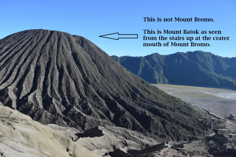
Whereas mount Batok is the curved green steep peak, Mount Bromo has a considerably larger lava mouth and is generally greyish in color. To make it more clear, Mount Bromo is not the green one, it is the grey one which exarts burned lava flakes. The one that has stairs is mount Bromo. The Brahma temple at the base of Mount Batok might have contributed to the confusion since Mount Bromo has been named after the the Hindu God Brahma.

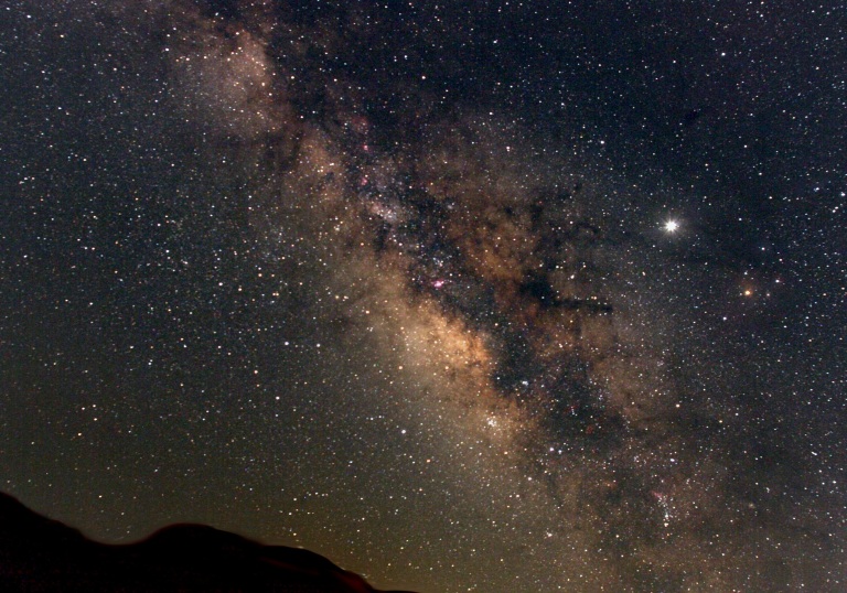
We walked for about 30 minutes to get ourselves to the base of Mount Bromo. With me, were Toine from Holland and Satwik from India. Toine, I stayed in the same hostel in Gubeng and we met Satwik on the minivan from Probolinggo. Toine went up while I and Satwik stood there in the midway to the crater mouth. The stars were looking like a big plate of lights. The milky way galaxy was brilliantly seen clear on the south eastern corner of the sky.
Then we realized that we were getting a strong smell. Initially which we believed to be the smell of sulfur, turned out to be from the ashes that are coming out of the crater mouth. We were all pretty much covered in ashes by the time Toine came back. His condition of course being the worst of it, we started out journey back up. There was no one around us in some 2-3 kilometers. You can sense a strong presence of your soul as you walk by the sea of sand to the trail up to the town where we kept out van waiting which would take us back to the Probolinggo town again.
It wasn’t very easy to walk in complete darkness. The only thing which was guiding was a mobile telecom tower which we saw as we started walking down. Of course the tower wasn’t visible but it’s light was. We took about an hour before we could get back up. Satwik was carrying his entire hiking bag which weighted more than 20 kilos I think. Poor, he had to carry that all the way up and down. We immediately hopped into our vehicle and left for the town.
Practical Advice:
Don’t rush and come back. We missed a stunning view of the mountains and the craters in the morning. Nonetheless, you can always spend an hour just by looking at the sky full of stars. Accommodations tart from 250,000-300,000 Indonesian Rupaiyas for a double room with very basic sleeping and storing facilities.

Mount Bromo can get really cold if it rains. So do take your preparation to face up the temperature fall. It is more than 2000 meters. It is always a good idea to bring in heavy warm cloths and wind-stoppers for a cozy walk.
When you are staying over the night at the Camaro Lawang village, you have to pay the entrance fee of the Mount Bromo National Park. In the morning, you can walk down and up all the way to the crater mouth or you can hire a four wheeler to take you up there effortlessly. Some hike down till the edge of sea of sands and then take horse to get up to the crater mouth. It is a very popular site for sunrise as the reflection of the early orange-ish sun reflects on top of mount Batok which creates a magnificent landscape. Clouds will always add up with a different decoration every day.
Other Good Places Around:
B29: There is another peak which is higher than Mount Bromo or Batok nearby. It is called the B29 Peak and is a common campground of backpackers. It offers a completely different landscape than that of Mount Bromo and surrounding. This area is greener and I believe is under a restricted area. But it is okay as an individual but they may deny to let you camp if you’re in large groups. Complete legal permits do cost a good amount of bucks but I’ve talked to many who said they ditched it and just camped for a couple of days without anyone hassling them. it still worths the view. You can always find a lonely spot but you are very likely to encounter a few other campers on your way up or down. Usually take a full day hike from Camaro lawang to B29 peak.
Coban Sewu Waterfall: Located about some 20 kilometers away from Mount Bromo Tengger. It is closer towards and from the large town of Malang. It is a massive waterfall which has got quite a few of different streams which gives it a majestic view both from the base and from above alike. The streams falling aprt from the clif side is something great to observe early in the morning. If you are nature, go for it. Definitely recommended from my point of view.
Madakaripura Waterfall: Madakaripura Waterfall is geographically closer to Bromo than it is through the roads via Probolinggo. You can contact the local small agencies to get you hooked up with other tourists who are going for it.
A typical tour agent will ask for 1.5 million Indonesian Rupaiyas (That’s about $115!) for a day trip. You can very well do it independently within 150,000-200,000.
Caution: Mount Bromo is pretty active. The last time it erupted was in 2015. It has regularly erupted in the last decade with a regular interval of 1-2 years. Do check on any possible notice for eruption and avoid staying close to Bromo during those days as the insanely beautiful nature up here can be unstoppably devastating.
You can forward your queries in the comment section via email at anik0504@hotmail.com
Photo Credits: Satwik Pandey, Mehnaz Ahmed Parisa and Nefartitee Ahmed.
