Category:Dyserth
Aller à la navigation
Aller à la recherche
village au Royaume-Uni   | |||||
| Téléverser des médias | |||||
| Prononciation (fichier son) | |||||
|---|---|---|---|---|---|
| Nature de l’élément | |||||
| Lieu | Denbighshire, pays de Galles | ||||
| Population |
| ||||
| Superficie |
| ||||
 | |||||
Cymraeg: Pentref canolig ei faint yn Sir Ddinbych, gogledd-ddwyrain Cymru, yw Diserth (ffurf Saesneg: Dyserth). Poblogaeth 2566 (Cyfrifiad 2001). Mae'n gorwedd ychydig o filltiroedd i'r de o Brestatyn ac i'r dwyrain o dref Rhuddlan.
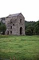
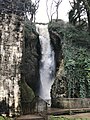
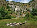
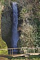
English: Dyserth is a village in Denbighshire, Wales. Population : 2,566 (United Kingdom Census 2001). Its main features are the extensive quarrying remains, its waterfalls, railway line (former LNWR, closed in 1930, and now footpath), and mountain (Moel Hiraddug).
Sous-catégories
Cette catégorie comprend 5 sous-catégories, dont les 5 ci-dessous.
Média dans la catégorie « Dyserth »
Cette catégorie comprend 125 fichiers, dont les 125 ci-dessous.
-
 5151 Curve - geograph.org.uk - 2191188.jpg 4 000 × 3 000 ; 5,87 Mio
-
 A domestic cow (Bos taurus) in a field, near Denbigh and Flintshire.jpg 4 608 × 2 128 ; 5,21 Mio
-
 A steep stile on Offa's Dyke Path - geograph.org.uk - 2056963.jpg 640 × 480 ; 107 kio
-
 Afon Ffyddion - geograph.org.uk - 6362921.jpg 4 000 × 3 000 ; 2,87 Mio
-
 Afon Ffyddion - geograph.org.uk - 658197.jpg 480 × 640 ; 136 kio
-
 Afon Ffyddion, Dyserth - geograph.org.uk - 5767026.jpg 1 280 × 851 ; 499 kio
-
 Afon Ffyddion, Dyserth - geograph.org.uk - 672621.jpg 480 × 640 ; 126 kio
-
 Arable field next to the Offa's Dyke path - geograph.org.uk - 6155499.jpg 1 024 × 683 ; 227 kio
-
 Autumn at the Graveyard.jpg 1 664 × 2 496 ; 3,43 Mio
-
 Bench beside a cycleway - geograph.org.uk - 2631405.jpg 640 × 480 ; 196 kio
-
 Bodrhyddan Hall - geograph.org.uk - 29588.jpg 448 × 336 ; 39 kio
-
 Bodryhyddan Old Park - geograph.org.uk - 5584525.jpg 1 280 × 960 ; 1,27 Mio
-
 Bridge on the cycleway - geograph.org.uk - 2631407.jpg 640 × 480 ; 177 kio
-
 Capel Dyserth Chapel - geograph.org.uk - 3840876.jpg 1 024 × 667 ; 103 kio
-
 Capel Dyserth Chapel - geograph.org.uk - 6059570.jpg 4 000 × 3 000 ; 2,68 Mio
-
 Cereal crop by Llewerllyd Farm - geograph.org.uk - 3577901.jpg 1 024 × 768 ; 154 kio
-
 Chalets below Graig Fawr - geograph.org.uk - 2748473.jpg 640 × 480 ; 142 kio
-
 Clive Shaft engine house, Talargoch Mine - geograph.org.uk - 674085.jpg 412 × 640 ; 73 kio
-
 Clive Shaft engine house, Talargoch mine, Dyserth – 1 - geograph.org.uk - 6150707.jpg 883 × 1 280 ; 447 kio
-
 Clive Shaft engine house, Talargoch mine, Dyserth – 2 - geograph.org.uk - 6150720.jpg 906 × 1 280 ; 484 kio
-
 Clive Shaft engine house, Talargoch mine, Dyserth – 3 - geograph.org.uk - 6150722.jpg 854 × 1 280 ; 342 kio
-
 Clive Shaft engine house, Talargoch mine, Dyserth – 4 - geograph.org.uk - 6150726.jpg 853 × 1 280 ; 259 kio
-
 Clive Shaft engine house, Talargoch mine, Dyserth – 5 - geograph.org.uk - 6150728.jpg 1 280 × 853 ; 482 kio
-
 Clive Shaft engine house, Talargoch mine, Dyserth – 6 - geograph.org.uk - 6150731.jpg 853 × 1 280 ; 542 kio
-
 Crane from Dyserth Railway (enhanced).jpg 960 × 720 ; 169 kio
-
 Cwm Road on the outskirts of Dyserth - geograph.org.uk - 5987244.jpg 4 000 × 3 000 ; 3,51 Mio
-
 Cwm Road, Dyserth - geograph.org.uk - 5987245.jpg 4 000 × 3 000 ; 3,95 Mio
-
 Datestone, limekiln, Ffordd y Foel, Dyserth - geograph.org.uk - 6150672.jpg 1 280 × 853 ; 530 kio
-

-
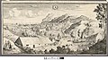 Disert.jpeg 800 × 449 ; 175 kio
-
 Dyserth - geograph.org.uk - 5767053.jpg 1 280 × 851 ; 694 kio
-
 Dyserth - geograph.org.uk - 658201.jpg 640 × 480 ; 84 kio
-
 Dyserth Falls - geograph.org.uk - 6369674.jpg 810 × 1 080 ; 252 kio
-
 Dyserth Falls - Northern View from the Top - geograph.org.uk - 2022169.jpg 640 × 640 ; 317 kio
-
 Dyserth Quarry - site of Dyserth Castle - geograph.org.uk - 6205823.jpg 1 024 × 768 ; 1,35 Mio
-
 Dyserth Waterfall - geograph.org.uk - 2306500.jpg 856 × 1 280 ; 349 kio
-
 Dyserth Waterfall - geograph.org.uk - 4392069.jpg 480 × 640 ; 113 kio
-
 Dyserth Waterfall - geograph.org.uk - 5766999.jpg 851 × 1 280 ; 481 kio
-
 Dyserth Waterfall - geograph.org.uk - 6205827.jpg 565 × 800 ; 598 kio
-
 Dyserth Waterfall Shop - geograph.org.uk - 672618.jpg 640 × 435 ; 90 kio
-
 Dyserth Waterfalls - geograph.org.uk - 4392060.jpg 640 × 480 ; 120 kio
-
 Dyserth ^ District Field Club - anniversary bench - geograph.org.uk - 2307779.jpg 1 280 × 856 ; 386 kio
-
 Dyserth, postbox № LL18 52, Waterfall Road - geograph.org.uk - 3605051.jpg 640 × 480 ; 75 kio
-
 Dyserth, red telephone box - geograph.org.uk - 3605041.jpg 640 × 480 ; 81 kio
-
 Dyserth, the waterfall - geograph.org.uk - 3605045.jpg 480 × 640 ; 119 kio
-
 Entrance to Graig Fawr - geograph.org.uk - 6370420.jpg 5 184 × 3 888 ; 3,95 Mio
-
 Farm road to Aberkinsey Farm - geograph.org.uk - 4890048.jpg 640 × 480 ; 89 kio
-
 Farmland near Dyserth - geograph.org.uk - 4890292.jpg 640 × 480 ; 60 kio
-
 Ffordd Uchaf Foel, Dyserth - geograph.org.uk - 6150686.jpg 1 280 × 853 ; 404 kio
-
 Ffordd y Foel, Dyserth - geograph.org.uk - 6150693.jpg 1 280 × 837 ; 407 kio
-
 Field edge footpath north of Dyserth - geograph.org.uk - 2748403.jpg 640 × 480 ; 44 kio
-
 Field with grazing sheep near Melidan - geograph.org.uk - 4890051.jpg 640 × 480 ; 108 kio
-
 Footpath from Dyserth to Marian Mills - geograph.org.uk - 6362918.jpg 4 000 × 3 000 ; 2,91 Mio
-
 Footpath sign to Dyserth Castle (site of) - geograph.org.uk - 2748436.jpg 640 × 480 ; 144 kio
-
 Graig Fawr trig point (153m) - geograph.org.uk - 6369706.jpg 5 184 × 3 888 ; 4,49 Mio
-
 Grass footpath on Graig Fawr - geograph.org.uk - 5987257.jpg 4 000 × 3 000 ; 3,59 Mio
-
 High Street (A5151) in Dyserth - geograph.org.uk - 5987247.jpg 4 000 × 3 000 ; 3,17 Mio
-
 High Street (A5151) in Dyserth - geograph.org.uk - 5987251.jpg 4 000 × 3 000 ; 3,06 Mio
-
 Horse at Bodrhyddan - geograph.org.uk - 5584431.jpg 1 280 × 960 ; 1,16 Mio
-
 In Fields south of Meliden - geograph.org.uk - 1336059.jpg 640 × 480 ; 120 kio
-

-
 Limekiln, Ffordd y Foel, Dyserth - geograph.org.uk - 6150670.jpg 817 × 1 280 ; 535 kio
-
 Llwybr Clawdd Offa - Offa's Dyke Path - geograph.org.uk - 3953763.jpg 3 264 × 2 448 ; 3,56 Mio
-
 Long Acre Cottages - geograph.org.uk - 4890291.jpg 640 × 480 ; 84 kio
-
 Lower Foel Road in Dyserth - geograph.org.uk - 29577.jpg 369 × 308 ; 26 kio
-
 Memorial bench on the Prestatyn-Dyserth Way - geograph.org.uk - 2748459.jpg 640 × 480 ; 167 kio
-
 No entry^ - geograph.org.uk - 6567959.jpg 4 000 × 3 000 ; 2,65 Mio
-
 Offa's Dyke Path - geograph.org.uk - 6566867.jpg 4 000 × 3 000 ; 2,21 Mio
-
 Offa's dyke path crossing a field - geograph.org.uk - 6155509.jpg 1 024 × 683 ; 170 kio
-
 Offa's Dyke Path passes through a wheat field - geograph.org.uk - 6566871.jpg 4 000 × 3 000 ; 2,82 Mio
-
 Offa's Dyke Path signpost - geograph.org.uk - 6566863.jpg 4 000 × 3 000 ; 2,89 Mio
-
 Old crane beside railway path at Dyserth - geograph.org.uk - 4755368.jpg 1 024 × 768 ; 290 kio
-
 Old Park - geograph.org.uk - 5584063.jpg 1 280 × 960 ; 1,16 Mio
-
 Ordnance Survey Flush Bracket G2911 - geograph.org.uk - 5988253.jpg 4 000 × 3 000 ; 4,07 Mio
-
 Ordnance Survey Fundamental Bench Mark - geograph.org.uk - 5988771.jpg 4 000 × 3 000 ; 4,9 Mio
-
 Parish Church of St Bridget, Dyserth - geograph.org.uk - 6369668.jpg 5 184 × 3 888 ; 3,21 Mio
-
 Part of the Prestatyn-Dyserth Way - geograph.org.uk - 2748421.jpg 640 × 480 ; 134 kio
-
 Part of the Prestatyn-Dyserth Way - geograph.org.uk - 2748445.jpg 640 × 480 ; 140 kio
-
 Path onto Graig Fawr hill - geograph.org.uk - 2748396.jpg 640 × 480 ; 74 kio
-
 Pen y Waen Cottage - geograph.org.uk - 6610906.jpg 3 755 × 2 450 ; 3,91 Mio
-
 Pick your colour of bus or coach - geograph.org.uk - 3996921.jpg 640 × 480 ; 74 kio
-
 Private Road to Llewerllyd Farm - geograph.org.uk - 4890247.jpg 640 × 480 ; 60 kio
-
 Railway Bridge facing Dyserth.jpg 1 024 × 685 ; 694 kio
-
 Reception committee on Graig Fawr - geograph.org.uk - 6369708.jpg 5 184 × 3 888 ; 3,77 Mio
-
 Red Lion, Dyserth - geograph.org.uk - 2306036.jpg 1 280 × 856 ; 158 kio
-
 Red Lion, Dyserth - geograph.org.uk - 2307350.jpg 1 280 × 856 ; 215 kio
-
 Rhydwen Farm Mews - geograph.org.uk - 32190.jpg 576 × 432 ; 54 kio
-
 Roadside protection for an O-S datum point - geograph.org.uk - 2748383.jpg 640 × 480 ; 130 kio
-
 Rocky Stream (enhanced).jpg 960 × 720 ; 208 kio
-
 Rocky Stream.jpg 4 896 × 3 672 ; 9,03 Mio
-
 Slightly overgrown stile on the Offa's Dyke Path - geograph.org.uk - 6567952.jpg 4 000 × 3 000 ; 2,89 Mio
-
 Step Up - geograph.org.uk - 2191193.jpg 3 000 × 4 000 ; 4,44 Mio
-
 Stile and hedge on Offa's Dyke path - geograph.org.uk - 6155502.jpg 1 024 × 683 ; 311 kio
-
 Stile near Ty Newydd - geograph.org.uk - 2631431.jpg 640 × 480 ; 128 kio
-
 Stile on Offa's Dyke Path near Bryniau - geograph.org.uk - 2748368.jpg 640 × 480 ; 99 kio
-
 Tafarn Newydd - New Inn, Dyserth - geograph.org.uk - 658202.jpg 640 × 480 ; 71 kio
-
 Tearooms at Dyserth waterfalls - geograph.org.uk - 29583.jpg 420 × 331 ; 48 kio
-
 The A5151 near Ty Newydd - geograph.org.uk - 6155494.jpg 1 024 × 683 ; 160 kio
-
 The cycleway-footpath to Prestatyn - geograph.org.uk - 2631415.jpg 640 × 480 ; 137 kio
-
 The Dyserth Falls - geograph.org.uk - 6135563.jpg 3 591 × 5 387 ; 6,81 Mio
-
 The Falls are fallen - geograph.org.uk - 6150718.jpg 1 280 × 853 ; 317 kio
-
 The grounds of Bodrhyddan Hall - geograph.org.uk - 5019585.jpg 5 184 × 3 456 ; 6,08 Mio
-
 The Old Crown, Meliden - geograph.org.uk - 4890227.jpg 640 × 480 ; 65 kio
-
 The Parterre at Bodrhyddan Hall - geograph.org.uk - 5025045.jpg 5 184 × 3 456 ; 7,62 Mio
-
 Tre-castell - geograph.org.uk - 5569166.jpg 640 × 447 ; 56 kio
-
 View from Ffordd Uchaf Foel, Dyserth - geograph.org.uk - 6150684.jpg 1 280 × 854 ; 305 kio
-
 View from Ffordd Uchaf Foel, Dyserth - geograph.org.uk - 6150685.jpg 1 280 × 853 ; 318 kio
-
 View towards Moel Hiraddug - geograph.org.uk - 5021145.jpg 4 184 × 2 789 ; 3,81 Mio
-
 Voel Coaches at Dyserth - geograph.org.uk - 3996083.jpg 640 × 480 ; 101 kio
-
 Voel Coaches depot - geograph.org.uk - 4890235.jpg 640 × 480 ; 66 kio
-
 Voel, Voel, Voel and Voel - geograph.org.uk - 4009920.jpg 640 × 480 ; 69 kio
-
 Wales Denbighshire Community Dyserth map.svg 512 × 773 ; 560 kio
-
 Western panorama to Snowdonia from Graig Fawr, Meliden 1951 - geograph.org.uk - 4226731.jpg 2 393 × 1 413 ; 1,48 Mio
-
 Westwards lies Graig Fawr - Meliden, Denbighshire - geograph.org.uk - 6712411.jpg 1 024 × 646 ; 104 kio
-
 Wheat fields and farmhouse - geograph.org.uk - 30647.jpg 512 × 384 ; 22 kio
-
 Y Bodunig - geograph.org.uk - 6059562.jpg 4 000 × 3 000 ; 2,21 Mio
-
 Y Llew Coch - The Red Lion, Dyserth - geograph.org.uk - 6369672.jpg 4 586 × 3 421 ; 2,31 Mio
-
 Y Llew Coch - The Red Lion, Dyserth - geograph.org.uk - 657675.jpg 640 × 480 ; 69 kio
-
 Cottages at Long Acre - geograph.org.uk - 30431.jpg 512 × 384 ; 36 kio
-
 Country lane at Dyserth - geograph.org.uk - 30712.jpg 512 × 384 ; 41 kio
-
 Disused farm building - geograph.org.uk - 26226.jpg 384 × 288 ; 26 kio
-
 Fields at Spital - geograph.org.uk - 25389.jpg 448 × 336 ; 25 kio
-
 Locals at Siamber Wen - geograph.org.uk - 27725.jpg 512 × 384 ; 50 kio
-
 Marian-bach farm near Cwm - geograph.org.uk - 542260.jpg 640 × 480 ; 86 kio
-
 Ruin near the Graig Park Hotel. - geograph.org.uk - 671382.jpg 480 × 640 ; 86 kio

_in_a_field,_near_Denbigh_and_Flintshire.jpg)


.jpg)


_-_geograph.org.uk_-_2748436.jpg)
_-_geograph.org.uk_-_6369706.jpg)

_in_Dyserth_-_geograph.org.uk_-_5987247.jpg)
_in_Dyserth_-_geograph.org.uk_-_5987251.jpg)


.jpg)


