Category:Lecumberry
Salta a ła navigasion
Salta a ła riserca
comun fransexo  .svg)  | |||||
| Carica un file multimediale | |||||
| Àudio co pronunsa | |||||
|---|---|---|---|---|---|
| Istansa de | |||||
| Liogo |
| ||||
| Popołasion |
| ||||
| Àrea |
| ||||
| Altesa sul mar |
| ||||
 | |||||
English: Lacumberry or Lekunberri is a village in the Basque province of Lower Navarre and administratively part of Pyrénées-Atlantiques department.
Euskara: Lekunberri Nafarroa Behereko herri bat da. Administratiboki Pirinio Atlantikoak departamenduan dago.
Soto-categorie
Sta categoria ƚa gà rento ste 5 soto-categorie, su 5 in tuto.
B
- Basque steles in Lecumberry (2 F)
E
M
- Maps of Lecumberry (3 F)
O
S
- Salbatore chapel, Irati (16 F)
File in te ła categoria "Lecumberry"
Sta categoria ła contien 24 file, indicai de seguito, so on totałe de 24.
-
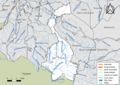 64327-Lecumberry-Routes-Hydro.png 3 507 × 2 480; 3,09 MB
-
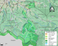 64327-Lecumberry-Sols.png 3 270 × 2 598; 3,24 MB
-

-
 Blason ville fr Lecumberry (Pyrénées-Atlantiques).svg 600 × 660; 62 KB
-
 Dans la vallée du ruisseau d'Egurgy, l'Espagne est à droite. - panoramio.jpg 3 264 × 2 448; 2,22 MB
-
 Egurgy - panoramio.jpg 2 862 × 1 747; 1,16 MB
-
 En remontant vers le plateau d'Iraty - panoramio.jpg 2 689 × 1 265; 843 KB
-
 Le Béhorléguy vu depuis Lecumberry.jpg 2 816 × 2 112; 1,08 MB
-
 Lecumberry - fronton - boîte à livres.jpg 1 536 × 2 048; 215 KB
-
 Lecumberry Fronton.JPG 3 872 × 2 592; 1,45 MB
-
 Lecumberry Laurhibar.jpg 2 000 × 3 008; 2,9 MB
-
 Lecumberry Maison.JPG 2 592 × 3 872; 2,27 MB
-
 Lecumberry Stèle1.JPG 3 872 × 2 592; 2,26 MB
-
 Lecumberry Stèle2.JPG 2 592 × 3 872; 2,3 MB
-
 Lekunberri kokapena.png 297 × 385; 75 KB
-
 Map commune FR insee code 64327.png 756 × 605; 104 KB
-
 Paysage versant sud-est, aux confins de la France et de l'Espagne - panoramio.jpg 3 264 × 2 448; 1,75 MB
-
 Pic d'Irau, sur le plateau à 1000m d'altitude - panoramio.jpg 3 264 × 2 448; 2,14 MB
-
 Population - Municipality code 64327.svg 475 × 355; 13 KB
-
 Route en mauvais état, dans la descente - panoramio.jpg 3 264 × 2 448; 2,05 MB
-
 Route en mauvais état, vers le ruisseau Xuruztako - panoramio.jpg 2 625 × 1 353; 873 KB
-
 Route en remontant sur le plateau d'Iraty - panoramio.jpg 3 264 × 2 448; 2,68 MB
-
 Tranquille vache... - panoramio.jpg 3 264 × 2 448; 4,1 MB
-
 Vers 960m d'altitude. Le massif d'Aranohegy (1250m) droit devant - panoramio.jpg 3 264 × 2 448; 2,46 MB


_droit_devant_-_panoramio.jpg)