Category:Maps of Macau
Jump to navigation
Jump to search
- Provinces of the People's Republic of China
- Anhui
- Fujian
- Gansu
- Guangdong
- Guizhou
- Hainan
- Hebei
- Heilongjiang
- Henan
- Hubei
- Hunan
- Jiangsu
- Jiangxi
- Jilin
- Liaoning
- Qinghai
- Shaanxi
- Shandong
- Shanxi
- Sichuan
- Yunnan
- Zhejiang
- Autonomous regions
- Guangxi
- Inner Mongolia
- Ningxia
- Tibet Autonomous Region
- Xinjiang
- Special administrative regions
- Hong Kong
- Macau
Wikimedia category | |||||
| Upload media | |||||
| Instance of | |||||
|---|---|---|---|---|---|
| Category combines topics | |||||
| Macau | |||||
special administrative region of China | |||||
| Pronunciation audio | |||||
| Instance of |
| ||||
| Part of |
| ||||
| Patron saint | |||||
| Location | PRC | ||||
| Legislative body | |||||
| Executive body | |||||
| Official language |
| ||||
| Anthem |
| ||||
| Currency | |||||
| Head of government |
| ||||
| Heritage designation | |||||
| Inception |
| ||||
| Highest point | |||||
| Population |
| ||||
| Area |
| ||||
| Elevation above sea level |
| ||||
| Religion or worldview |
| ||||
| Follows | |||||
| Top-level Internet domain | |||||
| Different from | |||||
| official website | |||||
 | |||||
Subcategories
This category has the following 13 subcategories, out of 13 total.
Pages in category "Maps of Macau"
The following 2 pages are in this category, out of 2 total.
Media in category "Maps of Macau"
The following 78 files are in this category, out of 78 total.
-
Administrative Division of Macau SAR.png 2,200 × 3,046; 643 KB
-
Administrative Division of Macau-ar.png 1,110 × 1,500; 262 KB
-
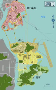
Administrative Division of Macau.png 1,110 × 1,500; 241 KB
-
AdministrativeDivisionOfMacao-Chinese.png 601 × 880; 133 KB
-
AdministrativeDivisionOfMacao-fr.svg 600 × 811; 235 KB
-
AdministrativeDivisionOfMacao-German.png 600 × 811; 155 KB
-
AdministrativeDivisionOfMacao-Portuguese.png 600 × 811; 155 KB
-
AdministrativeDivisionOfMacao.png 600 × 811; 150 KB
-
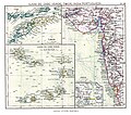
ATLAS JUSTUS PERTHES 14.jpg 4,349 × 3,845; 12.34 MB
-
BlankMap-Macau&HongKong.svg 744 × 1,052; 51 KB
-
Canton estuary.jpg 3,595 × 3,181; 1.14 MB
-
Centrostoricomacaogen.PNG 408 × 630; 8 KB
-
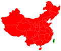
China Macau location map.svg 539 × 821; 69 KB
-
China Macau.svg 1,000 × 850; 207 KB
-
Colaoane 2015.png 1,110 × 1,500; 9.53 MB
-
Concelho das Ilhas.PNG 408 × 630; 9 KB
-
Concelho de Macau.PNG 408 × 630; 9 KB
-
Cotai 2015.png 1,110 × 1,500; 9.53 MB
-
Country-level map of the China region.svg 1,000 × 850; 58 KB
-
COVID-19 Outbreak Cases in Macau.png 446 × 688; 59 KB
-
COVID-19 Outbreak Cases in Macau.svg 539 × 821; 61 KB
-
Hong Kong and Macau, 1970.jpg 3,213 × 3,637; 1.56 MB
-
Hong Kong Location.png 400 × 202; 42 KB
-
Japan "discovered" in 1541 (3780460572).jpg 1,280 × 849; 147 KB
-
Macao Population Density, 2000 (6172442356).jpg 2,386 × 3,160; 650 KB
-
Macau (Macao)- Special Administrative Region - DPLA - 97092c920c08262c7e065c2e9d738a13.jpg 2,556 × 3,284; 5.73 MB
-
Macau administrative blank map.png 694 × 814; 79 KB
-
Macau administrative map-fr.svg 694 × 814; 1.04 MB
-
Macau city map China level 12.svg 2,064 × 2,088; 2.3 MB
-
Macau Constituency.svg 539 × 821; 30 KB
-
Macau consulates.png 1,425 × 625; 44 KB
-
Macau district map.jpg 1,710 × 1,830; 1.3 MB
-
Macau e Hong Kong.PNG 400 × 202; 46 KB
-
Macau Location.png 400 × 202; 40 KB
-
Macau Location.svg 1,270 × 640; 230 KB
-
Macau Map.jpg 1,215 × 1,708; 531 KB
-
Macau Parish Locator (template map).png 1,110 × 1,500; 123 KB
-
Macau peninsula 2015.png 1,110 × 1,500; 9.53 MB
-
Macau Population Density, 2000 (5457015603).jpg 2,507 × 3,265; 577 KB
-
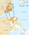
Macau Reclamation Map since 1921.png 1,518 × 1,713; 281 KB
-
Macau Statistical Districts Map 2019.png 1,829 × 2,369; 407 KB
-
Macau São Lourenço Location map.svg 1,344 × 2,047; 381 KB
-
Macau São Lázaro Location map.svg 1,344 × 2,047; 381 KB
-
Macau Trade Routes-ar.png 1,425 × 625; 62 KB
-
Macau Trade Routes.png 1,425 × 625; 58 KB
-
Macau Travel Alert.svg 2,754 × 1,398; 1.15 MB
-
Macau Water Transfer System Map.png 1,769 × 1,269; 510 KB
-
Macau-CIA WFB Map (2004).png 330 × 708; 15 KB
-
Macau-CIA WFB Map-ar.png 432 × 465; 133 KB
-
Macaucolourfulname.png 1,152 × 1,500; 90 KB
-
Macausmallmap1.gif 75 × 120; 753 bytes
-
MacauVisaFree.PNG 1,425 × 625; 56 KB
-
MacauWengHangMap1.jpg 490 × 390; 47 KB
-
Makaó-(Macau)-location-MAP-in-China-(Icelandic).jpg 1,092 × 851; 253 KB
-
Map AvenidaDeDemetrioCinatti Fire1990 zh-hant.svg 730 × 578; 275 KB
-
Map BecoDoCavalo Fire2003 zh-hant.svg 730 × 578; 56 KB
-
Map of Historic Centre of Macao, in Appendix of Macau Law 11 of 2013 (cropped).jpg 1,520 × 2,185; 372 KB
-
Map of Historic Centre of Macao, in Appendix of Macau Law 11 of 2013.pdf 1,262 × 1,800; 686 KB
-
MapOfMacauMunicipalities.svg 420 × 640; 38 KB
-
Neoguri(0801) Macau.png 442 × 650; 89 KB
-
Pas-Kaart van het in- en opkomen van de Rivier van Quantong.jpg 3,549 × 3,095; 4.92 MB
-
PAT - Hong Kong and Macau.gif 1,090 × 775; 136 KB
-
Pearl River Delta Area-ar.png 1,000 × 800; 175 KB
-
Pearl River Delta Area.png 1,000 × 800; 182 KB
-
Printable map macau china g-view level 12 eng svg.svg 1,854 × 1,749; 2.27 MB
-
Taipa 2015.png 1,110 × 1,500; 9.53 MB
-
Taiwan 1958 map detail, from- 1958 Chinas Offshore Islands (30884894575) (cropped).jpg 1,969 × 1,133; 1.45 MB
-
The Macao - Bocca Tigris - Canton approach.jpg 898 × 1,046; 773 KB
-
Txu-oclc-10552568-nf49-8-back.jpg 5,000 × 4,500; 3.76 MB
-
Txu-oclc-10552568-nf49-8.jpg 5,000 × 3,855; 6.15 MB
-
Viagem do Japao.png 1,021 × 656; 701 KB
-
World Factbook (1982) Macau.jpg 760 × 587; 101 KB
-
World Factbook (1990) Macau.jpg 421 × 544; 44 KB
-
中 华人民 共和 国 澳门特 别行政 区 行政 区域 图 (1999年 ).jpg 600 × 807; 244 KB
-
中 华人民 共和 国 澳门特 别行政 区 行政 区域 图.jpg 1,654 × 2,451; 429 KB
-
澳门
全 图.png 5,156 × 8,182; 6.06 MB


