Category:Maps of the history of Ireland
Jump to navigation
Jump to search
Countries of Europe: Albania · Andorra · Armenia‡ · Austria · Azerbaijan‡ · Belarus · Belgium · Bosnia and Herzegovina · Bulgaria · Croatia · Cyprus‡ · Czech Republic · Denmark · Estonia · Finland · France‡ · Georgia‡ · Germany · Greece · Hungary · Iceland · Republic of Ireland · Italy · Kazakhstan‡ · Latvia · Lithuania · Luxembourg · Malta · Moldova · Montenegro · Netherlands‡ · North Macedonia · Norway · Poland · Portugal‡ · Romania · Russia‡ · Serbia · Slovakia · Slovenia · Spain‡ · Sweden · Switzerland · Turkey‡ · Ukraine · United Kingdom
Limited recognition: Abkhazia‡ · Kosovo · South Ossetia‡ · Transnistria · Northern Cyprus‡
‡: partly located in Europe
Limited recognition: Abkhazia‡ · Kosovo · South Ossetia‡ · Transnistria · Northern Cyprus‡
‡: partly located in Europe
Subcategories
This category has the following 3 subcategories, out of 3 total.
E
P
Media in category "Maps of the history of Ireland"
The following 136 files are in this category, out of 136 total.
-
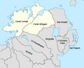
 Co Cavan 1584.png 779 × 568; 110 KB
-
 East Munster in the 16th Century (Confiscation in Irish history).png 1,390 × 1,368; 166 KB
-
 Ireland under Henry VIII. (Confiscation in Irish history).png 1,395 × 2,175; 162 KB
-
 419 of 'England under Stuart Rule, etc' (11248494064).jpg 1,267 × 1,916; 699 KB
-
 Achadh Leith-dheirg.jpg 6,525 × 3,700; 6.4 MB
-
 Achaidh Leithdeircc - Battle site - 331AD.jpg 960 × 536; 116 KB
-
 Airgialla-900.svg 633 × 825; 686 KB
-
 Bannside (Northern Ireland Parliament constituency).svg 683 × 559; 153 KB
-
 Bataille de l'ile de Toraigh.jpg 726 × 580; 209 KB
-
 Battle of Rathmines.jpg 4,914 × 5,438; 11.93 MB
-
 Battle of Tory Island-ES.svg 400 × 550; 109 KB
-
 Battle of Tory Island.png 399 × 556; 18 KB
-
 Battle of Tory Island.svg 400 × 550; 230 KB
-
 Britain.Deisi.Laigin.jpg 1,880 × 2,386; 788 KB
-
 British isles history v2.png 765 × 565; 75 KB
-
 Carlow-Kildare former Dáil constituency.png 728 × 928; 50 KB
-
 Cork and Youghal Railway (from Viceregal Commission 1906 map).jpg 474 × 267; 31 KB
-

-
 Dalriada.png 794 × 1,123; 1.42 MB
-
 Delbhna.jpg 989 × 411; 113 KB
-
 Domnall Gerrlámhach (map).png 1,023 × 1,301; 179 KB
-
 Domnall mac Murchada (map).png 574 × 1,000; 187 KB
-
 Early Scandinavian Dublin - Carlingford.svg 922 × 522; 213 KB
-
 Early Scandinavian Dublin - Dyflinn.svg 947 × 907; 75 KB
-
 Early Scandinavian Dublin - Elagh.svg 686 × 808; 201 KB
-
 Early Scandinavian Dublin - Moy.svg 873 × 1,213; 291 KB
-
 Early Scandinavian Dublin - North-East.svg 1,431 × 787; 159 KB
-
 Early Scandinavian Dublin - South-East.svg 762 × 789; 555 KB
-
 Early Scandinavian Dublin - South-West.svg 663 × 743; 913 KB
-
 Early Scandinavian Dublin - Southern Ui Neill.svg 1,181 × 741; 860 KB
-
 Early Scandinavian Dublin - Strangford.svg 671 × 804; 168 KB
-
 Early Scandinavian Dublin - Tirawley.svg 655 × 655; 195 KB
-
 Eoganachta.png 746 × 945; 682 KB
-
 Expédition d'Irlande Map.PNG 433 × 367; 11 KB
-
 Fingal mac Gofraid (map).png 1,288 × 2,245; 522 KB
-
 Flight of the Earls.jpg 597 × 645; 151 KB
-
 Gaels in Wales.jpg 800 × 1,015; 288 KB
-
 Gofraid Crobán (map).png 1,103 × 1,516; 287 KB
-
 Iireland-maps-historical-map1014-pt.svg 1,740 × 1,999; 202 KB
-
 Illas Britanicas (vèrs la fin dau sègle IX).png 801 × 956; 244 KB
-
 Illas Britanicas - Conquista normanda d'Anglatèrra.png 801 × 956; 282 KB
-
 Illas Britanicas - Guèrra Civila Anglesa (1642-1651).png 801 × 956; 329 KB
-
 Ireland 1173.jpg 850 × 1,080; 180 KB
-
 Ireland 1300.png 466 × 582; 9 KB
-
 Ireland 1450-es.svg 1,450 × 1,807; 615 KB
-
 Ireland 1450.png 466 × 582; 18 KB
-
 Ireland 1789.png 1,000 × 1,013; 210 KB
-
 Ireland According to Ptolemy.png 614 × 789; 105 KB
-
 Ireland early peoples and politics (Kerry cropped).gif 259 × 262; 37 KB
-
 Ireland early peoples and politics.gif 748 × 952; 312 KB
-
 Ireland early peoples and politics.svg 908 × 1,160; 44 KB
-
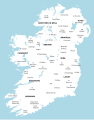
 Ireland medieval location map-es.svg 1,450 × 1,807; 667 KB
-
 Ireland medieval location map.svg 1,450 × 1,807; 666 KB
-
 Ireland protestants 1861-1991.gif 601 × 409; 11 KB
-
 Ireland1250 Breifne.png 466 × 582; 123 KB
-
 Ireland1898Administrative.png 3,000 × 3,533; 2.22 MB
-
 Ireland900-ko.png 2,060 × 2,630; 705 KB
-
 Ireland900.png 2,060 × 2,630; 512 KB
-
 Ireland900.svg 633 × 825; 1,009 KB
-
 Irelandmap1500.png 1,153 × 1,416; 683 KB
-
 IrelandMidIX-BeginningXI-es.svg 516 × 595; 553 KB
-
 IrelandMidIX-BeginningXI.svg 516 × 595; 1.27 MB
-
 IrelandVIII-FirstThirdIX-es.svg 774 × 892; 387 KB
-
 IrelandVIII-FirstThirdIX.svg 774 × 892; 1.19 MB
-
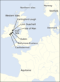
 Irish emigration to Great Britain.svg 675 × 1,180; 261 KB
-
 Irish Free State 1929.svg 450 × 456; 483 KB
-
 Irish Free State interwar.png 1,000 × 1,013; 185 KB
-
 Irish Republic.png 771 × 798; 102 KB
-
 Irland 1014.jpg 1,400 × 1,653; 283 KB
-
 IrlandaHaciaElAño900.svg 633 × 825; 1.36 MB
-
 John Speed Map of Leinster 1610.jpg 1,600 × 1,224; 2.61 MB
-
 Keltoi Tribes.PNG 500 × 556; 21 KB
-
 Kerry-Limerick West Dáil constituency 1921-1923.png 728 × 928; 49 KB
-
 Kildare-Wicklow Dáil constituency 1921-1923.png 728 × 928; 49 KB
-
 Kingdom of Breifne-900.svg 633 × 825; 687 KB
-
 Kingdom of Connacht-900.svg 633 × 825; 701 KB
-
 Kingdom of Ireland (1801).png 1,218 × 1,245; 39 KB
-
 Kingdom of Leinster-900.svg 633 × 825; 691 KB
-
 Kingdom of Mide-900-es.svg 633 × 825; 689 KB
-
 Kingdom of Mide-900-nb.svg 633 × 824; 538 KB
-
 Kingdom of Mide-900.svg 633 × 824; 542 KB
-
 Kingdom of Munster-900-ar.svg 633 × 825; 666 KB
-
 Kingdom of Munster-900.svg 633 × 825; 707 KB
-
 Kingdom of Osraige-900.svg 633 × 825; 685 KB
-

-
 Lordship of Ireland, 1300 (small).png 218 × 273; 14 KB
-
 Lordship of Ireland, 1300.png 436 × 546; 14 KB
-
 Lusmagh-parish-1024x715.jpg 1,024 × 715; 94 KB
-
 Macsleyney map.gif 704 × 496; 122 KB
-
 Macsleyney map2.gif 522 × 461; 77 KB
-
 MacWilliam Iochtar.png 860 × 796; 175 KB
-
 Map Gaels Brythons Picts patterns.png 778 × 829; 75 KB
-
 Map Gaels Brythons Picts.png 643 × 829; 66 KB
-
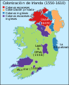
 Map of British plantations of Ireland, 1550–1610.png 466 × 565; 7 KB
-
 Map of Ireland (about 1100).svg 2,200 × 2,800; 309 KB
-
 Map of Ireland - Williamite War.gif 466 × 588; 100 KB
-
 Map of Ireland in 1609-es.GIF 466 × 582; 10 KB
-
 Map of Ireland in 1609-es.svg 681 × 834; 538 KB
-
 Map of Ireland in 1609.gif 466 × 582; 10 KB
-
 Map Olaf Guthfrithson-es.svg 1,109 × 771; 2.13 MB
-
 Map Olaf Guthfrithson-fr.svg 1,109 × 771; 2.02 MB
-
 Map Rail Ireland Viceregal Commission 1906.jpg 3,063 × 4,167; 897 KB
-
 MappaBritanniaeFacie.jpg 2,954 × 2,557; 837 KB
-
 MappaBritanniaeFacie3.png 1,100 × 936; 2.13 MB
-
 MappaBritanniaeFacie4.png 1,400 × 1,690; 4.25 MB
-
 Dioceses of Medieval Ireland.jpg 548 × 651; 111 KB
-
 Muintir Eolais Territory.png 412 × 534; 9 KB
-
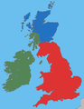
 Nations of the UK (with some flags).svg 512 × 384; 401 KB
-
 Nations of the UK-id.svg 781 × 574; 633 KB
-
 Nations of the UK.png 720 × 540; 108 KB
-
 Nations of the UK.svg 512 × 384; 247 KB
-
 Nine Years War January1600.png 794 × 1,035; 355 KB
-
 NorthernUiNeill.png 719 × 585; 88 KB
-
 Ogham map.png 1,155 × 1,279; 571 KB
-
 Old norse, ca 900.PNG 1,235 × 909; 100 KB
-
 Plantation of Ulster arm.png 631 × 380; 86 KB
-
 Plantation of Ulster.png 631 × 380; 105 KB
-
 Plantations in Ireland-hr.png 700 × 879; 200 KB
-
 Plantations in Ireland.png 700 × 879; 252 KB
-
 Ringfort distribution Ireland.png 2,355 × 2,805; 1.91 MB
-
 Sligo-Mayo East Dáil constituency 1921-1923.png 728 × 928; 49 KB
-
 Smerwick.1580.jpg 812 × 1,280; 1.18 MB
-
 Southern Ireland in the UK and Europe.svg 450 × 456; 1.15 MB
-
 The British Isles around 1300.png 1,731 × 2,456; 2.09 MB
-
 The Pale According to the Statute of 1488 edit.jpg 2,018 × 2,517; 823 KB
-
 The Pale According to the Statute of 1488.jpg 2,208 × 2,760; 2.48 MB
-
 Tomrair (map).png 868 × 1,178; 283 KB
-
 Treaty Ports (Ireland).png 2,000 × 2,545; 222 KB
-
 UK of Britain & Ireland in Europe.svg 2,045 × 1,720; 2.58 MB
-
 Viking Ireland.png 292 × 274; 8 KB
-
 Waterford-Tipperary East Dáil constituency 1921-1923.png 728 × 928; 49 KB
-
 Wicklow Boundary.png 610 × 680; 34 KB
-
 Www.wesleyjohnston.com-users-ireland-maps-historical-map1014-es.svg 1,740 × 1,999; 315 KB
-
 Www.wesleyjohnston.com-users-ireland-maps-historical-map1014.gif 466 × 582; 10 KB
-
 Www.wesleyjohnston.com-users-ireland-maps-historical-map1300.gif 466 × 582; 9 KB
-
 Írország betelepítése angol telepesekkel.PNG 700 × 879; 201 KB

.png)
.png)
.jpg)


.svg)


.jpg)


.png)
.png)


.png)


.png)

.png)

.png)


.gif)


.png)


.png)


.svg)


.svg)


.png)
.png)


