Category:SVG labeled maps of administrative divisions of Indonesia (location map scheme)
Jump to navigation
Jump to search
Countries of Asia: Afghanistan · Armenia‡ · Azerbaijan‡ · Bahrain · Bangladesh · Bhutan · Brunei · Cambodia · People's Republic of China · Cyprus‡ · East Timor · Egypt‡ · Georgia‡ · India · Indonesia‡ · Iran · Iraq · Israel · Japan · Jordan · Kazakhstan‡ · Kuwait · Kyrgyzstan · Laos · Lebanon · Malaysia · Maldives · Mongolia · Myanmar · Nepal · North Korea · Oman · Pakistan · Philippines · Qatar · Russia‡ · Saudi Arabia · Singapore · South Korea · Sri Lanka · Syria · Tajikistan · Thailand · Turkey‡ · Turkmenistan · United Arab Emirates · Uzbekistan · Vietnam · Yemen
Limited recognition: Abkhazia‡ · Northern Cyprus‡ · State of Palestine · South Ossetia‡
‡: partly located in Asia
Limited recognition: Abkhazia‡ · Northern Cyprus‡ · State of Palestine · South Ossetia‡
‡: partly located in Asia
Countries of Oceania: Australia · Fiji · Federated States of Micronesia · Marshall Islands · Nauru · New Zealand · Palau · Papua New Guinea · Samoa · Solomon Islands · Tonga · Tuvalu · Vanuatu
Other areas: Cook Islands · Hawaii · Niue – Partly: Indonesia
Other areas: Cook Islands · Hawaii · Niue – Partly: Indonesia


.svg)


_(Paris_zoom).svg)
.svg)
,_administrative_divisions_-_de_-_colored_(multizoom).svg)
_-_colored.svg)
.svg)
,_administrative_divisions_-_Nmbrs_(multizoom).svg)
,_administrative_divisions_-_de_-_colored.svg)
_-_de_-_colored.svg)

.svg)

.svg)

|
This page requires updating because: In 2022, the Papua provinces changed from 2 provinces to 6 provinces. Some maps in this category may be outdated. In doing so, you could add a timestamp to the page.
|
Media in category "SVG labeled maps of administrative divisions of Indonesia (location map scheme)"
The following 17 files are in this category, out of 17 total.
-
 Indonesia provinces 2022 - id.png 5,222 × 2,000; 1.64 MB
-
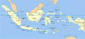
 Indonesia, administrative divisions - id.svg 982 × 450; 1.21 MB
-
 Indonesia provinces map-fr.svg 786 × 361; 689 KB
-
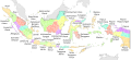
 Indonesia provinces map-he.svg 1,292 × 604; 529 KB
-
 Indonesia, administrative divisions - de - colored.svg 982 × 451; 1.48 MB
-
 Indonesia, administrative divisions - de - monochrome.svg 1,200 × 460; 1.53 MB
-
 Indonesia, administrative divisions - en - monochrome.svg 982 × 450; 909 KB
-
 Indonesia, administrative divisions - es - colored.svg 1,200 × 551; 1.15 MB
-
 Indonesia, administrative divisions - es - monochrome.svg 1,200 × 551; 778 KB
-
 Indonesia, administrative divisions - et - colored.svg 1,200 × 460; 1,022 KB
-
 Indonesia, administrative divisions - fr - monochrome.svg 1,322 × 620; 319 KB
-
 Indonesia, administrative divisions - mg - monochrome.svg 1,322 × 620; 319 KB
-
 Indonesia, administrative divisions - mk - monochrome.svg 1,322 × 620; 545 KB
-
 Indonesia, administrative divisions - Nmbrs - colored.svg 982 × 450; 948 KB
-
 Indonesia, administrative divisions - Nmbrs - monochrome.svg 1,200 × 460; 1.53 MB
-
 Indonesia, administrative divisions - th - colored.svg 1,200 × 460; 2.1 MB
-
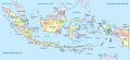
 Peta provinsi Indonesia.svg 1,876 × 861; 1.22 MB


