Category:Willow Palisade
Jump to navigation
Jump to search
a former massive barrier between Manchuria and Mongolia | |||||
| Upload media | |||||
| Instance of | |||||
|---|---|---|---|---|---|
| Location | |||||
| |||||
The Willow Palisade or Barrier (
Subcategories
This category has only the following subcategory.
Media in category "Willow Palisade"
The following 88 files are in this category, out of 88 total.
-

-
 Da Ming yu di tu LOC 2002626776-5.jpg 9,645 × 8,876; 13.12 MB
-
 Da Ming yu di tu LOC 2002626776-5.tif 9,645 × 8,876; 244.93 MB
-
 Guang yu tu - er juan LOC 2008623187-2.jpg 4,380 × 4,658; 4.55 MB
-
 Guang yu tu - er juan LOC 2008623187-2.tif 4,380 × 4,658; 58.37 MB
-
 Chunha daechong il ram jido early 1700.jpg 800 × 665; 145 KB
-
-
 Der Jesuiten-Atlas der Kanghsi-Zeit - China und die Aussenlaender LOC 74650033-1.jpg 9,211 × 7,454; 7.54 MB
-
 Der Jesuiten-Atlas der Kanghsi-Zeit - China und die Aussenlaender LOC 74650033-1.tif 9,211 × 7,454; 196.43 MB
-
 Der Jesuiten-Atlas der Kanghsi-Zeit - China und die Aussenlaender LOC 74650033-6.jpg 8,309 × 5,884; 5.66 MB
-
 Der Jesuiten-Atlas der Kanghsi-Zeit - China und die Aussenlaender LOC 74650033-6.tif 8,309 × 5,884; 139.88 MB
-

-

-
-
 Anville Nouvel atlas de la Chine - Page58 tartarie 1 leaotong.jpg 4,169 × 2,564; 4.28 MB
-
-
 Cartes particulières de la Tartarie chinoise - D'Anville - btv1b5963110z (01 of 12).jpg 5,824 × 3,872; 4.41 MB
-
 Cartes particulières de la Tartarie chinoise - D'Anville - btv1b5963111c (01 of 12).jpg 5,784 × 3,760; 3.81 MB
-
 CEM-44-La-Chine-la-Tartarie-Chinoise-et-le-Thibet-1734-Liaodong-2755.jpg 2,048 × 1,536; 1.57 MB
-
 CEM-44-La-Chine-la-Tartarie-Chinoise-et-le-Thibet-1734-NE-2571.jpg 2,560 × 1,920; 2.09 MB
-

-
-
 1740 map of China, published by Homann Heirs.jpg 12,726 × 14,291; 45.99 MB
-
 Ca. 1740 map of China, published by Homann Heirs.jpg 12,577 × 14,235; 40.47 MB
-
 Ca. 1740 map of China, published by Homannsche Erben.jpg 12,863 × 14,455; 32.53 MB
-
 AMH-8182-KB Map of China.jpg 2,400 × 2,104; 1.37 MB
-

-
 L'Empire de la Chine pour servir a L'histoire générale des voyages LOC 2006629393.jpg 6,810 × 5,064; 6.37 MB
-
 L'Empire de la Chine pour servir a L'histoire générale des voyages LOC 2006629393.tif 6,810 × 5,064; 98.67 MB
-
-
 AMH-7966-KB Map of China and Korea.jpg 2,400 × 2,241; 1.29 MB
-

-

-

-
-
 KKR-20 La CHINE avec la Korée et les Parties de la Tartarie.jpg 3,148 × 2,584; 1.1 MB
-
 Tatariae Sinensis mappa geographica 1749 24374665.jpg 13,080 × 7,036; 22.5 MB
-
 Carte de la Corée - Dheulan Sculp. - btv1b5963114m.jpg 2,928 × 4,392; 1.92 MB
-
 Carte de la Corée - par J.-B. d'Anville - btv1b8468520p.jpg 3,168 × 5,088; 2.63 MB
-

-

-

-
 Huang chao zhi sheng yu di quan tu - Lu ying sheng - btv1b52505943g.jpg 16,210 × 9,584; 23.59 MB
-

-
 프랑스의 독도지도1 copy.gif 361 × 461; 164 KB
-
 Map of Korea.jpg 800 × 600; 131 KB
-
 Da Qing fen sheng yu tu LOC 2002626726-1.jpg 5,280 × 4,534; 2.43 MB
-
 Da Qing fen sheng yu tu LOC 2002626726-1.tif 5,280 × 4,534; 68.49 MB
-
 L'Asie divisée en tous ses Etats 2.jpg 1,089 × 1,515; 376 KB
-
 Great Wall of China in Picaud 1763 Eurasia map.jpg 2,482 × 1,284; 548 KB
-
 A new & accurate map of China LOC 2006629424.jpg 7,154 × 5,799; 7.9 MB
-
 A new & accurate map of China LOC 2006629424.tif 7,154 × 5,799; 118.69 MB
-
 1770 Bonne Map of China, Korea, Japan and Formosa - Geographicus - China-bonne-1770.jpg 4,000 × 2,787; 3.09 MB
-

-

-
 Kitchen-22-Asia-Amur-Basin-2854.jpg 2,560 × 1,920; 2.05 MB
-
 1779 - Carte de l' Empire de la Chine avec la Tartarie Chinoise.jpg 7,144 × 5,918; 6.63 MB
-

-
 L'Empire de la Chine avec la Tartarie chinoise ; d'après l'atlas chinois. LOC 2006635530.jpg 11,680 × 8,183; 13.84 MB
-
 L'Empire de la Chine avec la Tartarie chinoise ; d'après l'atlas chinois. LOC 2006635530.tif 11,680 × 8,183; 273.45 MB
-
 Histoire des deux Indes-Atlas-d26-C08-Chine.png 3,147 × 2,329; 2.47 MB
-
 China, divided into its great provinces, and the Isles of Japan (NYPL b13919861-5207423).jpg 8,045 × 6,648; 44.32 MB
-

-

-
 Erdglobus aus Salem img04.jpg 4,288 × 2,848; 6.33 MB
-
 1784 D'Anville Wall Map of Asia - Geographicus - Asia-anville-1794.jpg 7,000 × 6,074; 11.94 MB
-
 China divided into provinces drawn from the best authorities LOC 2006629368.jpg 8,561 × 6,705; 11.12 MB
-
 China divided into provinces drawn from the best authorities LOC 2006629368.tif 8,561 × 6,705; 164.23 MB
-
 1806 Cary Map of Tartary or Central Asia - Geographicus - Tartary-cary-1806.jpg 5,000 × 4,569; 8.57 MB
-
 Zhi li ge sheng yu di quan tu - Zhang Zongjing - btv1b53103898v (17 of 69).jpg 5,102 × 4,405; 2.65 MB
-
 Zhi li ge sheng yu di quan tu - Zhang Zongjing - btv1b53103898v (20 of 69).jpg 5,118 × 4,427; 2.88 MB
-

-
 John-Tallis-1851-Tibet-Mongolia-and-Manchuria-33621.jpg 4,030 × 3,102; 12.64 MB
-
 John-Tallis-1851-Tibet-Mongolia-and-Manchuria-NE.jpg 2,100 × 1,400; 2.34 MB
-
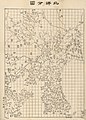
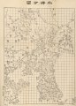
 Shengjing quan tu. LOC gm71005114.jpg 8,192 × 7,498; 6.89 MB
-
 Shengjing quan tu. LOC gm71005114.tif 8,192 × 7,498; 175.73 MB
-
 Bei yang fen tu. LOC gm71005226.jpg 5,184 × 7,236; 5.82 MB
-
 Bei yang fen tu. LOC gm71005226.tif 5,184 × 7,236; 107.32 MB
-
 Nan bei yang he tu. LOC gm71005215.jpg 5,106 × 7,122; 4.64 MB
-
 Nan bei yang he tu. LOC gm71005215.tif 5,106 × 7,122; 104.04 MB
-
 Huang chao zhi sheng di yu quan tu - btv1b531099218 (05 of 38).jpg 6,188 × 4,553; 4.05 MB
-
 Huang chao zhi sheng di yu quan tu - btv1b531099218 (06 of 38).jpg 6,188 × 4,553; 2.83 MB
-
 Letts-Popular-Atlas-1883-Russia-in-Asia-Chinese-Empire-etc-Liaoning-thumbnail.jpg 1,400 × 1,000; 448 KB
-
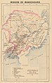 Mission de Mandchourie.jpg 1,589 × 2,560; 1.08 MB
-
 Tian xia zong yu tu. LOC 2002626780-1.jpg 3,847 × 3,193; 1.35 MB
-
 Tian xia zong yu tu. LOC 2002626780-1.tif 3,847 × 3,193; 35.14 MB
-
 Mandchourie méridionale.jpg 1,600 × 1,248; 652 KB
-
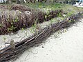 Willow wattle barrier.jpg 2,080 × 1,560; 787 KB
%27_(11298439315).jpg)


.jpg)


_de_la_Tartarie_chinoise_-_par_J.-B._d%27Anville_-_btv1b84686557_(1_of_6).jpg)
.jpg)
.jpg)


.jpg)
.jpg)


_(14782754404).jpg)


.jpg)


.jpg)


.jpg)
.jpg)
.jpg)


.jpg)
.jpg)


