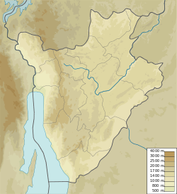
Ruhehe is the capital town of the Commune of Bugabira, in the Kirundo Province of Burundi.
Ruhehe | |
|---|---|
Town | |
| Coordinates: 2°31′53″S 30°04′14″E / 2.5314°S 30.0706°E | |
| Country | |
| Province | Kirundo Province |
| Commune | Bugabira Commune |
| Time zone | UTC+2 (Central Africa Time) |
Location
Ruhehe is roughly in the center of Bugabira Commune in the road leading north from Bugabira in Kirundo Commune to Kiyonza in the north of Bugabira Commune. It is northeast of Lake Gacamirindi.[1]
Development
A March 2021 report on the envirnmental and social impact of a project to develop schools in Ruhehe and other locations noted that a rainwater collection system would be needed at Ruhehe because it is unusual to have a public drinking water supply in the region, and even if available the network would not supply water.[2] The site of the school is 2 kilometres (1.2 mi) from the capital of Bugabira commune, and is owned by the commune. It would include six classrooms, an administrative block, two blocks of drainable latrines and rainwater sanitation works.[3]
References
- ^ Node: Ruhehe (1347150636).
- ^ Ndayizamba 2021, p. xvi.
- ^ Ndayizamba 2021, p. 2.
Sources
- Ndayizamba, Prudence (March 2021), Etude D'impact Environnemental Et Social Pour Les Travaux De Construction Des Infrastructures Scolaires Du Lycee Communal Cankuzo (Commune Cankuzo), De L'ecole Primaire Masama (Commune Nyamurenza), Ecole Fondamentale Carubambo, Ecole Technique Nyamurenza (Commune Nyamurenza), Ecofo Ruhehe (Commune Bugabira). (PDF) (in French), retrieved 2024-06-08
- "Node: Ruhehe (1347150636)", OpenStreetMap, retrieved 2024-06-20
