This article relies largely or entirely on a single source. (February 2017) |
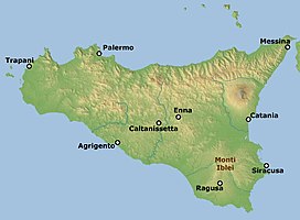
The Hyblaean Mountains (Sicilian: Munt'Ibblei; Italian: Monti Iblei; Latin: Hyblaei montes)[1] is a mountain range in south-eastern Sicily, Italy. It straddles the provinces of Ragusa, Syracuse and Catania. The highest peak of the range is Monte Lauro, at 986 metres (3,235 ft).
| Hyblaean Mountains | |
|---|---|
 Location of Monti Iblei. | |
| Highest point | |
| Elevation | 986 m (3,235 ft) |
| Coordinates | 37°06′58″N 14°49′13″E / 37.11611°N 14.82028°E |
| Geography | |
| Location | Province of Ragusa, Province of Syracuse, Sicily, Italy |
| Climbing | |
| Easiest route | mountain walk from the road at Buscemi |
History
editThe name derives from the Siculi king Hyblon, who gave a portion of his territory to Greek colonists to build the town of Megara Hyblaea.
Geology
editThe range is composed of white limestone rocks, characterized by Karst topography. Originally a plateau, rivers have eroded the landscape, forming numerous deep canyons. In the coastal area sandstone is also present. In some areas, such as that of Monte Lauro (once part of a submerged volcanic complex), volcanic rocks are also present. The hyblaean area is characterized by a high seismic risk.[2]
Landscape
editThe Hyblaean Mountains are characterized by gentle slopes, interrupted by sharp valleys. In the central area are numerous woods which are intermingled with dry stone walls of typical of south-eastern Sicily. The more populated coastal area is characterised by terraced hills with Mediterranean vegetation, rising up to a plateau cultivated by olive trees, vines, citrus fruit and almonds. Other crops include grain and maize.
Hyblaean Mountains host the archaeological remains of the medieval castles of Ferla, Buscemi and Cassaro. Their discovery is relatively recent and mainly due to the archaeological campaign held in the area from 2011 to 2013.[2]
Main sights
editMain attractions of the area include the Baroque towns of Ragusa, Modica and Palazzolo Acreide, the Necropolis of Pantalica and Cava Ispica.
Peaks
editThe main peaks of the Monti Iblei are:
- Monte Lauro 986 metres (3,235 ft)
- Monte Casale 910 metres (2,990 ft)
- Monte Arcibessi 907 metres (2,976 ft)
- Serra Brugio 870 metres (2,850 ft)
- Monte Raci 610 metres (2,000 ft)
- Monte Racello 530 metres (1,740 ft)
- Monti Climiti 410 metres (1,350 ft)
Rivers
editThe range is drained by several rivers, which flow into either the Mediterranean Sea or the Ionian Sea.
|
|
References
edit- ^ "Archived copy". Archived from the original on 2008-05-13. Retrieved 2008-07-23.
{{cite web}}: CS1 maint: archived copy as title (link) - ^ a b Santino Alessandro Cugno (2015). "Esperienze di archeologia pubblica nella Sicilia sud-orientale" [Public archaeology experiences in south-eastern Sicily] (PDF). Il Capitale Culturale: Studies on the Value of Cultural Heritage (in Italian) (11): 251–274. doi:10.13138/2039-2362/1026. ISSN 2039-2362. Archived from the original on April 27, 2016.
- ^ "Fiume Anapo". Fiumi.com. Retrieved 2017-02-28.
- ^ "Fiume Irminio". Fiumi.com. Retrieved 2017-02-28.
- ^ "Fiume Tellaro". Fiumi.com. Retrieved 2017-02-28.
- ^ "Fiume Cassibile Cava Grande". Fiumi.com. Retrieved 2017-02-28.
- ^ "Fiume Ippari". Fiumi.com. Retrieved 2017-02-28.
- ^ "Torrente Modica". Fiumi.com. Retrieved 2017-02-28.
- ^ "Torrente Tellesimo". Fiumi.com. Retrieved 2017-02-28.
Bibliography
edit- Grandi Montagne - Sicilia. 2007.
