Mount Wakakusa (
| Mount Wakakusa | |
|---|---|
 | |
| Highest point | |
| Elevation | 342 m (1,122 ft)[1] |
| Listing | Mountains of Japan |
| Coordinates | 34°41′28″N 135°51′15″E / 34.69103°N 135.85419°E[1] |
| Geography | |
 Mount Wakakusa Location on Japan | |
| Location | Nara, Japan |
| Parent range | Kasagi Mountains |
On the fourth Saturday of January year, the dead grass of Mount Wakakusa is burned in an annual festival known as Yamayaki (
Yamayaki festival
editOn the fourth Saturday of January year, the dead grass of Mount Wakakusa is burned in an annual festival known as Yamayaki (
The burning of Mount Wakakusa as part of the annual festival can be seen from the city of Nara and many other locations in the northern part of the Nara Basin. It can be viewed at a further distance from the Aeon Mall Yamato-kōriyama multilevel parking lot, and from buildings in the cities of Kashihara and Gose. The blazing hillside is also visible from Mount Kongō, Mount Ikoma, Hōzan-ji and the ryokan street directly below it. The most popular viewing locations, however, include Nara Park near the five-storied pagoda of Kōfuku-ji, Oike pond near Yakushi-ji, and Heijō Palace.
Gallery
edit-
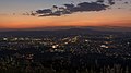
 Overlooking Nara
 -
 Night view of Nara
 -
 Viewed from Heijō Palace (with Mt Kasuga on the right)
 -
 Yakushiji and Mount Wakakusa seen from Oike pond
 -
 Burning the dead grass, with accompanying fireworks
 -
 Burning the dead grass (animation)


References
edit- ^ a b "Topographic map of Mount Wakakusa". opentopomap.org. Retrieved 2023-06-20.
- ^ "A centuries-old ritual that sets a mountain on fire". Japan National Tourism Organization.
External links
editThis Nara Prefecture location article is a stub. You can help Wikipedia by expanding it. |