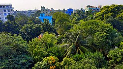
Narsingdi (Bengali: নরসিংদী) is a city and headquarters of Narsingdi District in the division of Dhaka, Bangladesh.[2] The Dhaka–Sylhet highway connects Narsingdi with the capital and other major cities. The district is located between 24.1344° N and 90.7860° E. It is surrounded by Tarowa on the north, Hazipur on the east, the Meghna River on the south, and by Chouwala and Kamargaon on the west.[3] Narsingdi is one of the most important cities for the garment industry. The city is famous for its textile craft industry.
Narsingdi
নরসিংদী | |
|---|---|
City and Municipality | |
 drone view city of Narsingdi | |
| Coordinates: 23°55′23″N 90°42′44″E / 23.92306°N 90.71222°E | |
| Country | |
| Division | Dhaka |
| District | Narsingdi |
| Upazila | Narsingdi Sadar |
| Government | |
| • Type | Mayor–Council |
| • Body | Narsingdi Municipal Corporation |
| Area | |
| • Total | 14.8 km2 (5.7 sq mi) |
| Population | |
| • Total | 180,699 |
| • Density | 12,000/km2 (32,000/sq mi) |
| Time zone | UTC+6 (Bangladesh Time) |
| Postal code | 1600 |
| National Dialing Code | +880 |
History
editThe name Narsingdi, which translates as "lion man" in Bangla, is named after an ancient king who was believed as strong as a lion.[3]
Modern history
editThe district became a district in 1984, and before that it was a subdivision under the greater Dhaka district. The city is famous for its textile craft industry. Narsingdi is one of the most important cities for the garment industry.
Haunted house victim
editThe Balapur Zamindar Bari in Paikarchar union is over a couple of hundred years old and previously belonged to a Hindu tax collector erstwhile Dhaka district named Jagat Das.The whole mansion was built with decorations and motifs on all sides. Each of the rooms is fitted with mosaic and tiles. The doors and windows were also decorated. There are twin ponds called Bhobani and Rukshar, and rumor has it that there used to be a Hindu cremation ground in the spot of one of the ponds. With the land apparently being haunted by evil spirits, the whole compound is infamous among the locals.[4]
Demographics
editAccording to the 2011 Bangladesh census, Narsingdi Municipality had 32,361 households and a population of 146,115. 30,982 (21.20%) were under 10 years of age. Narsingdi had a literacy rate (age 7 and over) of 67.78%, compared to the national average of 51.8%, and a sex ratio of 970 females per 1000 males.[5]
Education
editThere are 27 colleges and one Ib diploma program school in the Upazila, most located in Narsingdi Those inside the upazila include: Narsingdi Govt. College, Narsingdi Science College, Narsingdi Independent College, Narsingdi Govt. Mohila College, Abdul Kadir Mollah City College, Abdul Kadir Molla International School (IB) School, Baburhat Green Field College, Farida Hashem International College, Jaj Bhuiyan College, Madhabdi College, Madhabdi Digital College, Narsingdi Central College, Narsingdi Imperial College, Narsingdi Prime College, Narsingdi Udayon College, Scholastica Model College, and Shilmandi Adarsha College.
Notable secondary schools of the city and the district include Brahmondi K.K.M Govt High School (1946), NKM High School and Homes (2008), Satirpara K.K. Institution School & College (1901), Narsingdi Govt. Girl's High School (1934), Balapur Nabin Chandra High School (1905), Charsindur Govt. High School (1919), Shibpur Govt. Pilot Model High School (1918) and Sir K.G Gupta High School (1919).
One special school in the city is one of the most prestigious schools in Bangladesh: Abdul Kadir Molla International School. It has two of the most prestigious curriculums: British council ( Cambridge) and IB and other product are CAIE. Through Ib, the school currently has 2 products of IB: the IB diploma program and the IB PYP program.
Notable people
edit- Satish Pakrashi
- Alauddin Al Azad
- Girish Chandra Sen
- Somen Chanda
- Matiur Rahman (military pilot)
- AAMS Arefin Siddique
- Abdul Mannan Bhuiyan
- Badrunnesa Dalia
- Abdul Mannan (academic)
- Khairul Kabir Khokon
- Shahabuddin Ahmed (artist)
- Abdul Moyeen Khan
- Imtiaz Ahmed Nakib
- Mohammad Mostafa Kamal Raz
- Shamsur Rahman
- Alauddin Al Azad
References
edit- ^ Population and Housing Census 2022 National Report (PDF). Vol. 1. Bangladesh Bureau of Statistics. November 2023.
- ^ "Narsingdi city's area and population". Retrieved 2019-08-31.
- ^ a b "District at a glance". Narsingdi District. Retrieved 2022-09-23.
- ^ Huq, Benazir Ahmed Benu with Enamul (2016-08-20). "Narsingdi Zamindar Bari left to decay". The Daily Star. Retrieved 2022-09-24.
- ^ a b "Community Tables: Narsingdi district" (PDF). bbs.gov.bd. Bangladesh Bureau of Statistics. 2011.

