Palmer is a rural locality in the Shire of Cook, Queensland, Australia.[2] In the 2021 census, Palmer had a population of 46 people.[1]
| Palmer Queensland | |||||||||||||||
|---|---|---|---|---|---|---|---|---|---|---|---|---|---|---|---|
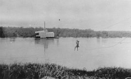
 Gold mining dredge on the Palmer River | |||||||||||||||
| Coordinates | 15°58′13″S 143°32′19″E / 15.9702°S 143.5386°E | ||||||||||||||
| Population | 46 (2021 census)[1] | ||||||||||||||
| • Density | 0.00599/km2 (0.01551/sq mi) | ||||||||||||||
| Postcode(s) | 4892 | ||||||||||||||
| Area | 7,682.4 km2 (2,966.2 sq mi) | ||||||||||||||
| Time zone | AEST (UTC+10:00) | ||||||||||||||
| LGA(s) | Shire of Cook | ||||||||||||||
| State electorate(s) | Cook | ||||||||||||||
| Federal division(s) | Leichhardt | ||||||||||||||
| |||||||||||||||
The former towns (now neighbourhoods) of Byerstown, Lukinville, Maytown, Palmerville and Stonyville (or Stony Creek), all dating from the 1870s-1880s gold rushes around the Palmer River, are within the locality.[3]
Geography
editThe Palmer River which flows through the locality from east to west. The Palmer River Goldfields Resource Reserve is the eastern part of the locality to the north of the river.
History
editKuku Yalanji (also known as Gugu Yalanji, Kuku Yalaja, and Kuku Yelandji) is an Australian Aboriginal language of the Mossman and Daintree areas of North Queensland. The language region includes areas within the local government area of Shire of Douglas and Shire of Cook, particularly the localities of Mossman, Daintree, Bloomfield River, China Camp, Maytown, Palmer, Cape Tribulation and Wujal Wujal.[4]
Yalanji (also known as Kuku Yalanji, Kuku Yalaja, Kuku Yelandji, and Gugu Yalanji) is an Australian Aboriginal language of Far North Queensland. The traditional language region is Mossman River in the south to the Annan River in the north, bordered by the Pacific Ocean in the east and extending inland to west of Mount Mulgrave. This includes the local government boundaries of the Shire of Douglas, the Shire of Cook and the Aboriginal Shire of Wujal Wujal and the towns and localities of Cooktown, Mossman, Daintree, Cape Tribulation and Wujal Wujal. It includes the head of the Palmer River, the Bloomfield River, China Camp, Maytown, and Palmerville.[5]
The locality takes its name from the Palmer River which flows through the locality from east to west and the Palmer goldfields around the river. The river was named on 5 August 1872 by William Hann after Arthur Hunter Palmer, then Premier of Queensland.[2]
Demographics
editIn the 2016 census, Palmer had "no people or a very low population".[6]
In the 2021 census, Palmer had a population of 46 people.[1]
Heritage listings
editPalmer has a number of heritage-listed sites, including:
- Conglomerate Range: Wild Irish Girl Mine and Battery[7]
- Laura to Maytown: Laura to Maytown Coach Road[8]
- Maytown Town Reserve: Maytown Township[9]
- Palmerville Station: Alexandra Mine and Battery[10]
- Stony Creek: Stonyville Township[11]
- Strathleven: Palmer River Gold Company Dredge[12]
Attractions
editThe Palmer River Goldfield Resource Reserve has old gold mines, rusting machinery, and some traces of the Maytown township for the visitor to explore.[13]
References
edit- ^ a b c Australian Bureau of Statistics (28 June 2022). "Palmer (SAL)". 2021 Census QuickStats. Retrieved 28 February 2023.
- ^ a b "Palmer – locality in Shire of Cook (entry 46137)". Queensland Place Names. Queensland Government. Retrieved 27 December 2020.
- ^ "Queensland place names search". Queensland Government. Retrieved 2 October 2022.
- ^ This Wikipedia article incorporates CC BY 4.0 licensed text from: "Kuku Yalanji". Queensland Aboriginal and Torres Strait Islander languages map. State Library of Queensland. Retrieved 28 January 2020.
- ^ This Wikipedia article incorporates CC BY 4.0 licensed text from: "Yalanji". Queensland Aboriginal and Torres Strait Islander languages map. State Library of Queensland. Retrieved 5 February 2020.
- ^ Australian Bureau of Statistics (27 June 2017). "Palmer (SSC)". 2016 Census QuickStats. Retrieved 20 October 2018.
- ^ "Wild Irish Girl Mine and Battery (entry 600428)". Queensland Heritage Register. Queensland Heritage Council. Retrieved 7 July 2013.
- ^ "Laura to Maytown Coach Road (entry 600427)". Queensland Heritage Register. Queensland Heritage Council. Retrieved 7 July 2013.
- ^ "Maytown Township (entry 602255)". Queensland Heritage Register. Queensland Heritage Council. Retrieved 7 July 2013.
- ^ "Alexandra Mine and Battery (entry 600429)". Queensland Heritage Register. Queensland Heritage Council. Retrieved 7 July 2013.
- ^ "Stonyville Township, Water Race and Cemetery (entry 600433)". Queensland Heritage Register. Queensland Heritage Council. Retrieved 7 July 2013.
- ^ "Palmer River Gold Company Dredge (entry 601871 )". Queensland Heritage Register. Queensland Heritage Council. Retrieved 7 July 2013.
- ^ "About Palmer Goldfield". Queensland Government. Archived from the original on 29 May 2014. Retrieved 31 May 2014.
External links
edit- "Palmer River". Queensland Places. Centre for the Government of Queensland, University of Queensland.
