This article needs additional citations for verification. (March 2022) |
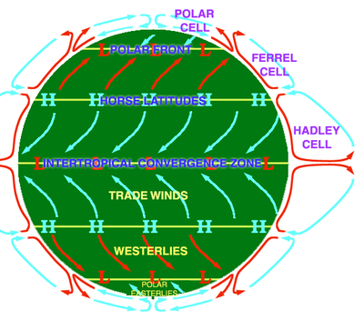
In meteorology, the polar front is the weather front boundary between the polar cell and the Ferrel cell around the 60° latitude, near the polar regions, in both hemispheres. At this boundary a sharp gradient in temperature occurs between these two air masses, each at very different temperatures.[1]

The polar front arises as a result of cold polar air meeting warm tropical air. It is a stationary front as the air masses are not moving against each other and stays stable.[2] Off the coast of eastern North America, especially in winter, there is a sharp temperature gradient between the snow-covered land and the warm offshore currents.
The polar front theory says that mid-latitude extratropical cyclones form on boundaries between warm and cold air.[3] In winter, the polar front shifts towards the Equator, whereas high pressure systems dominate more in the summer.
See also
editReferences
edit- ^ "Polar Front: What Is It & The Definition". Tomorrow.io Weather Blog. 2022-02-07. Retrieved 2022-05-22.
- ^ "What is a Polar Front?". www.kids-fun-science.com. Retrieved 2022-05-22.
- ^ "Temperate Cyclones (Mid Latitude Cyclone or Extra tropical cyclones or Frontal Cyclones)". PMF IAS. 2016-01-06. Retrieved 2022-05-22.