Palencia is a province of northern Spain, in the northern part of the autonomous community of Castile and León in the north of the Iberian Peninsula. It is bordered by the provinces of León, Cantabria, Burgos, and Valladolid.
Palencia | |
|---|---|
 Flag  Coat of arms | |
 Map of Spain with Palencia highlighted | |
| Coordinates: 42°25′N 4°30′W / 42.417°N 4.500°W | |
| Country | Spain |
| Autonomous community | |
| Capital | Palencia |
| Area | |
| • Total | 8,052 km2 (3,109 sq mi) |
| • Rank | Ranked 29th |
| 1.6% of Spain | |
| Population (2018)[1] | |
| • Total | 161,821 |
| • Rank | Ranked 46th |
| • Density | 20/km2 (52/sq mi) |
| Official language(s) | Spanish |
| Parliament | Cortes Generales |
| Website | Diputación de Palencia (in Spanish) |
Overview edit

Of the population of 176,125 (2002), 45% live in the capital, Palencia which is located on the Canal de Castilla. There are 191 municipalities in the province, of which more than half are villages with fewer than 200 people. The majority of the province is very sparsely-populated and has lost a significant proportion of its population since Francoist times due to rural to urban migration.
The major towns in the northern Montaña Palentina are: Guardo, a former coal mining town;[2] Aguilar de Campoo, a historic town famous for its biscuit production and Cervera de Pisuerga, a tourist town situated at the beginning of the Ruta de los Pantanos (the Reservoirs Route) and Barruelo de Santullán, which, as the centre of the province's coal mining industry, was the largest town in the province until the 1960s. Towns in the centre of the province include: Saldaña, known for the famous mosaics at the nearby Roman villa of La Olmeda, Herrera de Pisuerga, a village known for its summer activities and Crab Festival and Carrión de los Condes, a key monastery town on the Camino de Santiago. To the south of the city of Palencia are Venta de Baños, an important railway and industrial exchange, as well as Villamuriel de Cerrato, a village to that owes its development to the Renault factory[3] and its proximity to the capital.
During the Middle Ages, the Visigoths ruled Palencia. Basílica de San Juan, the oldest Visigothic church in Spain, was built in 661 in the province's Baños de Cerrato.[4] During the thirteenth century a university was founded in the province. It was the first university in Spain and one of the first in the world. It was later shifted to Valladolid.[5]
The province is bordered on the north by Cantabria, on the west by the province of León, on the east by the province of Burgos and on the south by the province of Valladolid. Two exclaves of the province, Cezura, and Lastrilla, are enclaves within Campoo, Cantabria, with the former being under 200 metres and the latter being just over 200 metres from the border at their closest point.
In Palencia large protected areas such as the Natural Park of Fuentes Carrionas and Fuente Cobre-Montaña Palencia are located.[6] The term historical region in Palencia, refers to those regions created in the fourteenth century, under the name merindades. Cantabrian Mountains are located in the northerns parts of the province. The 8,268 feet (2,520 metres) high Curavacas peak is located in the province.[7] The major commercial products produced in the province are barley, wheat, sugar beets, hemp, linen and woolen clothes, porcelain, leather, paper, and rugs. Food processing and metallurgy are major industries.[7] The province has three judicial districts–one each in Palencia, Carrión de los Condes and Cervera de Pisuerga.[8]
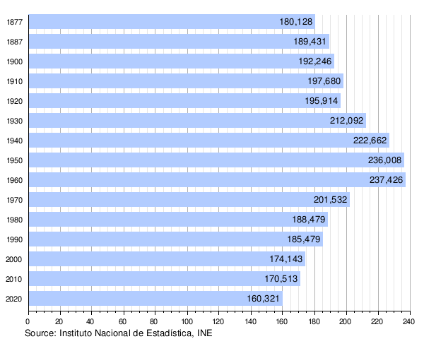
Population development edit
The historical population is given in the following chart:
See also edit
- List of municipalities in Palencia
- The Arauz Formation is situated in Palencia (Devonian of Spain).[9]
- El Golobar
References edit
- ^ Municipal Register of Spain 2018. National Statistics Institute.
- ^ Wagner, Robert Herman; García, L. G. Fernández; Eager, R. M. C. (1983). Geology and Palaeontology of the Guardo Coalfield (NE Leon - NW Palencia), Cantabrian Mts. IGME. p. 7. ISBN 978-84-7474-220-6.
- ^ Bank of London & South America (1976). Bank of London & South America Review. Vol. 10. Lloyds Bank International. p. 417.
- ^ Planet, Lonely (2012). Lonely Planet Valencia: Chapter from Spain Travel Guide. Lonely Planet Publications. p. 145. ISBN 978-1-74321-263-9.
- ^ Devine, Mary Elizabeth; Summerfield, Carol (2013), International Dictionary of University Histories, Taylor & Francis, p. 109, ISBN 978-1-134-26217-5
- ^ García, Carmelo Conesa; Guevara, Juan Bautista Martínez; Rogel, Yolanda Álvarez (2004), Medio ambiente, recursos y riesgos naturales: análisis mediante tecnologia SIG y teledetección, EDITUM, p. 84, ISBN 978-84-8371-485-0
- ^ a b "Palencia (Province, Spain)". Encyclopædia Britannica. Retrieved 30 September 2014.
- ^ "Judicial Districts" (in Spanish). Consejo General de Procuradores de España. Retrieved 30 September 2014.
- ^ Silur und Devon im Arauz-Gebiet (Prov. Palencia, N-Spanien). H. Jahnke, A. Henn, H. Mader and J. Schweineberg, 1983, Newsletters on Stratigraphy, 13(1), pages 40-66, doi:10.1127/nos/13/1983/40
External links edit
![]() Media related to Province of Palencia at Wikimedia Commons
Media related to Province of Palencia at Wikimedia Commons