Shiryōkaku (

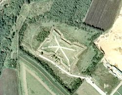
The fort covers an area of 21,500 m2, stretching approximately a hundred metres east to west and seventy metres north to south; the earthworks rise to a height of 3 m with a width of 5.4 m; they are surrounded by a dry moat 0.9 m deep and 2.7 m wide; the entrance is to the southwest.[2]
Shiryōkaku fell to government forces within a few hours on 11 May 1869.[3]
In 1934 the area was designated an Historic Site.[4] Repairs were carried out from 1970-2 and again in 1990.[3]
See also
editReferences
edit- ^ a b "
四 稜 郭 " [Shiryōkaku] (in Japanese). Hakodate City. Archived from the original on 19 December 2012. Retrieved 21 June 2012. - ^ "
四 稜 郭 " [Shiryōkaku] (in Japanese). Hokkaidō Prefecture. Archived from the original on 7 December 2012. Retrieved 21 June 2012. - ^ a b "
四 稜 郭 " [Shiryōkaku] (in Japanese). Hakodate City. Archived from the original on 5 June 2012. Retrieved 21 June 2012. - ^ "
四 稜 郭 " [Shiryōkaku] (in Japanese). Agency for Cultural Affairs. Retrieved 21 June 2012.