Tumxuk[2][3] is a county-level city in the western part of Xinjiang, China. The eastern part of Tumxuk is surrounded by Maralbexi County, Kashgar Prefecture. The smaller western part is near Kashgar.
Tumxuk
| |
|---|---|
.png) Location of Tumxuk City (red) jurisdiction in Xinjiang | |
 | |
 Tumxuk Location of the city centre in Xinjiang  Tumxuk Tumxuk (Xinjiang)  Tumxuk Tumxuk (China) | |
| Coordinates: 39°52′N 79°4′E / 39.867°N 79.067°E | |
| Country | China |
| Autonomous region | Xinjiang |
| Municipal seat | Jinxiu Subdistrict |
| Government | |
| • CCP Secretary | vacant (Political Commissar of the 3rd Division) |
| • Mayor | Xi Yan (Commander of the 3rd Division) |
| Area | |
| • Total | 1,927 km2 (744 sq mi) |
| Population (2020)[1] | |
| • Total | 263,245 |
| • Density | 140/km2 (350/sq mi) |
| Time zone | UTC+8 (China Standard[a]) |
| Website | www |
| Tumxuk | |||||||||||
|---|---|---|---|---|---|---|---|---|---|---|---|
| Chinese name | |||||||||||
| Simplified Chinese | 图木舒克 | ||||||||||
| Traditional Chinese | |||||||||||
| |||||||||||
| Uyghur name | |||||||||||
| Uyghur | تۇمشۇق | ||||||||||
| |||||||||||
Tumxuk is the headquarter of the 3rd Division of Xinjiang Production and Construction Corps and currently administered by the 3rd Division. The city implemented the "division and city integration" (师市
History
editIn 1997, Tumxuk City was established.[4]
Geography
editIt covers an area of 1,927 square kilometres (744 sq mi) and is located 1,222 kilometres (759 mi) southwest of Ürümqi.
Demographics
editAs of 2015, 101,042 (62.0%) of the 163,101 residents of the city were Uyghur, 60,914 (37.3%) were Han Chinese and 1,145 were from other ethnic groups.[5]
Transportation
editThe city is served by Tumushuke Tangwangcheng Airport and a branch from the Southern Xinjiang railway.
Administrative divisions
editTumxuk contains 3 subdistricts and 14 towns:
| Name | Simplified Chinese | Hanyu Pinyin | Uyghur (UEY) | Uyghur Latin (ULY) | Administrative division code | |
|---|---|---|---|---|---|---|
| Subdistricts | ||||||
| Jinxiu Subdistrict | 锦绣 |
Jǐnxiù Jiēdào | جىنشيۇ كوچا باشقارمىسى | Jinshyu kocha bashqarmisi | 659003001 | |
| Qianhai Subdistrict | Qiánhǎi Jiēdào | چيەنخاي كوچا باشقارمىسى | Chyenxay kocha bashqarmisi | 659003002 | ||
| Yong'anba Subdistrict | Yǒng'ānbà Jiēdào | يۇڭئەنبا كوچا باشقارمىسى | yung'enba kocha bashqarmisi | 659003003 | ||
| Towns | ||||||
| Caohu Town (41st Regiment Farm)* |
( |
Cǎohú Zhèn | ساۋخۇ بازىرى | Sawxu baziri | 659003100 | |
| Longkou Town (42nd Regiment Farm)* |
龙口镇 ( |
Lóngkǒu Zhèn | 659003101 | |||
| Qianhai Town (45th Regiment Farm)* |
( |
Qiánhǎi Zhèn | 659003102 | |||
| Yongxing Town (46th Regiment Farm)* |
( |
Yǒngxīng Zhèn | يۇڭشىڭ بازىرى | Yungshing baziri | 659003103 | |
| Xing'an Town (54th Regiment Farm)* |
兴安镇 ( |
Xīng'ān Zhèn | شىڭئەن بازىرى | shing'en baziri | 659003104 | |
| Jiahe Town (Payzawat Headquarters Farm of the 3rd Division)* |
( |
Jiāhé Zhèn | 659003105 | |||
| Hedong Town (48th Regiment Farm)* |
( |
Hédōng Zhèn | 659003106 | |||
| Xiahe Town (50th Regiment Farm)* |
( |
Xiàhé Zhèn | 659003107 | |||
| Yong'an Town (44th Regiment Farm)* |
( |
Yǒng'ān Zhèn | 659003108 | |||
| Hai'an Town (49th Regiment Farm)* |
( |
Hǎi'ān Zhèn | 659003109 | |||
| Tangyi Town (51st Regiment Farm)* |
( |
Tángyì Zhèn | 659003110 | |||
| Jinhuyang Town (53rd Regiment Farm)* |
( |
Jīnhúyáng Zhèn | 659003111 | |||
| Dongfeng Town (Dongfeng Farm of the 3rd Division)* |
东风镇 ( |
Dōngfēng Zhèn | 659003112 | |||
| Xinghua Town (Kargilik No. 2 Farm of the 3rd Division)* |
( |
Xìnghuā Zhèn | 659003113 | |||
Works of art
editTumxuk (usually spelled Tumshuq) is a well known archaeological site for Serindian art.
-
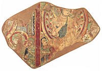 Tumshuk. Scenes of the Buddha preaching. 7th century CE
 -
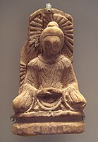 A Serindian art Buddha statue from Tumshuq, Xinjiang. 5th century.


See also
editFootnotes
edit- ^ Locals in Xinjiang frequently observe UTC+6 (Xinjiang Time), 2 hours behind Beijing.
- ^ Xinjiang: Prefectures, Cities, Districts and Counties
- ^ The official spelling according to Zhōngguó dìmínglù,
中国 地名 录 (Beijing, SinoMaps Press中国 地 图出版 社 1997); ISBN 7-5031-1718-4 - ^ The official spelling is "Tumxuk" according to Zhōngguó dìmínglù,
中国 地名 录 (Beijing, SinoMaps Press中国 地 图出版 社 1997); ISBN 7-5031-1718-4; p. 312. - ^ 图木舒克
市 历史沿革 [Tumxuk City Historical Evolution]. XZQH.org. 18 April 2015. Retrieved 8 April 2020.1997
年 中央 为进一步加强新疆生产建设兵团工作,下 发中发[1997]17号 文 件 ,批准 在 农三师图木休克垦区(即 小海 子 灌区)设立图木舒克市 ,为自治 区 直 辖县级市。 - ^ 3-7
各地 、州 、市 、县(市 )分 民族 人口 数 (in Simplified Chinese). شىنجاڭ ئۇيغۇر ئاپتونوم رايونى,新 疆维吾 尔自治 区 统计局 Statistic Bureau of Xinjiang Uygur Autonomous Region. Archived from the original on 2017-10-11. Retrieved 2017-09-03.
External links
edit- Tumxuk Government website (in Chinese)