
Dambel: Difference between revisions
No edit summary |
No edit summary |
||
| (5 intermediate revisions by 4 users not shown) | |||
| Line 39: | Line 39: | ||
| footnotes = |
| footnotes = |
||
}} |
}} |
||
[[File:Dambel.jpg|thumb|the town of Dambel]] |
[[File:Dambel.jpg|thumb|left|300px|the town of Dambel]] |
||
'''Dambel''' ( |
'''Dambel''' ([[Nones language|Nones]]: ''Dambel''; {{lang-la|Ambulum}}) is a ''[[Communes of Trentino|comune]]'' (municipality) in [[Trentino]] in the northern [[Italy|Italian]] region [[Trentino-Alto Adige/Südtirol]], located about {{convert|35|km|mi}} north of the city of [[Trento]]. |
||
Dambel is located in the [[Val di Non]] at an elevation of {{convert|750|m|ft}}. It is on the provincial highway between [[Sanzeno]] to the south and [[Sarnonico]] to the north. The town's name derives from the Latin word ''ambulum'' because it was at an historical crossroads on the commercial road between [[Lombardy]] and [[Germany]], which crossed through Dambel and over the Novella River at the Pozzena bridge. Today the economy of Dambel is concentrated on the production of apples. |
Dambel is located in the [[Val di Non]] at an elevation of {{convert|750|m|ft}}. It is on the provincial highway between [[Sanzeno]] to the south and [[Sarnonico]] to the north. The town's name derives from the Latin word ''ambulum'' because it was at an historical crossroads on the commercial road between [[Lombardy]] and [[Germany]], which crossed through Dambel and over the Novella River at the Pozzena bridge. Today the economy of Dambel is concentrated on the production of apples. |
||
| Line 47: | Line 47: | ||
As of 31 December 2004, it had a population of 436 and an area of {{convert|5.1|km2|mi2}}.<ref name="istat">All demographics and other statistics: Italian statistical institute [[National Institute of Statistics (Italy)|Istat]].</ref> |
As of 31 December 2004, it had a population of 436 and an area of {{convert|5.1|km2|mi2}}.<ref name="istat">All demographics and other statistics: Italian statistical institute [[National Institute of Statistics (Italy)|Istat]].</ref> |
||
Dambel borders the following municipalities: [[Brez]], [[Sarnonico]], [[Cloz]], [[Romallo]], [[Romeno]] and [[Sanzeno]]. |
Dambel borders the following municipalities: [[Brez, Trentino|Brez]], [[Sarnonico]], [[Cloz]], [[Romallo]], [[Romeno]] and [[Sanzeno]]. |
||
==Demographic evolution== |
==Demographic evolution== |
||
| Line 120: | Line 120: | ||
bar:2001 at:424 fontsize:XS text: 424 shift:(-8,5) |
bar:2001 at:424 fontsize:XS text: 424 shift:(-8,5) |
||
bar:2004 at:436 fontsize:XS text: 436 shift:(-8.5) |
bar:2004 at:436 fontsize:XS text: 436 shift:(-8.5) |
||
TextData= |
TextData= |
||
| Line 132: | Line 131: | ||
==External links== |
==External links== |
||
*{{ |
*{{in lang|it}} [https://web.archive.org/web/20080827223914/http://www.comunedambel.it/ Homepage of the city] |
||
{{clear}} |
{{clear}} |
||
{{Trentino}} |
{{Trentino}} |
||
{{authority control}} |
|||
[[Category:Cities and towns in Trentino-Alto Adige/Südtirol]] |
[[Category:Cities and towns in Trentino-Alto Adige/Südtirol]] |
||
Latest revision as of 01:07, 15 October 2021
Dambel | |
|---|---|
| Comune di Dambel | |
Location of Dambel  | |
 Dambel Location of Dambel in Italy  Dambel Dambel (Trentino-Alto Adige/Südtirol) | |
| Coordinates: 46°24′N 11°6′E / 46.400°N 11.100°E | |
| Country | Italy |
| Region | Trentino-Alto Adige/Südtirol |
| Province | Trentino (TN) |
| Government | |
| • Mayor | Carlo Polastri |
| Area | |
| • Total | 5.1 km2 (2.0 sq mi) |
| Elevation | 750 m (2,460 ft) |
| Population (Dec. 2004)[2] | |
| • Total | 436 |
| • Density | 85/km2 (220/sq mi) |
| Demonym | Dambellesi |
| Time zone | UTC+1 (CET) |
| • Summer (DST) | UTC+2 (CEST) |
| Postal code | 38010 |
| Dialing code | 0463 |
| Patron saint | Santa Maria Assunta |
| Saint day | August 15 |
| Website | Official website |

Dambel (Nones: Dambel; Latin: Ambulum) is a comune (municipality) in Trentino in the northern Italian region Trentino-Alto Adige/Südtirol, located about 35 kilometres (22 mi) north of the city of Trento.
Dambel is located in the Val di Non at an elevation of 750 metres (2,460 ft). It is on the provincial highway between Sanzeno to the south and Sarnonico to the north. The town's name derives from the Latin word ambulum because it was at an historical crossroads on the commercial road between Lombardy and Germany, which crossed through Dambel and over the Novella River at the Pozzena bridge. Today the economy of Dambel is concentrated on the production of apples.
Geography[edit]
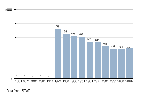
As of 31 December 2004, it had a population of 436 and an area of 5.1 square kilometres (2.0 sq mi).[3]
Dambel borders the following municipalities: Brez, Sarnonico, Cloz, Romallo, Romeno and Sanzeno.
Demographic evolution[edit]
References[edit]
- ^ "Superficie di Comuni Province e Regioni italiane al 9 ottobre 2011". Italian National Institute of Statistics. Retrieved 16 March 2019.
- ^ "Popolazione Residente al 1° Gennaio 2018". Italian National Institute of Statistics. Retrieved 16 March 2019.
- ^ All demographics and other statistics: Italian statistical institute Istat.
External links[edit]
- (in Italian) Homepage of the city

This Trentino-Alto Adige/Südtirol location article is a stub. You can help Wikipedia by expanding it. |