A4 road (Latvia): Difference between revisions
Appearance
Content deleted Content added
m plural |
Rescuing 0 sources and tagging 1 as dead.) #IABot (v2.0.9.5 |
||
| (29 intermediate revisions by 19 users not shown) | |||
| Line 1: | Line 1: | ||
{{Short description|Road in Latvia}} |
|||
{{other uses|A4 road}} |
{{other uses|A4 road}} |
||
{{Infobox road |
{{Infobox road |
||
| Line 4: | Line 6: | ||
|type = A |
|type = A |
||
|route = 4 |
|route = 4 |
||
|alternate_name = {{lang|lv| |
|alternate_name = {{lang|lv|Rīgas apvedceļš}} |
||
|map = |
|map = Road A4 Latvia.svg |
||
|e-road={{ |
|e-road={{Jct|country=LVA|E|22}}{{Jct|country=LVA|E|67}}{{Jct|country=LVA|E|77}} |
||
|length_km=20.5 |
|length_km=20.5 |
||
|terminus_a=[[Baltezers]] |
|terminus_a=[[Baltezers, Ādaži Municipality|Baltezers]] |
||
|junction= |
|junction= |
||
|terminus_b=[[Saulkalne]] |
|terminus_b=[[Saulkalne]] |
||
| Line 17: | Line 19: | ||
}} |
}} |
||
The '''A4''' is a [[List of National Roads in Latvia|national road in Latvia]] |
The '''A4''' (Also known as the Riga Bypass) is a [[List of National Roads in Latvia|national road in Latvia]] and part of the [[Riga]] [[ring road]], connecting [[Baltezers, Ādaži Municipality|Baltezers]] to [[Saulkalne]].<ref>{{cite web |url=http://www.lvceli.lv/lv/?i=18 |title=Latvijas Valsts ceļi -> Valsts galvenie autoceļi (A) |website=www.lvceli.lv |access-date=22 May 2022 |archive-url=https://web.archive.org/web/20050125063351/http://www.lvceli.lv/lv/?i=18 |archive-date=25 January 2005 |url-status=dead}}</ref> |
||
The road is part of [[European route E67]], [[European route E77]] and Latvian [[TEN-T]] road network. |
|||
It has one lane in each direction spanning the entire length. |
|||
It was reported that around 2020 widening of the road to 2x2 lanes will commence. As result it would receive an expressway or motorway status, and the current 90 km/h speed limit would be raised.<ref name=":0">http://www.lvceli.lv/LV/?i=766e{{dead link|date=September 2016 |bot=InternetArchiveBot |fix-attempted=yes }}</ref> The [[AADT|Annual average daily traffic]] of the A4 in 2016 was 11,954 cars per day. |
|||
== History == |
|||
Construction on the A4 started in 1964 and was completed in 1980. |
|||
In 2011/2012 part of the A4 was rebuilt,<ref>{{Cite web |url=http://www.lvceli.lv/LV/PC/PageImages/Original/1473.jpg |title = 1473.JPG (4272x2559 pixels) |archive-url=https://archive.today/20120906094313/http://www.lvceli.lv/LV/PC/PageImages/Original/1473.jpg |archive-date=6 September 2012 |url-status=dead}}</ref> |
|||
== Crossings == |
== Crossings == |
||
{{RJL|date=November 2021}} |
|||
<center> |
|||
{| class="wikitable" |
{| class="wikitable" style="margin:1em auto;" |
||
! # !! Road name !! Location |
! # !! Road name !! Location |
||
|---- |
|---- |
||
| Line 33: | Line 47: | ||
| 4 || [[A6 road (Latvia)|A6]] || [[Saulkalne]] |
| 4 || [[A6 road (Latvia)|A6]] || [[Saulkalne]] |
||
|} |
|} |
||
</center> |
|||
== Major cities crossed== |
== Major cities crossed== |
||
| Line 49: | Line 62: | ||
==External links== |
==External links== |
||
*[http://g.co/maps/9pq42 Autoceļš A4 in Google Maps] |
*[http://g.co/maps/9pq42 Autoceļš A4 in Google Maps]{{Dead link|date=July 2023 |bot=InternetArchiveBot |fix-attempted=yes }} |
||
{{Coord|56.931516|N|24.388142|E|display=title}} |
{{Coord|56.931516|N|24.388142|E|display=title}} |
||
| Line 59: | Line 72: | ||
{{Latvia-geo-stub}} |
{{Latvia-geo-stub}} |
||
{{Latvia-transport-stub}} |
{{Latvia-transport-stub}} |
||
[[de:Autoceļš A4]] |
|||
[[lv:Autoceļš A4 (Latvija)]] |
|||
[[lt:Magistralinis kelias A4 (Latvija)]] |
|||
[[nl:A4 (Letland)]] |
|||
Latest revision as of 07:18, 25 July 2023
| A4 | ||||
|---|---|---|---|---|
| Rīgas apvedceļš | ||||
 | ||||
| Route information | ||||
| Part of | ||||
| Length | 20.5 km (12.7 mi) | |||
| Major junctions | ||||
| From | Baltezers | |||
| To | Saulkalne | |||
| Location | ||||
| Country | Latvia | |||
| Highway system | ||||
| ||||
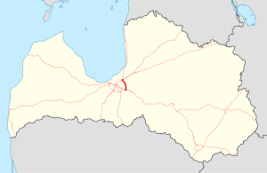
The A4 (Also known as the Riga Bypass) is a national road in Latvia and part of the Riga ring road, connecting Baltezers to Saulkalne.[1]
The road is part of European route E67, European route E77 and Latvian TEN-T road network.
It has one lane in each direction spanning the entire length.
It was reported that around 2020 widening of the road to 2x2 lanes will commence. As result it would receive an expressway or motorway status, and the current 90 km/h speed limit would be raised.[2] The Annual average daily traffic of the A4 in 2016 was 11,954 cars per day.
History
[edit]Construction on the A4 started in 1964 and was completed in 1980.
In 2011/2012 part of the A4 was rebuilt,[3]
Crossings
[edit]This article contains a bulleted list or table of intersections which should be presented in a properly formatted junction table. (November 2021) |
| # | Road name | Location |
|---|---|---|
| 1 | P1 | Upesciems |
| 2 | P4 | Ūlupji |
| 3 | P11 | Saurieši |
| 4 | A6 | Saulkalne |
Major cities crossed
[edit]Gallery
[edit]-
A4 in 2007.
References
[edit]- ^ "Latvijas Valsts ceļi -> Valsts galvenie autoceļi (A)". www.lvceli.lv. Archived from the original on 25 January 2005. Retrieved 22 May 2022.
- ^ http://www.lvceli.lv/LV/?i=766e[permanent dead link]
- ^ "1473.JPG (4272x2559 pixels)". Archived from the original on 6 September 2012.
External links
[edit]56°55′53″N 24°23′17″E / 56.931516°N 24.388142°E


