Como, Colorado: Difference between revisions
Magnolia677 (talk | contribs) |
|||
| (14 intermediate revisions by 13 users not shown) | |||
| Line 1: | Line 1: | ||
{{short description|Unincorporated community in Park County, Colorado, United States}} |
|||
{{refimprove|date=February 2011}} |
|||
{{Use mdy dates|date=July 2023}} |
|||
{{Infobox settlement |
{{Infobox settlement |
||
<!-- Basic info ----------------> |
<!-- Basic info ----------------> |
||
| Line 10: | Line 11: | ||
|image_skyline = Como Roundhouse.JPG |
|image_skyline = Como Roundhouse.JPG |
||
|imagesize = 225px |
|imagesize = 225px |
||
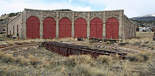
|image_caption = Como Roundhouse is the only narrow-gauge [[roundhouse]] still standing in Colorado. Until 1937, it handled repairs on the railroads. In 1938, the remaining tracks were removed. |
|image_caption = Como Roundhouse is the only narrow-gauge [[Railway roundhouse|roundhouse]] still standing in Colorado. Until 1937, it handled repairs on the railroads. In 1938, the remaining tracks were removed. |
||
|image_flag = |
|image_flag = |
||
|flag_size = |
|flag_size = |
||
| Line 31: | Line 32: | ||
|pushpin_mapsize = |
|pushpin_mapsize = |
||
<!-- Location ------------------> |
<!-- Location ------------------> |
||
|subdivision_type = [[List of |
|subdivision_type = [[List of sovereign states|Country]] |
||
|subdivision_name = {{USA}} |
|subdivision_name = {{USA}} |
||
|subdivision_type1 = [[ |
|subdivision_type1 = [[U.S. state|State]] |
||
|subdivision_name1 = {{flag|Colorado|name=State of Colorado}} |
|subdivision_name1 = {{flag|Colorado|name=State of Colorado}} |
||
|subdivision_type2 = [[List of counties in Colorado|County]] |
|subdivision_type2 = [[List of counties in Colorado|County]] |
||
| Line 39: | Line 40: | ||
|subdivision_type3 = |
|subdivision_type3 = |
||
|subdivision_name3 = |
|subdivision_name3 = |
||
|subdivision_type4 = |
|||
|subdivision_name4 = |
|||
<!-- Politics -----------------> |
<!-- Politics -----------------> |
||
|government_footnotes = |
|government_footnotes = |
||
| Line 50: | Line 49: | ||
|leader_title2 = |
|leader_title2 = |
||
|leader_name2 = |
|leader_name2 = |
||
|leader_title3 = |
|||
| ⚫ | |||
|leader_title4 = |
|||
|leader_name4 = |
|||
|established_title = <!-- Settled --> |
|established_title = <!-- Settled --> |
||
|established_date = |
|established_date = |
||
|established_title2 = <!-- Incorporated (town) --> |
|established_title2 = <!-- Incorporated (town) --> |
||
|established_date2 = |
|established_date2 = |
||
|established_title3 = <!-- Incorporated (city) --> |
|||
|established_date3 = |
|||
<!-- Area ---------------------> |
<!-- Area ---------------------> |
||
|area_magnitude = |
|area_magnitude = |
||
| Line 65: | Line 58: | ||
|area_footnotes = |
|area_footnotes = |
||
|area_total_km2 = <!-- ALL fields dealing with a measurements are subject to automatic unit conversion--> |
|area_total_km2 = <!-- ALL fields dealing with a measurements are subject to automatic unit conversion--> |
||
|area_land_km2 = <!--See table @ Template:Infobox Settlement for details on automatic unit conversion--> |
|||
|area_water_km2 = |
|||
|area_total_sq_mi = |
|||
|area_land_sq_mi = |
|||
|area_water_sq_mi = |
|||
|area_water_percent = |
|||
|area_urban_km2 = |
|||
|area_urban_sq_mi = |
|||
|area_metro_km2 = |
|||
|area_metro_sq_mi = |
|||
|area_blank1_title = |
|||
|area_blank1_km2 = |
|||
|area_blank1_sq_mi = |
|||
<!-- Population -----------------------> |
<!-- Population -----------------------> |
||
|population_as_of = |
|population_as_of = 2010 |
||
|population_footnotes = |
|population_footnotes = |
||
|population_note = |
|population_note = |
||
|population_total = |
|population_total = 439 |
||
|population_density_km2 = |
|||
|population_density_sq_mi = |
|||
|population_metro = |
|||
|population_density_metro_km2 = |
|||
|population_density_metro_sq_mi = |
|||
|population_urban = |
|||
|population_density_urban_km2 = |
|||
|population_density_urban_sq_mi = |
|||
|population_blank1_title = |
|||
|population_blank1 = |
|||
|population_density_blank1_km2 = |
|||
|population_density_blank1_sq_mi = |
|||
<!-- General information ---------------> |
<!-- General information ---------------> |
||
|timezone = [[Mountain Standard Time|MST]] |
|timezone = [[Mountain Standard Time|MST]] |
||
| Line 100: | Line 68: | ||
|timezone_DST = [[Mountain Daylight Time|MDT]] |
|timezone_DST = [[Mountain Daylight Time|MDT]] |
||
|utc_offset_DST = -6 |
|utc_offset_DST = -6 |
||
|coordinates = {{coord|39|18| |
|coordinates = {{coord|39|18|58|N|105|53|34|W|region:US_type:city|display=inline,title}} |
||
|elevation_footnotes = <ref name= |
|elevation_footnotes = <ref name=gnis/> |
||
| ⚫ | |||
|elevation_m = 2991 |
|||
|elevation_ft = |
|||
<!-- Area/postal codes & others --------> |
<!-- Area/postal codes & others --------> |
||
|postal_code_type = [[ZIP Code]]<ref name=ZIPcode>{{cite web|date=December 22, 2006 |url=http://zip4.usps.com/zip4/citytown.jsp |title=ZIP Code Lookup |format=[[JavaScript]]/[[HTML]] |publisher=United States Postal Service |accessdate=December 22, 2006 | |
|postal_code_type = [[ZIP Code]]<ref name=ZIPcode>{{cite web|date=December 22, 2006 |url=http://zip4.usps.com/zip4/citytown.jsp |title=ZIP Code Lookup |format=[[JavaScript]]/[[HTML]] |publisher=United States Postal Service |accessdate=December 22, 2006 |url-status=dead |archiveurl=https://web.archive.org/web/20070903025217/http://zip4.usps.com/zip4/citytown.jsp |archivedate=September 3, 2007 }}</ref> |
||
|postal_code = 80432 |
|postal_code = 80432 |
||
|area_code = |
|area_code = |
||
|blank_name = |
|blank_name = [[Geographic Names Information System|GNIS]] feature ID |
||
|blank_info = |
|blank_info = 183395<ref name=gnis>{{GNIS|183395}}</ref> |
||
|blank1_name = |
|||
|blank1_info = |
|||
|website = |
|website = |
||
|footnotes = |
|footnotes = |
||
}} |
}} |
||
| ⚫ | |||
| ⚫ | |||
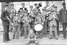
[[File:Como band.jpg|thumb|right|Band in Como, c. 1900]] |
|||
'''Como''' is an [[Unincorporated area|unincorporated community]] in [[Park County, Colorado|Park County]] in the [[Rocky Mountains]] of central [[Colorado]], |
'''Como''' is an [[Unincorporated area|unincorporated community]] in [[Park County, Colorado|Park County]] in the [[Rocky Mountains]] of central [[Colorado]], United States. According to the [[2010 United States Census|2010 census]], the population of zip code 80432 is 439, including surrounding subdivisions in a 15 mile radius. Metropolitan Como proper usually has a population of 12 to 15 residents, within the Como plat.<ref>{{cite web|url=https://www.zip-codes.com/zip-code/80432/zip-code-80432-2010-census.asp|title=2010 Census Population for ZIP Code 80432|publisher=zip-coedes.com|accessdate=February 4, 2014}}</ref> |
||
==History== |
==History== |
||
| ⚫ | |||
It is believed the town was named by miners from [[Como]], [[Italy]], who worked the coal fields of the area. In 1879, the town became the location of a [[Train station|depot]] of the [[Denver, South Park and Pacific Railroad]], which was extended over [[Kenosha Pass]] to reach the [[silver]] mining areas during the [[Colorado Silver Boom]]. Later, the town served as a division point for trains going northward over Boreas Pass and southward toward Garos and over [[Trout Creek Pass]] at the western end of South Park |
It is believed the town was named by miners from [[Como]], [[Italy]], who worked the coal fields of the area. In 1879, the town became the location of a [[Train station|depot]] of the [[Denver, South Park and Pacific Railroad]], which was extended over [[Kenosha Pass]] to reach the [[silver]] mining areas during the [[Colorado Silver Boom]]. Later, the town served as a division point for trains going northward over Boreas Pass and southward toward Garos and over [[Trout Creek Pass]] at the western end of South Park. |
||
==Current status== |
|||
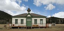
With a population in the [[1910 United States Census|1910 census]] of 475, 36 more than in 2010, Como was then the largest community in Park County. There were eighty-three children of school age that year. The former Como High School had begun in an abandoned [[Presbyterianism|Presbyterian Church]], which was moved to another site. The school closed in either 1940 or 1941, by which time railroad service to Como had already ended some three years earlier. The remaining pupils were bused to Fairplay. The old Como High School building was left intact and used for the storage of decades of school records and memorabilia, items which were rediscovered in the 1990s. The former school, with a well-preserved classroom, is open to the public only once annually, on Boreas Pass Railroad Day, but students may visit on field trips. The school provides a glimpse into yesteryear.<ref>Laura King Van Dusen, "Como High School: An Unplanned Time Capsule of Earlier Days, Artifacts Uncovered from Como's Heyday," ''Historic Tales from Park County: Parked in the Past'' ([[Charleston, South Carolina|Charleston]], [[South Carolina]]: The History Press, 2013), {{ISBN|978-1-62619-161-7}}, pp. 163-169.</ref> |
|||
The town has many historic weathered structures, including the roundhouse, hotel, and depot. It has the air of a [[ghost town]] that is still nevertheless populated. Como has a small commercial district consisting of a post office, gallery and hotel. The roundhouse and depot have been renovated by the [[Denver, South Park & Pacific Historical Society]] with plans to make them into an [[Como Roundhouse, Railroad Depot and Hotel Complex|area tourist attraction]].<ref>Laura King Van Dusen, "Como High School: An Unplanned Time Capsule of Earlier Days, Artifacts Uncovered from Como's Heyday," ''Historic Tales from Park County: Parked in the Past'' ([[Charleston, South Carolina|Charleston]], [[South Carolina]]: The History Press, 2013), {{ISBN|978-1-62619-161-7}}, pp. 163-169.</ref>{{clear left}} |
|||
[[File:Downtown Como, Colorado, With The Como Hotel In The Background.jpg|thumb|A view of the dilapidated downtown of Como in August 2022]] |
|||
==Geography== |
==Geography== |
||
| ⚫ | |||
Como is located at the northern end of [[South Park (Park County, Colorado)|South Park]], Como is an historic railroad settlement. It sits approximately one-half mile (1 km) west of [[U.S. Route 285]] and some nine miles (15 km) northeast of the [[county seat]] of [[Fairplay, Colorado|Fairplay]]. Como is accessible by a paved County Road 33, which becomes gravel inside the town. Boreas Pass Road runs northwest over [[Boreas Pass]] to [[Breckenridge, Colorado|Breckenridge]]. The mountains northwest of Como form a dramatic background to the site of the town on the flank of [[Little Baldy Mountain]]. |
Como is located at the northern end of [[South Park (Park County, Colorado)|South Park]], Como is an historic railroad settlement. It sits approximately one-half mile (1 km) west of [[U.S. Route 285]] and some nine miles (15 km) northeast of the [[county seat]] of [[Fairplay, Colorado|Fairplay]]. Como is accessible by a paved County Road 33, which becomes gravel inside the town. Boreas Pass Road runs northwest over [[Boreas Pass]] to [[Breckenridge, Colorado|Breckenridge]]. The mountains northwest of Como form a dramatic background to the site of the town on the flank of [[Little Baldy Mountain]]. |
||
==Notable people== |
|||
On May 13, 2011, Marshal Adolph E. Cook of Como was inducted into the [[National Law Enforcement Memorial]] in [[Washington, D.C.]] Earlier in 1999, he was inducted into the Colorado Law Enforcement Memorial. He is the only law enforcement officer from Park County to qualify for in his case [[Posthumous recognition|posthumous]] honors. Cook was shot to death in 1894 when he came to a Como residence to break up a loud party. Two women at the party, including [[Anna Blythe Speas]], were charged with [[Accessory (legal term)|accessory]] to [[murder]] but acquitted. Speas' tragic life story is told in the book ''Historic Tales from Park County: Parked in the Past'' by the journalist Laura King Van Dusen, who writes for the newspaper ''The Flume'' in Fairplay.<ref>Laura King Van Dusen, "The Short, Tragic Life of Anna Blythe Speas: Belle of Boulder, Suspected Criminal in Como, Dead in Denver at Twenty-eight", ''Historic Tales from Park County: Parked in the Past'', pp. 113-125.</ref> |
|||
==See also== |
==See also== |
||
{{stack|{{portal|Colorado}}}} |
|||
* [[Denver-Aurora Metropolitan Statistical Area]] |
|||
* [[Denver-Aurora-Boulder Combined Statistical Area]] |
|||
| ⚫ | |||
* [[List of cities and towns in Colorado]] |
* [[List of cities and towns in Colorado]] |
||
| ⚫ | |||
==References== |
==References== |
||
{{ |
{{reflist|22em}} |
||
==External links== |
|||
{{commons category-inline|Como, Colorado}} |
|||
{{Park County, Colorado}} |
{{Park County, Colorado}} |
||
{{authority control}} |
|||
[[Category:Unincorporated communities in Park County, Colorado]] |
[[Category:Unincorporated communities in Park County, Colorado]] |
||
Latest revision as of 20:09, 16 October 2023
Como, Colorado | |
|---|---|
 Como Roundhouse is the only narrow-gauge roundhouse still standing in Colorado. Until 1937, it handled repairs on the railroads. In 1938, the remaining tracks were removed. | |
| Coordinates: 39°18′58″N 105°53′34″W / 39.31611°N 105.89278°W | |
| Country | |
| State | |
| County | Park County[1] |
| Elevation | 9,813 ft (2,991 m) |
| Population (2010) | |
| • Total | 439 |
| Time zone | UTC-7 (MST) |
| • Summer (DST) | UTC-6 (MDT) |
| ZIP Code[3] | 80432 |
| GNIS feature ID | 183395[2] |
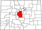
Como is an unincorporated community in Park County in the Rocky Mountains of central Colorado, United States. According to the 2010 census, the population of zip code 80432 is 439, including surrounding subdivisions in a 15 mile radius. Metropolitan Como proper usually has a population of 12 to 15 residents, within the Como plat.[4]
History
[edit]
It is believed the town was named by miners from Como, Italy, who worked the coal fields of the area. In 1879, the town became the location of a depot of the Denver, South Park and Pacific Railroad, which was extended over Kenosha Pass to reach the silver mining areas during the Colorado Silver Boom. Later, the town served as a division point for trains going northward over Boreas Pass and southward toward Garos and over Trout Creek Pass at the western end of South Park.
Current status
[edit]The town has many historic weathered structures, including the roundhouse, hotel, and depot. It has the air of a ghost town that is still nevertheless populated. Como has a small commercial district consisting of a post office, gallery and hotel. The roundhouse and depot have been renovated by the Denver, South Park & Pacific Historical Society with plans to make them into an area tourist attraction.[5]

Geography
[edit]

Como is located at the northern end of South Park, Como is an historic railroad settlement. It sits approximately one-half mile (1 km) west of U.S. Route 285 and some nine miles (15 km) northeast of the county seat of Fairplay. Como is accessible by a paved County Road 33, which becomes gravel inside the town. Boreas Pass Road runs northwest over Boreas Pass to Breckenridge. The mountains northwest of Como form a dramatic background to the site of the town on the flank of Little Baldy Mountain.
See also
[edit]References
[edit]- ^ "US Board on Geographic Names". United States Geological Survey. October 25, 2007. Retrieved January 31, 2008.
- ^ a b U.S. Geological Survey Geographic Names Information System: Como, Colorado
- ^ "ZIP Code Lookup". United States Postal Service. December 22, 2006. Archived from the original (JavaScript/HTML) on September 3, 2007. Retrieved December 22, 2006.
- ^ "2010 Census Population for ZIP Code 80432". zip-coedes.com. Retrieved February 4, 2014.
- ^ Laura King Van Dusen, "Como High School: An Unplanned Time Capsule of Earlier Days, Artifacts Uncovered from Como's Heyday," Historic Tales from Park County: Parked in the Past (Charleston, South Carolina: The History Press, 2013), ISBN 978-1-62619-161-7, pp. 163-169.
External links
[edit]![]() Media related to Como, Colorado at Wikimedia Commons
Media related to Como, Colorado at Wikimedia Commons


