
Pemba Island: Difference between revisions
Narky Blert (talk | contribs) Link to DAB page repaired |
m Fixed typos (via WP:JWB) |
||
| (29 intermediate revisions by 23 users not shown) | |||
| Line 1: | Line 1: | ||
{{ |
{{Short description|Tanzanian island of the Zanzibar Archipelago}} |
||
{{Infobox islands |
{{Infobox islands |
||
|name=Pemba |
|name=Pemba |
||
|image_name=File:Vumawimbi Beach, Pemba Island.jpg |
|image_name=File:Vumawimbi Beach, Pemba Island.jpg |
||
|image_caption=Vumawimbi Beach, Pemba Island |
|image_caption=Vumawimbi Beach, Pemba Island |
||
|sobriquet={{small|{{lang|ar|الجزيرة الخضراء}}<br />''Al Jazeera al |
|sobriquet={{small|{{lang|ar|الجزيرة الخضراء}}<br />''Al Jazeera al Khizra'' (the green island)}}{{Citation needed|date=July 2022}} |
||
|pushpin_map=Tanzania#Africa |
|pushpin_map=Tanzania#Africa |
||
|pushpin_map_caption=Location in Tanzania |
|pushpin_map_caption=Location in Tanzania |
||
| Line 28: | Line 28: | ||
|website={{URL|http://www.tanzania.go.tz/|Country website}} |
|website={{URL|http://www.tanzania.go.tz/|Country website}} |
||
}} |
}} |
||
'''Pemba Island''' ({{lang-ar|الجزيرة الخضراء}} ''al-Jazīra al- |
'''Pemba Island''' ({{lang-ar|الجزيرة الخضراء}} ''al-Jazīra al-khadrāʔ'', literally "The Green Island"{{Citation needed|date=July 2022}}; {{lang-sw|Pemba kisiwa}}) is a [[Tanzania|Tanzanian]] island forming part of the [[Zanzibar Archipelago]], lying within the [[Swahili Coast]] in the [[Indian Ocean]]. |
||
==Geography== |
==Geography== |
||
[[file:Map of Zanzibar Archipelago-en.svg|thumb|left|The main islands of the [[Zanzibar Archipelago]]: Unguja (left) and Pemba (right)]] |
[[file:Map of Zanzibar Archipelago-en.svg|thumb|left|The main islands of the [[Zanzibar Archipelago]]: Unguja (left) and Pemba (right)]] |
||
With a land area of {{convert|988|km²}}<ref>[http://www.nbs.go.tz/takwimu/references/Tanzania_in_figures2012.pdf Tanzania in figures 2012, National Bureau of Statistics, Ministry of Finance, June 2013, page 7] {{webarchive|url=https://web.archive.org/web/20131126120431/http://www.nbs.go.tz/takwimu/references/Tanzania_in_figures2012.pdf |date=2013-11-26 }}</ref> it is situated about {{convert|50|km|mi}} to the north of [[Unguja]], the largest island of the archipelago. In 1964, [[Zanzibar]] was united with the former colony of [[Tanganyika]] to form [[Tanzania]]. It lies {{convert|50|km|mi}} east of mainland Tanzania, across the [[Pemba Channel]]. Together with [[Mafia Island]] (south of Unguja), these islands form the Spice Islands (not to be confused with the [[Maluku Islands]] of [[Indonesia]]). |
With a land area of {{convert|988|km²}}<ref>[http://www.nbs.go.tz/takwimu/references/Tanzania_in_figures2012.pdf Tanzania in figures 2012, National Bureau of Statistics, Ministry of Finance, June 2013, page 7] {{webarchive|url=https://web.archive.org/web/20131126120431/http://www.nbs.go.tz/takwimu/references/Tanzania_in_figures2012.pdf |date=2013-11-26 }}</ref> it is situated about {{convert|50|km|mi}} to the north of [[Unguja]], the largest island of the archipelago. In 1964, [[Zanzibar]] was united with the former colony of [[Tanganyika (1961–1964)|Tanganyika]] to form [[Tanzania]]. It lies {{convert|50|km|mi}} east of mainland Tanzania, across the [[Pemba Channel]]. Together with [[Mafia Island]] (south of Unguja), these islands form the Spice Islands (not to be confused with the [[Maluku Islands]] of [[Indonesia]]). |
||
Most of the island, which is hillier and more fertile than Unguja, is dominated by small scale farming. There is also large scale farming of cash crops such as [[clove]]s. |
Most of the island, which is hillier and more fertile than Unguja, is dominated by small scale farming. There is also large scale farming of cash crops such as [[clove]]s. |
||
In previous years, the island was seldom visited due to inaccessibility and a reputation for [[political violence]], with the notable exception of those drawn by its reputation as a center for [[traditional medicine]] and [[witchcraft]]. There is a quite large [[Arab]] community on the [[island]], who immigrated from [[Oman]]. The population is a mix of Arab and original [[Swahili people|Waswahili]] inhabitants of the island. A significant portion of the population also identifies as [[Shirazi people]]. |
In previous years, the island was seldom visited due to inaccessibility and a reputation for [[political violence]],{{Citation needed|date=July 2022}} with the notable exception of those drawn by its reputation as a center for [[traditional medicine]] and [[witchcraft]]. There is a quite large [[Arab]] community on the [[island]], who immigrated from [[Oman]]. The population is a mix of Arab and original [[Swahili people|Waswahili]] inhabitants of the island. A significant portion of the population also identifies as [[Shirazi people]].{{Citation needed|date=July 2022}} |
||
The most important towns in Pemba are [[Chake-Chake]] (the capital), [[Mkoani]], and [[Wete]], which is the largest city. The centrally located Chake-Chake is perched on a mound with a view to the west on a bay and the tiny [[Misali Island]], where the tides determine when a [[dhow]] can enter the local harbour. Pemba is, with the exception of a strip of land along its eastern coast, a very fertile place: besides [[clove]] trees, the locals grow mainly [[rice]], [[coconut]], [[banana]]s, [[cassava]], and [[Kidney bean|red beans]] (called ''maharagwe'' in the [[Swahili language]]). |
The most important towns in Pemba are [[Chake-Chake]] (the capital), [[Mkoani]], and [[Wete]], which is the largest city. The centrally located Chake-Chake is perched on a mound with a view to the west on a bay and the tiny [[Misali Island]], where the tides determine when a [[dhow]] can enter the local harbour. Pemba is, with the exception of a strip of land along its eastern coast, a very fertile place: besides [[clove]] trees, the locals grow mainly [[rice]], [[coconut]], [[banana]]s, [[cassava]], and [[Kidney bean|red beans]] (called ''maharagwe'' in the [[Swahili language]]). |
||
Pemba is home to several dive sites, with steep drop-offs, untouched coral, and very abundant marine life.<ref>{{cite news |date=2 March 2010 |title=Africa: Dive of a lifetime on Pemba Island |url=https://www.telegraph.co.uk/travel/activityandadventure/7346695/Africa-Dive-of-a-lifetime-on-Pemba-Island.html |access-date=11 March 2012}}</ref><ref>{{cite web |title=Divernet: Fun at Fundu |url=http://www.divernet.com/Travel_Features/indian_ocean/391651/fun_at_fundu.html |access-date=11 March 2012 |url-status=dead |archive-url=https://web.archive.org/web/20111017225519/http://divernet.com/Travel_Features/indian_ocean/391651/fun_at_fundu.html |archive-date=17 October 2011 }}</ref> |
Pemba is home to several dive sites, with steep drop-offs, untouched coral, and very abundant marine life.<ref>{{cite news |date=2 March 2010 |title=Africa: Dive of a lifetime on Pemba Island |url=https://www.telegraph.co.uk/travel/activityandadventure/7346695/Africa-Dive-of-a-lifetime-on-Pemba-Island.html |access-date=11 March 2012}}</ref><ref>{{cite web |title=Divernet: Fun at Fundu |url=http://www.divernet.com/Travel_Features/indian_ocean/391651/fun_at_fundu.html |access-date=11 March 2012 |url-status=dead |archive-url=https://web.archive.org/web/20111017225519/http://divernet.com/Travel_Features/indian_ocean/391651/fun_at_fundu.html |archive-date=17 October 2011 }}</ref> |
||
===Islets=== |
|||
*Fundo - is located few miles from Wete. It is the only inhabited island among the group of islets forming the north-west reef of Pemba. The other islets there include Njao, Kashani, Kokota, Funzi, and Uvinje. |
|||
**Njao - is the northernmost islet on the Fundo group. It is mainly used for agricultural purposes. |
|||
**Kashani - is on the same reef as Fundo but on the southernmost tip close to Ras Mkumbuu. |
|||
**Kokota - is located at the southern mouth of Wete port. |
|||
**Funzi - lies east of Kokota and south of Uvinje island. |
|||
**Uvinje - is used for farming and located at the southern mouth of Wete port. |
|||
*Kiweni (Shamiani) - located on the south west part of Pemba, it is an uninhabited islet used mainly for farming and livestock grazing. On its southernmost tip it has a very fine beach and some prospective investors were building a hotel in the late 1990s. |
|||
*Kojani - is the only inhabited island on the western side of Pemba island. It is home to some skilled artisanal fishermen in East Africa who seasonally travel to most parts of the coast in search of schools of fish to catch. |
|||
*Kwata - the island was the site of the first major outbreak of cholera in 1978 when travelers were temporarily quarantined at this island before being allowed into Pemba. |
|||
*Makoongwe - is few kilometers from Mkoani. It has characteristics similar to the opposite area on the island of Pemba with deep soils and hilly terrain. Makoongwe is inhabited and people do farming and fishing. |
|||
*Matumbini - is an islet with dense mangrove forest and popular among fishermen due to the presence of rich coral reef. |
|||
*Misali - has a rich coral reef, and has been declared a marine reserve. |
|||
*Mwangi - is a small islet close to Mtambwe on the main island of Pemba. |
|||
*Panza - is the southernmost island in Pemba and in fact is a series of islets but a bridge connects the two main parts of Mtondooni and Panza proper. Its topography is coral on the Panza side and deep soil on the Mtondooni part. Its inhabitants do farming and fishing. |
|||
*Vikunguni - is a small islet close to the north-west group of islands. |
|||
*Yombi - is a small islet east of Panza island. |
|||
===Important Bird Area=== |
===Important Bird Area=== |
||
| Line 46: | Line 64: | ||
==Climate== |
==Climate== |
||
Pemba has a tropical climate, yet somewhat milder than Tanzania's mainland and milder than in [[Unguja]] island. This climate is classified as "Aw" by the [[ |
Pemba has a tropical climate, yet somewhat milder than Tanzania's mainland and milder than in [[Unguja]] island. This climate is classified as "Aw" by the [[Köppen climate classification|Köppen-Geiger system]]. The average temperature in [[Chake Chake]] is 25.5 °C (78 °F). The average annual rainfall is 1,364 mm. The monthly average temperatures are usually between 24 and 27.4 °C (75 °F and 81 °F). There are two rain seasons, with most rainfall coming between April and May and smaller rain season coming between November and December. Drier months are January and February, and a longer drier season between June and October. |
||
{{Weather box |
{{Weather box |
||
| Line 112: | Line 129: | ||
==Archaeology== |
==Archaeology== |
||
| ⚫ | |||
[[File:Mkama-Ndume-Pemba.png|thumb|upright|right|The Mkama Ndume ruins at Pujini village]] |
[[File:Mkama-Ndume-Pemba.png|thumb|upright|right|The Mkama Ndume ruins at Pujini village]] |
||
| ⚫ | |||
[[Archaeology of Pemba Island|Archaeological research on Pemba]] has shown its centrality to the Swahili coast trading system as early as 600 AD.<ref>{{cite journal |last1=Fleisher |first1=Jeffrey |last2=LaViolette |first2=Adria |date=2013 |title=The early Swahili trade village of Tumbe, Pemba Island, Tanzania, AD 600–950 |journal=Antiquity |volume=87 |issue=338 |pages=1151–1168}}</ref> Along the northern coast, urban settlements at Chwaka later developed and flourished from the eleventh century to ~1500 AD.<ref>{{cite journal |last1=LaViolette |first1=Adria |last2=Fleisher |first2=Jeffrey |date=2009 |title=The Urban History of a Rural Place: Swahili Archaeology on Pemba Island, Tanzania, 700–1500 AD |journal=International Journal of African Historical Studies |volume=42 |issue=3 |pages=433–455}}</ref> |
[[Archaeology of Pemba Island|Archaeological research on Pemba]] has shown its centrality to the Swahili coast trading system as early as 600 AD.<ref>{{cite journal |last1=Fleisher |first1=Jeffrey |last2=LaViolette |first2=Adria |date=2013 |title=The early Swahili trade village of Tumbe, Pemba Island, Tanzania, AD 600–950 |journal=Antiquity |volume=87 |issue=338 |pages=1151–1168|doi=10.1017/S0003598X00049929 |s2cid=163370129 }}</ref> Along the northern coast, urban settlements at Chwaka later developed and flourished from the eleventh century to ~1500 AD.<ref>{{cite journal |last1=LaViolette |first1=Adria |last2=Fleisher |first2=Jeffrey |date=2009 |title=The Urban History of a Rural Place: Swahili Archaeology on Pemba Island, Tanzania, 700–1500 AD |journal=International Journal of African Historical Studies |volume=42 |issue=3 |pages=433–455}}</ref> |
||
West of Pemba's capital Chake-Chake, on a long stretched peninsula called [[Ras Mkumbuu]], one can find some of the oldest and best preserved series of early ruins on the islands (''Ndagoni ruins'', probably 14th century).<ref>Kirkman, James S. "Excavations at Ras Mkumbuu on the island of Pemba." Tanganyika Notes and Records 53 (1959): 161-78.</ref> |
West of Pemba's capital Chake-Chake, on a long stretched peninsula called [[Ras Mkumbuu]], one can find some of the oldest and best preserved series of early ruins on the islands (''Ndagoni ruins'', probably 14th century).<ref>Kirkman, James S. "Excavations at Ras Mkumbuu on the island of Pemba." Tanganyika Notes and Records 53 (1959): 161-78.</ref> |
||
East of Chake-Chake one can find the ''Mkama Ndume ruins'' at Pujini village (south of the airport) within easy reach by road from Chake-Chake. This is the only known early fortification on the whole Swahili Coast; it is dated to the fifteenth century.<ref>LaViolette, Adria (2004). Swahili archaeology and history on Pemba, Tanzania: A critique and case study of the use of written and oral sources in archaeology. In Reid, Andrew M. and Paul J. Lane, eds. ''African Historical Archaeologies'', pp. 125-162.</ref> |
East of Chake-Chake one can find the ''Mkama Ndume ruins'' at Pujini village (south of the airport) within easy reach by road from Chake-Chake. This is the only known early fortification on the whole Swahili Coast; it is dated to the fifteenth century.<ref>LaViolette, Adria (2004). Swahili archaeology and history on Pemba, Tanzania: A critique and case study of the use of written and oral sources in archaeology. In Reid, Andrew M. and Paul J. Lane, eds. ''African Historical Archaeologies'', pp. 125-162.</ref> |
||
==History== |
==History== |
||
[[File:Ndagoni-Ruins-Pemba.png|thumb|upright|right|The Ndagoni ruins at [[Ras Mkumbuu]]]][[File:OLD PORTUGUESE FORT, CHAKE-CHAKE, PEMBA.png|thumb|Old Portuguese Fort in Chake-Chake]] |
|||
According to the Arab geographer [[Yaqut al-Hamawi|Yakut]], in the mid-13th century there were two independent sultans ruling over parts of Pemba Island.<ref>Marina Tolmacheva, ''The Pate Chronicle'' (East Lansing: Michigan State University Press, 1993) p. 6</ref> |
According to the Arab geographer [[Yaqut al-Hamawi|Yakut]], in the mid-13th century there were two independent sultans ruling over parts of Pemba Island.<ref>Marina Tolmacheva, ''The Pate Chronicle'' (East Lansing: Michigan State University Press, 1993) p. 6</ref> |
||
On 24 June 2016, the Australian Transport |
On 24 June 2016, the [[Commonwealth of Australia|Australian]] [[Minister for Infrastructure, Transport and Regional Development]], [[Darren Chester]], said that a piece of aircraft debris was found on Pemba Island, possibly being from the missing [[Malaysia Airlines Flight 370]].<ref>{{cite news |agency=Associated Press |date=24 June 2016 |title=Potential MH370 debris found on island off African coast |newspaper=[[The Washington Post]] |url=https://www.washingtonpost.com/world/africa/potential-mh370-debris-found-on-island-off-african-coast/2016/06/24/21f62326-3a13-11e6-af02-1df55f0c77ff_story.html |archive-url=https://web.archive.org/web/20160625123911/https://www.washingtonpost.com/world/africa/potential-mh370-debris-found-on-island-off-african-coast/2016/06/24/21f62326-3a13-11e6-af02-1df55f0c77ff_story.html |url-status=dead |archive-date=25 June 2016 |access-date=24 June 2016}}</ref> |
||
==Administration== |
|||
[[File:Court House Chake-Chake Pemba-Zanzibar.JPG|thumb|Pemba's courthouse in Chake Chake]] |
|||
Pemba is part of the semi-autonomous [[Revolutionary Government of Zanzibar]].<ref name=TanzConst>{{cite web|url=http://www.chr.up.ac.za/hr_docs/constitutions/docs/TanzaniaC.pdf|title=The Constitution of The United Republic of Tanzania (PDF)|publisher=[[Centre for Human Rights]], [[University of Pretoria]]|accessdate=2009-09-01|url-status=dead|archive-url=https://web.archive.org/web/20120722185033/http://www.chr.up.ac.za/index.php/documents.html|archive-date=2012-07-22}}</ref> Administratively, it is divided into two regions, [[North Pemba]] (Pemba Kaskazini)with its capital at [[Wete]],<ref>{{Cite web|title=Tanzania Regional Profiles: Kaskazini Pemba Profile |publisher=The United Republic of Tanzania |date=2016 |url=https://www.nbs.go.tz/nbs/takwimu/census2012/RegProfiles/54_Kaskazini_Pemba_Regional_Profile.zip |archive-url=https://web.archive.org/web/20171114011320/https://www.nbs.go.tz/nbs/takwimu/census2012/RegProfiles/54_Kaskazini_Pemba_Regional_Profile.zip |archive-date=14 November 2017 |url-status=live }}</ref> and [[South Pemba]] (Pemba Kusini) with its capital at [[Mkoani]].<ref>{{Cite web|title=Tanzania Regional Profiles: Kusini Pemba Profile |publisher=The United Republic of Tanzania |date=2016 |url=https://www.nbs.go.tz/nbs/takwimu/census2012/RegProfiles/55_Kusini_Pemba_Regional_Profile.zip |archive-url=https://web.archive.org/web/20171114011449/https://www.nbs.go.tz/nbs/takwimu/census2012/RegProfiles/55_Kusini_Pemba_Regional_Profile.zip |archive-date=14 November 2017 |url-status=live }}</ref> Although the centrally located city of [[Chake Chake]], near the airport, is considered Pemba's capital,<ref>{{Cite web|title=Pemba Surrounding Islands |publisher=Zanzibar's Airports Authority |url=https://zaa.go.tz/sub_islands_in_zanzibar |archive-url=https://web.archive.org/web/20200919223628/https://zaa.go.tz/sub_islands_in_zanzibar |archive-date=19 September 2020 |url-status=live }}</ref><ref>{{Cite news|title=A Trip to Pemba |issue= June - August, 2019 |newspaper=The Fumba Times |page=8 |url=https://fumba.town/wp-content/uploads/2020/06/FumbaTimes_01.pdf |archive-url=https://web.archive.org/web/20210121153819/https://fumba.town/wp-content/uploads/2020/06/FumbaTimes_01.pdf |archive-date=21 January 2021 |url-status=live }}</ref> and is the seat of Pemba's court and the President of Zanzibar's official Pemba residence.{{Citation needed|date=March 2021}} |
|||
==Economy== |
==Economy== |
||
| Line 131: | Line 153: | ||
===Farming and agriculture=== |
===Farming and agriculture=== |
||
Pemba is |
Pemba is (with the exception of a strip of land along its eastern coast) highly fertile for agriculture which serves the global farming industry. |
||
====Cash crops==== |
====Cash crops==== |
||
A large segment of Zanzibar export earnings comes from [[cloves]]. The greatest concentration of clove trees in Zanzibar is found on Pemba (3.5 million trees), as growing conditions on the island are superior to those on [[Unguja]] island. Clove trees grow to a height of approximately 10 to 15 metres and can be harvested for sometimes over 50 years.{{ |
A large segment of Zanzibar export earnings comes from [[cloves]]. The greatest concentration of clove trees in Zanzibar is found on Pemba (3.5 million trees), as growing conditions on the island are superior to those on [[Unguja]] island. Clove trees grow to a height of approximately 10 to 15 metres and can be harvested for sometimes over 50 years.{{citation needed|date=April 2018}} Most of the island, which is hillier and more fertile than Unguja, is dominated by small scale farming. There is also large-scale farming of other crops, primarily [[rice]], [[coconuts]], and [[red beans]] (called maharagwe in Swahili), as well as [[cassava]] and [[bananas]]. |
||
| ⚫ | |||
| ⚫ | |||
[[File:Karume Airport.jpg|thumb|[[Pemba Airport (Tanzania)|Pemba Airport]]]] |
|||
For the promotion of tourism, the Department of Surveys and Mapping at Chake-Chake has been publishing maps with tourist guides since 1992.<ref>Pemba - The clove island 1:100,000, Map & Guide, 3rd edition, 2013, Dept. of Surveys and Mapping, Box 235, Chake-Chake</ref> |
For the promotion of tourism, the Department of Surveys and Mapping at Chake-Chake has been publishing maps with tourist guides since 1992.<ref>Pemba - The clove island 1:100,000, Map & Guide, 3rd edition, 2013, Dept. of Surveys and Mapping, Box 235, Chake-Chake</ref> |
||
| Line 150: | Line 172: | ||
<!--Adding commented out section dividers for future use |
<!--Adding commented out section dividers for future use |
||
=== |
===Maritime Transport=== |
||
===Road=== |
===Road=== |
||
| Line 160: | Line 182: | ||
File:Wharf at Mkoani. Havenpier in Mkoani, Pemba, Tanzania.jpg|A wharf at Mkoani during the daytime with fishing nets being dried in the sun |
File:Wharf at Mkoani. Havenpier in Mkoani, Pemba, Tanzania.jpg|A wharf at Mkoani during the daytime with fishing nets being dried in the sun |
||
File:Seasonal clove buds drying on Pemba1.jpg|An example of clove buds being dried in the equatorial sun |
File:Seasonal clove buds drying on Pemba1.jpg|An example of clove buds being dried in the equatorial sun |
||
File:Bep chaetodon auriga pemba.jpg|Threadfin butterflyfish |
File:Bep chaetodon auriga pemba.jpg|[[Threadfin butterflyfish]] (''Chaetodon auriga''). Underwater photograph at Pemba island |
||
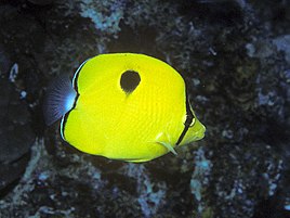
File:Bep chaetodon kleinii pemba.jpg|Sunburst butterflyfish |
File:Bep chaetodon kleinii pemba.jpg|[[Sunburst butterflyfish]] (''Chaetodon kleinii'') |
||
File:Bep chaetodon unimaculatus pemba.jpg|Yellow |
File:Bep chaetodon unimaculatus pemba.jpg|[[Yellow teardrop butterflyfish]] (''Chaetodon interruptus'') |
||
</gallery> |
</gallery> |
||
| Line 172: | Line 194: | ||
==References== |
==References== |
||
{{ |
{{Reflist}} |
||
==External links== |
==External links== |
||
| Line 180: | Line 202: | ||
{{Tanzania topics}} |
{{Tanzania topics}} |
||
{{Authority control}} |
|||
[[Category:Pemba Island| ]] |
[[Category:Pemba Island| ]] |
||
| Line 186: | Line 209: | ||
[[Category:Islands of Tanzania]] |
[[Category:Islands of Tanzania]] |
||
[[Category:Important Bird Areas of the Zanzibar Archipelago]] |
[[Category:Important Bird Areas of the Zanzibar Archipelago]] |
||
[[Category:Former sultanates]] |
|||
[[Category:Island countries]] |
|||
Latest revision as of 08:15, 12 April 2024
Nickname: الجزيرة الخضراء Al Jazeera al Khizra (the green island)[citation needed] | |
|---|---|
 Vumawimbi Beach, Pemba Island | |
 Pemba Location in Tanzania  Pemba Pemba (Africa) | |
| Geography | |
| Location | Indian Ocean |
| Coordinates | 5°10′S 39°47′E / 5.167°S 39.783°E |
| Area | 988 km2 (381 sq mi) |
| Highest elevation | 119 m (390 ft) |
| Highest point | Masingini Ridge |
| Administration | |
Tanzania | |
| Region | Zanzibar |
| Capital city | Chake Chake |
| Largest settlement | Wete |
| Demographics | |
| Population | 406,808 (census2012) |
| Pop. density | 428/km2 (1109/sq mi) |
| Additional information | |
| Official website | Country website |
Pemba Island (Arabic: الجزيرة الخضراء al-Jazīra al-khadrāʔ, literally "The Green Island"[citation needed]; Swahili: Pemba kisiwa) is a Tanzanian island forming part of the Zanzibar Archipelago, lying within the Swahili Coast in the Indian Ocean.
Geography[edit]

With a land area of 988 square kilometres (381 sq mi)[1] it is situated about 50 kilometres (31 mi) to the north of Unguja, the largest island of the archipelago. In 1964, Zanzibar was united with the former colony of Tanganyika to form Tanzania. It lies 50 kilometres (31 mi) east of mainland Tanzania, across the Pemba Channel. Together with Mafia Island (south of Unguja), these islands form the Spice Islands (not to be confused with the Maluku Islands of Indonesia).
Most of the island, which is hillier and more fertile than Unguja, is dominated by small scale farming. There is also large scale farming of cash crops such as cloves.
In previous years, the island was seldom visited due to inaccessibility and a reputation for political violence,[citation needed] with the notable exception of those drawn by its reputation as a center for traditional medicine and witchcraft. There is a quite large Arab community on the island, who immigrated from Oman. The population is a mix of Arab and original Waswahili inhabitants of the island. A significant portion of the population also identifies as Shirazi people.[citation needed]
The most important towns in Pemba are Chake-Chake (the capital), Mkoani, and Wete, which is the largest city. The centrally located Chake-Chake is perched on a mound with a view to the west on a bay and the tiny Misali Island, where the tides determine when a dhow can enter the local harbour. Pemba is, with the exception of a strip of land along its eastern coast, a very fertile place: besides clove trees, the locals grow mainly rice, coconut, bananas, cassava, and red beans (called maharagwe in the Swahili language).
Pemba is home to several dive sites, with steep drop-offs, untouched coral, and very abundant marine life.[2][3]
Islets[edit]
- Fundo - is located few miles from Wete. It is the only inhabited island among the group of islets forming the north-west reef of Pemba. The other islets there include Njao, Kashani, Kokota, Funzi, and Uvinje.
- Njao - is the northernmost islet on the Fundo group. It is mainly used for agricultural purposes.
- Kashani - is on the same reef as Fundo but on the southernmost tip close to Ras Mkumbuu.
- Kokota - is located at the southern mouth of Wete port.
- Funzi - lies east of Kokota and south of Uvinje island.
- Uvinje - is used for farming and located at the southern mouth of Wete port.
- Kiweni (Shamiani) - located on the south west part of Pemba, it is an uninhabited islet used mainly for farming and livestock grazing. On its southernmost tip it has a very fine beach and some prospective investors were building a hotel in the late 1990s.
- Kojani - is the only inhabited island on the western side of Pemba island. It is home to some skilled artisanal fishermen in East Africa who seasonally travel to most parts of the coast in search of schools of fish to catch.
- Kwata - the island was the site of the first major outbreak of cholera in 1978 when travelers were temporarily quarantined at this island before being allowed into Pemba.
- Makoongwe - is few kilometers from Mkoani. It has characteristics similar to the opposite area on the island of Pemba with deep soils and hilly terrain. Makoongwe is inhabited and people do farming and fishing.
- Matumbini - is an islet with dense mangrove forest and popular among fishermen due to the presence of rich coral reef.
- Misali - has a rich coral reef, and has been declared a marine reserve.
- Mwangi - is a small islet close to Mtambwe on the main island of Pemba.
- Panza - is the southernmost island in Pemba and in fact is a series of islets but a bridge connects the two main parts of Mtondooni and Panza proper. Its topography is coral on the Panza side and deep soil on the Mtondooni part. Its inhabitants do farming and fishing.
- Vikunguni - is a small islet close to the north-west group of islands.
- Yombi - is a small islet east of Panza island.
Important Bird Area[edit]
Pemba has been designated an Important Bird Area (IBA) by BirdLife International because it supports populations of Pemba green pigeons, Pemba scops owls, Pemba white-eyes and Pemba sunbirds.[4]
Climate[edit]
Pemba has a tropical climate, yet somewhat milder than Tanzania's mainland and milder than in Unguja island. This climate is classified as "Aw" by the Köppen-Geiger system. The average temperature in Chake Chake is 25.5 °C (78 °F). The average annual rainfall is 1,364 mm. The monthly average temperatures are usually between 24 and 27.4 °C (75 °F and 81 °F). There are two rain seasons, with most rainfall coming between April and May and smaller rain season coming between November and December. Drier months are January and February, and a longer drier season between June and October.
| Climate data for Chake Chake | |||||||||||||
|---|---|---|---|---|---|---|---|---|---|---|---|---|---|
| Month | Jan | Feb | Mar | Apr | May | Jun | Jul | Aug | Sep | Oct | Nov | Dec | Year |
| Mean daily maximum °C (°F) | 30.9 (87.6) |
31.6 (88.9) |
31.9 (89.4) |
30.1 (86.2) |
28.9 (84.0) |
28.5 (83.3) |
27.8 (82.0) |
28.1 (82.6) |
28.8 (83.8) |
29.7 (85.5) |
30.2 (86.4) |
30.8 (87.4) |
29.8 (85.6) |
| Daily mean °C (°F) | 26.8 (80.2) |
27.1 (80.8) |
27.4 (81.3) |
26.3 (79.3) |
25.3 (77.5) |
24.6 (76.3) |
23.7 (74.7) |
23.7 (74.7) |
24.1 (75.4) |
25.0 (77.0) |
25.9 (78.6) |
26.6 (79.9) |
25.5 (77.9) |
| Mean daily minimum °C (°F) | 22.8 (73.0) |
22.7 (72.9) |
22.9 (73.2) |
22.6 (72.7) |
21.8 (71.2) |
20.7 (69.3) |
19.7 (67.5) |
19.3 (66.7) |
19.5 (67.1) |
20.3 (68.5) |
21.6 (70.9) |
22.5 (72.5) |
21.4 (70.5) |
| Average precipitation mm (inches) | 86 (3.4) |
71 (2.8) |
134 (5.3) |
304 (12.0) |
291 (11.5) |
74 (2.9) |
42 (1.7) |
27 (1.1) |
21 (0.8) |
54 (2.1) |
129 (5.1) |
131 (5.2) |
1,364 (53.7) |
| Source: Climate-Data.ORG[5] | |||||||||||||
Archaeology[edit]

Archaeological research on Pemba has shown its centrality to the Swahili coast trading system as early as 600 AD.[6] Along the northern coast, urban settlements at Chwaka later developed and flourished from the eleventh century to ~1500 AD.[7]
West of Pemba's capital Chake-Chake, on a long stretched peninsula called Ras Mkumbuu, one can find some of the oldest and best preserved series of early ruins on the islands (Ndagoni ruins, probably 14th century).[8]
East of Chake-Chake one can find the Mkama Ndume ruins at Pujini village (south of the airport) within easy reach by road from Chake-Chake. This is the only known early fortification on the whole Swahili Coast; it is dated to the fifteenth century.[9]
History[edit]


According to the Arab geographer Yakut, in the mid-13th century there were two independent sultans ruling over parts of Pemba Island.[10]
On 24 June 2016, the Australian Minister for Infrastructure, Transport and Regional Development, Darren Chester, said that a piece of aircraft debris was found on Pemba Island, possibly being from the missing Malaysia Airlines Flight 370.[11]
Administration[edit]

Pemba is part of the semi-autonomous Revolutionary Government of Zanzibar.[12] Administratively, it is divided into two regions, North Pemba (Pemba Kaskazini)with its capital at Wete,[13] and South Pemba (Pemba Kusini) with its capital at Mkoani.[14] Although the centrally located city of Chake Chake, near the airport, is considered Pemba's capital,[15][16] and is the seat of Pemba's court and the President of Zanzibar's official Pemba residence.[citation needed]
Economy[edit]
Fishing[edit]
Pemba is also famous for its rich fishing grounds. Between the island and the mainland there is the deep 50 kilometre wide Pemba Channel, which is one of the most profitable fishing grounds for game fishing on the Swahili Coast.[17]
Farming and agriculture[edit]
Pemba is (with the exception of a strip of land along its eastern coast) highly fertile for agriculture which serves the global farming industry.
Cash crops[edit]
A large segment of Zanzibar export earnings comes from cloves. The greatest concentration of clove trees in Zanzibar is found on Pemba (3.5 million trees), as growing conditions on the island are superior to those on Unguja island. Clove trees grow to a height of approximately 10 to 15 metres and can be harvested for sometimes over 50 years.[citation needed] Most of the island, which is hillier and more fertile than Unguja, is dominated by small scale farming. There is also large-scale farming of other crops, primarily rice, coconuts, and red beans (called maharagwe in Swahili), as well as cassava and bananas.
Land surveying[edit]
For the promotion of tourism, the Department of Surveys and Mapping at Chake-Chake has been publishing maps with tourist guides since 1992.[18]
Transport[edit]
Airport[edit]
Pemba Airport is also known as Wawi Airport or Karume Airport and connects the island to Arusha, Dar es Salaam, and Zanzibar City.
Gallery[edit]
-
 Island near Chake Chake
 -
 A wharf at Mkoani during the daytime with fishing nets being dried in the sun
 -
 An example of clove buds being dried in the equatorial sun
 -
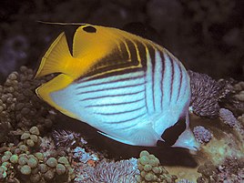 Threadfin butterflyfish (Chaetodon auriga). Underwater photograph at Pemba island
 -
 Sunburst butterflyfish (Chaetodon kleinii)
 -
 Yellow teardrop butterflyfish (Chaetodon interruptus)


See also[edit]
References[edit]
- ^ Tanzania in figures 2012, National Bureau of Statistics, Ministry of Finance, June 2013, page 7 Archived 2013-11-26 at the Wayback Machine
- ^ "Africa: Dive of a lifetime on Pemba Island". 2 March 2010. Retrieved 11 March 2012.
- ^ "Divernet: Fun at Fundu". Archived from the original on 17 October 2011. Retrieved 11 March 2012.
- ^ "Pemba Island". BirdLife Data Zone. BirdLife International. 2021. Retrieved 27 February 2021.
- ^ "Chake Chake". Retrieved July 26, 2017.
- ^ Fleisher, Jeffrey; LaViolette, Adria (2013). "The early Swahili trade village of Tumbe, Pemba Island, Tanzania, AD 600–950". Antiquity. 87 (338): 1151–1168. doi:10.1017/S0003598X00049929. S2CID 163370129.
- ^ LaViolette, Adria; Fleisher, Jeffrey (2009). "The Urban History of a Rural Place: Swahili Archaeology on Pemba Island, Tanzania, 700–1500 AD". International Journal of African Historical Studies. 42 (3): 433–455.
- ^ Kirkman, James S. "Excavations at Ras Mkumbuu on the island of Pemba." Tanganyika Notes and Records 53 (1959): 161-78.
- ^ LaViolette, Adria (2004). Swahili archaeology and history on Pemba, Tanzania: A critique and case study of the use of written and oral sources in archaeology. In Reid, Andrew M. and Paul J. Lane, eds. African Historical Archaeologies, pp. 125-162.
- ^ Marina Tolmacheva, The Pate Chronicle (East Lansing: Michigan State University Press, 1993) p. 6
- ^ "Potential MH370 debris found on island off African coast". The Washington Post. Associated Press. 24 June 2016. Archived from the original on 25 June 2016. Retrieved 24 June 2016.
- ^ "The Constitution of The United Republic of Tanzania (PDF)". Centre for Human Rights, University of Pretoria. Archived from the original (PDF) on 2012-07-22. Retrieved 2009-09-01.
- ^ "Tanzania Regional Profiles: Kaskazini Pemba Profile". The United Republic of Tanzania. 2016. Archived from the original on 14 November 2017.
- ^ "Tanzania Regional Profiles: Kusini Pemba Profile". The United Republic of Tanzania. 2016. Archived from the original on 14 November 2017.
- ^ "Pemba Surrounding Islands". Zanzibar's Airports Authority. Archived from the original on 19 September 2020.
- ^ "A Trip to Pemba" (PDF). The Fumba Times. No. June–August, 2019. p. 8. Archived (PDF) from the original on 21 January 2021.
- ^ "The Pemba Channel Fishing Club". Archived from the original on 25 April 2012. Retrieved 8 October 2011.
- ^ Pemba - The clove island 1:100,000, Map & Guide, 3rd edition, 2013, Dept. of Surveys and Mapping, Box 235, Chake-Chake
External links[edit]
- Short documentary about Pemba Island on YouTube
- Audio interview with Pemba Island resident about life on Pemba Island

| International | |
|---|---|
| National | |