
El Yunque (Puerto Rico): Difference between revisions
Litrobotix (talk | contribs) m it's > its |
|||
| (48 intermediate revisions by 23 users not shown) | |||
| Line 1: | Line 1: | ||
{{ |
{{Short description|Mountain in Puerto Rico}} |
||
{{use mdy dates|date=June 2022}} |
|||
:''This article refers to the mountain. For information on the national forest, see [[El Yunque National Forest]].'' |
|||
{{Infobox mountain |
{{Infobox mountain |
||
| name = |
| name = El Yunque |
||
| photo = |
| photo = Clearer view of Yunque's top from the Yokahú Tower.jpg |
||
| ⚫ | |||
| photo_caption = <small>El Yunque peak</small> |
|||
| ⚫ | |||
| elevation_ref = |
| elevation_ref = |
||
| prominence_m |
| prominence_m = |
||
| prominence_ref= |
| prominence_ref = |
||
| range = [[Sierra de Luquillo]] |
| range = [[Sierra de Luquillo]] |
||
| listing = |
| listing = |
||
| Line 14: | Line 13: | ||
| map = USA Puerto Rico |
| map = USA Puerto Rico |
||
| range_coordinates = |
| range_coordinates = |
||
| coordinates |
| coordinates = {{coord|18|18|38|N|65|47|29|W|type:mountain_region:US-PR_scale:100000|format=dms|display=inline,title}} |
||
| coordinates_ref = |
| coordinates_ref = |
||
| topo = |
| topo = |
||
| Line 20: | Line 19: | ||
| age = |
| age = |
||
| first_ascent = |
| first_ascent = |
||
| easiest_route = Hike |
| easiest_route = [[El Yunque National Forest|Hike]] |
||
| photo_caption = View of El Yunque from the Yokahú Tower in [[Río Grande, Puerto Rico]] |
|||
| parent_peak = [[El Toro (Sierra de Luquillo)|El Toro]] |
|||
| etymology = {{Lang|tnq|[[Yúcahu]]}} phonetic Spanish transliteration of [[Taíno language|Taíno]] possibly meaning '[[Cloud forest|white]] land' and/or {{Lang|es|El Yunque}} meaning 'the [[anvil]]' in [[Spanish language|Spanish]] due to the shape of the mountain range when seen from the south. |
|||
| native_name = |
|||
}} |
}} |
||
''' |
'''El Yunque''' or '''El Yunque Peak''' ([[Spanish language|Spanish]]: '''''Pico El Yunque''''') ([[Taíno language|Taíno]]: ''Yukiyu''<ref>{{Cite web|title=Taino Petroglyphs on the Rio Blanco in Puerto Rico near Naguabo|url=https://elyunque.com/1d.html|access-date=2021-10-20|website=elyunque.com}}</ref>) is a mountain located fully within the boundaries of the [[El Yunque National Forest]], part of the [[U.S. Forest Service]], which is the only [[tropical rainforest]] under the [[United States Forest Service|U.S. Forest Service]] jurisdiction. It is located in the municipality of [[Río Grande, Puerto Rico|Río Grande]]. |
||
| ⚫ | |||
Its name is [[Spanish language|Spanish]] for "The Anvil". |
|||
It is accessible via Mt Britton trail near the end of PR 191, which starts in PR 3 in the small town of Palmer. The best access from San Juan is via [[Puerto Rico Highway 66|PR 66]] toll express in 1 hr. which exits to PR 3. At the end of PR 191 in El Yunque there is a loop that goes to the entrance of the Mt Britton trail - close to El Yunque peak. It is one of the few places close to this trail with about 15 parking spots. |
|||
== Neighboring Peaks== |
|||
*[[Cerro de Punta]] (1,338 m 4,390 ft) |
|||
This trail is mostly paved and leads to the Mt Britton tower, the Three Peaks (Tres Picachos), the spur trail, and finally El Yunque peak with communications systems (towers) and then a small tower in the peak. The main road PR 191 has a gate at the end and after this there is a maintenance road to El Yunque and then the closed section of PR 191 which is about 3 hours long - a road that is being reclaimed by the forest and is closed due to a massive landslide. There is also the entrance the Tradewinds trail - possibly the longest trail of the park, which ends in El Toro Peak. |
|||
* Toro Negro (1,074 m 3533 ft) |
|||
* Pico Del Oeste (1,056m (3,446 ft) |
|||
Its summit provides views of the other peaks of El Yunque, the vast rainforest below, and the rest of the island. The river in PR 191 called Quebrada Juan Diego is just below this peak and has a trails, waterfalls and ponds. |
|||
* El Cacique (1,020m 3,346 ft) |
|||
* Mount Briton (937m 3,075 ft) |
|||
==Background== |
|||
* La Mina de Pantalones (931m 3,055 ft) |
|||
[[File:Mt Britton in El Yunque.jpg|thumb|View of Mt Britton]] |
|||
[[File:Awesome view form the Three Peaks in El Yunque.jpg|thumb|El Yunque peak has this smaller peak called Los Tres Picachos and this is the amazing view from here - accessible via the Mt Britton Spur Trail or El Yunque trail.]] |
|||
The peak itself, standing at {{convert|1080|m|ft|abbr=off}} above sea level is not the highest in Puerto Rico or even the [[Sierra de Luquillo]] range where it is located. It is however the most famous peak due to its curious shape, its natural environment and history, and for its cultural importance to the [[Taíno|Taino]] people. The peak is nearly always covered in thin mist and due to its high humidity, a quick shower develops during some afternoons. The hike to the top from the Mina Falls is not challenging yet it takes almost {{frac|4|1|2}} hours. |
|||
This peak is located on the El Yunque massif which also contains other smaller peaks such as [[Mount Britton (Puerto Rico)|Mount Britton]], Juan Diego Peak and the Roca del Yunque which is a rocky peak close to the summit of El Yunque. El Yunque massif itself is part of the [[Sierra de Luquillo]]. The highest point in the Sierra de Luquillo is [[El Toro (Sierra de Luquillo)|El Toro]] ([[Spanish language|Spanish]] for ''the bull'') located in the municipal boundary between Río Grande and [[Las Piedras, Puerto Rico|Las Piedras]], which lends its name to the [[El Toro Wilderness]]. |
|||
==Climate== |
==Climate== |
||
| ⚫ | El Yunque is classified as having a [[tropical rainforest climate]], [[Köppen climate classification|Köppen climate]] type 'Af', along with surrounding areas, approximating a [[subtropical highland climate]] at the peak. The average temperature of the park is 70 °F, and seasonal variation virtually nonexistent. The rugged area can receive over 200 inches (5080 millimeters) of annual rainfall and is the rainiest of all US national forests.<ref>{{Cite web|url=https://www.fs.usda.gov/detail/elyunque/about-forest/?cid=fsbdev3_042985|title=About the Forest MAIN|website=USDA Forest Service|language=en|access-date=2020-03-25}} USDA Forest Service</ref><ref name=weather_naguabo/><ref>{{Cite web|url=http://welcome.topuertorico.org/reference/yunque.shtml|title=El Yunque, Puerto Rico|website=welcome.topuertorico.org|language=en|access-date=2018-10-30}}</ref> |
||
[[File:El Yunque close-up.jpg|thumb|El Yunque view from Yokahu Tower on a clear day|250px]] |
|||
| ⚫ | El Yunque is classified as having a [[tropical rainforest climate]], [[Köppen climate classification|Köppen climate]] type 'Af', along with surrounding areas. The average temperature of the park is |
||
==Gallery== |
|||
<gallery> |
|||
| ⚫ | |||
File:Pico El Yunque.jpg|El Yunque massif with Pico El Yunque, Roca El Yunque and Mount Britton. |
|||
File:View of El Yunque from Britton Tower in Puerto Rico.jpg|El Yunque view from Mount Britton Tower. |
|||
File:Puerto Rico El Yunque 4.jpg|El Yunque from the north. |
|||
File:Flickr - ggallice - Window to El Yunque.jpg|El Yunque from [[Yokahú Tower|Yocahu Tower]]. |
|||
File:Top of El Yunque, from the Yokahú Tower, an observation tower built in 1963.jpg|[[Los Picachos]] (left) and El Yunque (right) covered in fog. |
|||
File:Northeast Ecological Corridor and El Yunque National Forest.jpg|El Yunque from the [[Northeast Ecological Corridor]]. |
|||
File:El Yunque close-up.jpg |
|||
</gallery> |
|||
==See also== |
==See also== |
||
| ⚫ | |||
* [[El Yunque National Forest]] |
* [[El Yunque National Forest]] |
||
==References== |
==References== |
||
{{ |
{{Reflist|refs= |
||
| ⚫ | |||
<ref name=weather_naguabo> |
|||
| ⚫ | |||
| title = Naguabo, Puerto Rico| publisher = weatherbase.com | accessdate = 25 January 2015}}</ref> |
|||
}} |
}} |
||
{{commons cat}} |
|||
==External links== |
|||
| ⚫ | |||
* {{Commons category-inline}} |
|||
| ⚫ | |||
{{Authority control}} |
|||
[[Category:Mountains of Puerto Rico]] |
[[Category:Mountains of Puerto Rico]] |
||
[[Category:Río Grande, Puerto Rico]] |
[[Category:Río Grande, Puerto Rico]] |
||
| ⚫ | |||
[[Category:Protected areas of Puerto Rico]] |
|||
{{PuertoRico-geo-stub}} |
|||
[[Category:Puerto Rican folklore]] |
|||
Revision as of 04:51, 14 May 2024
| El Yunque | |
|---|---|
View of El Yunque from the Yokahú Tower in Río Grande, Puerto Rico | |
| Highest point | |
| Elevation | 1,080 m (3,540 ft) |
| Parent peak | El Toro |
| Coordinates | 18°18′38″N 65°47′29″W / 18.31056°N 65.79139°W |
| Naming | |
| Etymology | Yúcahu phonetic Spanish transliteration of Taíno possibly meaning 'white land' and/or El Yunque meaning 'the anvil' in Spanish due to the shape of the mountain range when seen from the south. |
| Geography | |
 El Yunque | |
| Parent range | Sierra de Luquillo |
| Climbing | |
| Easiest route | Hike |
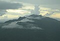
El Yunque or El Yunque Peak (Spanish: Pico El Yunque) (Taíno: Yukiyu[1]) is a mountain located fully within the boundaries of the El Yunque National Forest, part of the U.S. Forest Service, which is the only tropical rainforest under the U.S. Forest Service jurisdiction. It is located in the municipality of Río Grande.
It is accessible via Mt Britton trail near the end of PR 191, which starts in PR 3 in the small town of Palmer. The best access from San Juan is via PR 66 toll express in 1 hr. which exits to PR 3. At the end of PR 191 in El Yunque there is a loop that goes to the entrance of the Mt Britton trail - close to El Yunque peak. It is one of the few places close to this trail with about 15 parking spots.
This trail is mostly paved and leads to the Mt Britton tower, the Three Peaks (Tres Picachos), the spur trail, and finally El Yunque peak with communications systems (towers) and then a small tower in the peak. The main road PR 191 has a gate at the end and after this there is a maintenance road to El Yunque and then the closed section of PR 191 which is about 3 hours long - a road that is being reclaimed by the forest and is closed due to a massive landslide. There is also the entrance the Tradewinds trail - possibly the longest trail of the park, which ends in El Toro Peak.
Its summit provides views of the other peaks of El Yunque, the vast rainforest below, and the rest of the island. The river in PR 191 called Quebrada Juan Diego is just below this peak and has a trails, waterfalls and ponds.
Background


The peak itself, standing at 1,080 metres (3,540 feet) above sea level is not the highest in Puerto Rico or even the Sierra de Luquillo range where it is located. It is however the most famous peak due to its curious shape, its natural environment and history, and for its cultural importance to the Taino people. The peak is nearly always covered in thin mist and due to its high humidity, a quick shower develops during some afternoons. The hike to the top from the Mina Falls is not challenging yet it takes almost 4+1⁄2 hours.
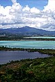
This peak is located on the El Yunque massif which also contains other smaller peaks such as Mount Britton, Juan Diego Peak and the Roca del Yunque which is a rocky peak close to the summit of El Yunque. El Yunque massif itself is part of the Sierra de Luquillo. The highest point in the Sierra de Luquillo is El Toro (Spanish for the bull) located in the municipal boundary between Río Grande and Las Piedras, which lends its name to the El Toro Wilderness.
Climate
El Yunque is classified as having a tropical rainforest climate, Köppen climate type 'Af', along with surrounding areas, approximating a subtropical highland climate at the peak. The average temperature of the park is 70 °F, and seasonal variation virtually nonexistent. The rugged area can receive over 200 inches (5080 millimeters) of annual rainfall and is the rainiest of all US national forests.[2][3][4]
Gallery
-
 Morning mist in El Yunque rainforest by El Yunque peak.
 -
 El Yunque massif with Pico El Yunque, Roca El Yunque and Mount Britton.
 -
 El Yunque view from Mount Britton Tower.
 -
 El Yunque from the north.
 -
 El Yunque from Yocahu Tower.
 -
 Los Picachos (left) and El Yunque (right) covered in fog.
 -
 El Yunque from the Northeast Ecological Corridor.
 -


See also
References
- ^ "Taino Petroglyphs on the Rio Blanco in Puerto Rico near Naguabo". elyunque.com. Retrieved October 20, 2021.
- ^ "About the Forest MAIN". USDA Forest Service. Retrieved March 25, 2020. USDA Forest Service
- ^ "Naguabo, Puerto Rico". weatherbase.com. Retrieved January 25, 2015.
- ^ "El Yunque, Puerto Rico". welcome.topuertorico.org. Retrieved October 30, 2018.
External links
 Media related to El Yunque (Puerto Rico) at Wikimedia Commons
| International | |
|---|---|
| National | |