
Diffa: Difference between revisions
m Removing from Category:Populated places in Niger using Cat-a-lot |
Athrictoss (talk | contribs) No edit summary |
||
| (6 intermediate revisions by 5 users not shown) | |||
| Line 49: | Line 49: | ||
|unit_pref =Imperial <!--Enter: Imperial, if Imperial (metric) is desired--> |
|unit_pref =Imperial <!--Enter: Imperial, if Imperial (metric) is desired--> |
||
|area_footnotes = |
|area_footnotes = |
||
|area_total_km2 = |
|area_total_km2 = 355.4 |
||
|area_land_km2 = <!--See table @ Template:Infobox Settlement for details on automatic unit conversion--> |
|area_land_km2 = <!--See table @ Template:Infobox Settlement for details on automatic unit conversion--> |
||
<!-- Population -----------------------> |
<!-- Population -----------------------> |
||
|population_as_of = |
|population_as_of =2012 census |
||
|population_footnotes =<ref>[http://www.citypopulation.de/Niger.html Population figures from citypopulation.de], citing [http://www.stat-niger.org/ ( |
|population_footnotes =<ref>[http://www.citypopulation.de/Niger.html Population figures from citypopulation.de], citing [http://www.stat-niger.org/ (2012) Institut National de la Statistique du Niger].</ref> |
||
|population_note = |
|population_note = |
||
|population_total = |
|population_total =56,437 |
||
| |
|population_urban =39,960 |
||
|population_density_km2 = auto |
|||
|population_density_sq_mi = |
|population_density_sq_mi = |
||
|population_metro = |
|population_metro = |
||
| Line 85: | Line 86: | ||
|footnotes = |
|footnotes = |
||
}} |
}} |
||
'''Diffa''' is a city and [[Communes of Niger|Urban Commune]] in the extreme southeast of [[Niger]], near the border with [[Nigeria]]. It is the administrative seat of both [[Diffa Region]], and the smaller [[Diffa Department]].<ref name="Bradt">Geels, Jolijn, (2006) ''Bradt Travel Guide - Niger'', pgs. 229-31</ref><ref name="Historical Dictionary">Idrissa, Abdourahmane & Decalo, Samuel, ''Historical Dictionary of Niger'' (4th ed.). Scarecrow Press, Boston & Folkestone, (2012) {{ISBN|0-8108-3136-8}}</ref> {{as of| |
'''Diffa''' is a city and [[Communes of Niger|Urban Commune]] in the extreme southeast of [[Niger]], near the border with [[Nigeria]]. It is the administrative seat of both [[Diffa Region]], and the smaller [[Diffa Department]].<ref name="Bradt">Geels, Jolijn, (2006) ''Bradt Travel Guide - Niger'', pgs. 229-31</ref><ref name="Historical Dictionary">Idrissa, Abdourahmane & Decalo, Samuel, ''Historical Dictionary of Niger'' (4th ed.). Scarecrow Press, Boston & Folkestone, (2012) {{ISBN|0-8108-3136-8}}</ref> {{as of|2012}}, the commune had a total population of 56,437 people.<ref>{{cite web|url=http://www.stat-niger.org/statistique/file/Annuaires_Statistiques/Annuaire_ins_2011/population.pdf|title=Annuaires_Statistiques|publisher=[[Institut National de la Statistique du Niger]]|access-date=2 May 2013}}</ref> |
||
==History== |
==History== |
||
In 2002, it was the centre of the first military uprising in the country since President [[Tandja Mamadou]] instituted civilian rule |
In 2002, it was the centre of the first military uprising in the country since President [[Tandja Mamadou]] instituted civilian rule; the uprising led to a government crackdown against the civilian press.<ref>[http://www.irinnews.org/report.aspx?reportid=33269 NIGER: Army mutineers free civilian hostages]. 2 August 2002 (IRIN)</ref><ref>[http://cpj.org/2003/03/attacks-on-the-press-2002-niger.php Attacks on the Press 2002: Niger]. Committee to Protect Journalists. 31 March 2003</ref><ref>[https://archive.today/20110522150430/http://www.voanews.com/english/archive/2002-08/a-2002-08-01-30-Niger-s.cfm Niger's Army Pursuing Mutinous Soldiers]. Voice of America. 1 August 2002</ref> |
||
=== Nigerian refugees === |
=== Nigerian refugees === |
||
In recent years refugees from Nigeria fleeing violence from [[Boko Haram]] have settled in Diffa and surrounding area.<ref>{{Cite web |
In recent years, refugees from Nigeria fleeing violence from [[Boko Haram]] have settled in Diffa and surrounding area.<ref>{{Cite web |
||
| last = Damon |
| last = Damon |
||
| first = Arwa |
| first = Arwa |
||
| title = Where are Nigeria's missing girls? On the hunt for Boko Haram |
| title = Where are Nigeria's missing girls? On the hunt for Boko Haram |
||
| work = CNN.com |
| work = CNN.com |
||
| |
| access-date = 12 June 2014 |
||
| date = 11 June 2014 |
| date = 11 June 2014 |
||
| url = http://www.cnn.com/2014/06/10/world/africa/boko-haram-hunt-arwa-damon/index.html?iid=article_sidebar |
| url = http://www.cnn.com/2014/06/10/world/africa/boko-haram-hunt-arwa-damon/index.html?iid=article_sidebar |
||
| Line 104: | Line 105: | ||
[[File:Diffa grand Marché.JPG|thumb|The ''Grand Marché'']] |
[[File:Diffa grand Marché.JPG|thumb|The ''Grand Marché'']] |
||
Diffa is situated on the north bank of the [[Komadougou Yobe]] river; the river's seasonal floodplain lies immediately to the south and east.<ref name="Bradt"/> Much of the riverbank is lined with gardens and small allotments which grow the town's well-known red peppers.<ref name="Historical Dictionary"/><ref name="Bradt"/> The town is bisected in an arc by the Route Nationale 1 road; the eastern part of town is centred on the ''Grand Marché'', which also acts as the transport hub for the city.<ref name="Bradt"/> |
Diffa is situated on the north bank of the [[Komadougou Yobe]] river; the river's seasonal floodplain lies immediately to the south and east.<ref name="Bradt"/> Much of the riverbank is lined with gardens and small allotments which grow the town's well-known red peppers.<ref name="Historical Dictionary"/><ref name="Bradt"/> The town is bisected in an arc by the Route Nationale 1 road; the eastern part of town is centred on the ''Grand Marché'', which also acts as the transport hub for the city.<ref name="Bradt"/> |
||
===Climate=== |
|||
Diffa has a hot climate with a wet and dry season. On 7 September 1978, Diffa recorded a temperature of {{convert|49.5|C|F}}, which is the highest temperature to have ever been recorded in Niger.<ref name=nigerCC>{{cite web |archive-url=https://web.archive.org/web/20180506213909/https://unfccc.int/files/national_reports/non-annex_i_natcom/submitted_natcom/application/pdf/nernc3.pdf |archive-date=6 May 2018 |url=https://unfccc.int/files/national_reports/non-annex_i_natcom/submitted_natcom/application/pdf/nernc3.pdf |title=Troisieme Communication Nationale A La Conference Des Parties De La Conventioncadre Des Nations Unies Sur Les Changements Climatiques |publisher=Republique de Niger |page=8 |access-date=16 April 2022}}</ref> |
|||
==Architecture== |
==Architecture== |
||
| Line 128: | Line 132: | ||
{{coord|13|18|53|N|12|37|4|E|region:NE_type:city|display=title}} |
{{coord|13|18|53|N|12|37|4|E|region:NE_type:city|display=title}} |
||
{{Communes of Niger}} |
{{Communes of Niger}} |
||
{{Authority control}} |
|||
[[Category:Communes of Niger]] |
[[Category:Communes of Niger]] |
||
Latest revision as of 13:35, 18 May 2024
Diffa | |
|---|---|
Urban Commune | |
 Diffa Location in Niger | |
| Coordinates: 13°18′53″N 12°37′4″E / 13.31472°N 12.61778°E | |
| Country | |
| Region | Diffa Region |
| Department | Diffa Department |
| Urban Commune | Diffa |
| Area | |
| • Urban Commune | 137.2 sq mi (355.4 km2) |
| Elevation | 938 ft (285 m) |
| Population (2012 census)[1] | |
| • Urban Commune | 56,437 |
| • Density | 410/sq mi (160/km2) |
| • Urban | 39,960 |
| Time zone | UTC+1 (WAT) |
Diffa is a city and Urban Commune in the extreme southeast of Niger, near the border with Nigeria. It is the administrative seat of both Diffa Region, and the smaller Diffa Department.[2][3] As of 2012[update], the commune had a total population of 56,437 people.[4]
History
[edit]In 2002, it was the centre of the first military uprising in the country since President Tandja Mamadou instituted civilian rule; the uprising led to a government crackdown against the civilian press.[5][6][7]
Nigerian refugees
[edit]In recent years, refugees from Nigeria fleeing violence from Boko Haram have settled in Diffa and surrounding area.[8]
Geography
[edit]
Diffa is situated on the north bank of the Komadougou Yobe river; the river's seasonal floodplain lies immediately to the south and east.[2] Much of the riverbank is lined with gardens and small allotments which grow the town's well-known red peppers.[3][2] The town is bisected in an arc by the Route Nationale 1 road; the eastern part of town is centred on the Grand Marché, which also acts as the transport hub for the city.[2]
Climate
[edit]Diffa has a hot climate with a wet and dry season. On 7 September 1978, Diffa recorded a temperature of 49.5 °C (121.1 °F), which is the highest temperature to have ever been recorded in Niger.[9]
Architecture
[edit]Sports buildings
[edit]
A traditional wrestling arena is located to the northeast of the Grand Marché.[2] Diffa Stadium can be found west of the RN1.[2]
Religious buildings
[edit]The town contains several mosques, most notably the Grande Mosquée de Diffa on the RN1.[2]
Transport
[edit]Diffa marks the eastern end of the paved section of Route Nationale 1, the main east-west highway across Niger, although the section between Zinder and Diffa is only partially paved in places.[2] RN1 continues north to N'guigmi more than 100 km. Maïné-Soroa, the other major town of the Region, lies less than 100 km to the west of Diffa. The border with Nigeria, at the Nigerian town of Duji, is 5.5 km to the south of Diffa. Diffa Airport lies to the north of the town.
Gallery
[edit]-
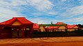 Headquarters of the Regional council
 -
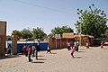 A school in Diffa
 -
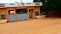 The Palais de Justice


References
[edit]- ^ Population figures from citypopulation.de, citing (2012) Institut National de la Statistique du Niger.
- ^ a b c d e f g h Geels, Jolijn, (2006) Bradt Travel Guide - Niger, pgs. 229-31
- ^ a b Idrissa, Abdourahmane & Decalo, Samuel, Historical Dictionary of Niger (4th ed.). Scarecrow Press, Boston & Folkestone, (2012) ISBN 0-8108-3136-8
- ^ "Annuaires_Statistiques" (PDF). Institut National de la Statistique du Niger. Retrieved 2 May 2013.
- ^ NIGER: Army mutineers free civilian hostages. 2 August 2002 (IRIN)
- ^ Attacks on the Press 2002: Niger. Committee to Protect Journalists. 31 March 2003
- ^ Niger's Army Pursuing Mutinous Soldiers. Voice of America. 1 August 2002
- ^ Damon, Arwa (11 June 2014). "Where are Nigeria's missing girls? On the hunt for Boko Haram". CNN.com. Retrieved 12 June 2014.
- ^ "Troisieme Communication Nationale A La Conference Des Parties De La Conventioncadre Des Nations Unies Sur Les Changements Climatiques" (PDF). Republique de Niger. p. 8. Archived from the original (PDF) on 6 May 2018. Retrieved 16 April 2022.
13°18′53″N 12°37′4″E / 13.31472°N 12.61778°E
| International | |
|---|---|
| National | |