
Felicity, California: Difference between revisions
m Reverted edit by 2600:1008:B1A5:A354:142:8E5:846:75B4 (talk) to last version by Adflatuss |
|||
| (44 intermediate revisions by 31 users not shown) | |||
| Line 1: | Line 1: | ||
{{Short description|Unincorporated community in California, United States}} |
|||
{{multiple issues| |
|||
{{ |
{{Use mdy dates|date=July 2023}} |
||
{{refimprove|date=October 2013}} |
|||
}} |
|||
| ⚫ | |||
{{Infobox settlement |
{{Infobox settlement |
||
<!--See the Table at Infobox Settlement for all fields and descriptions of usage--> |
<!--See the Table at Infobox Settlement for all fields and descriptions of usage--> |
||
<!-- Basic info ----------------> |
<!-- Basic info ----------------> |
||
|name = Felicity |
|name = Felicity, California |
||
|other_name = |
|other_name = |
||
|native_name = |
|native_name = |
||
|nickname = |
|nickname = |
||
|settlement_type =[[ |
|settlement_type =[[Unincorporated community]] |
||
|image_skyline = |
|image_skyline = |
||
|imagesize = |
|imagesize = |
||
|image_caption = |
|image_caption = |
||
|pushpin_map =California#USA |
|pushpin_map =California#USA |
||
|pushpin_label_position = |
|pushpin_label_position =top |
||
|pushpin_mapsize = |
|pushpin_mapsize = |
||
|pushpin_map_caption =Location in California |
|pushpin_map_caption =Location in California |
||
|pushpin_image= |
|pushpin_image= |
||
<!-- Location ------------------> |
<!-- Location ------------------> |
||
|coordinates_region =US-CA |
|||
|subdivision_type = Country |
|subdivision_type = Country |
||
|subdivision_name =[[United States]] |
|subdivision_name =[[United States]] |
||
| Line 34: | Line 30: | ||
|established_title = <!-- Settled --> |
|established_title = <!-- Settled --> |
||
|established_date = |
|established_date = |
||
| ⚫ | |||
|latd=32|latm=45|lats=01|latNS=N| |
|||
longd=114|longm=45|longs=55|longEW=W |
|||
|elevation_footnotes = <ref name=gnis>{{gnis|2025252}}</ref> |
|elevation_footnotes = <ref name=gnis>{{gnis|2025252}}</ref> |
||
|elevation_m =87 |
|elevation_m =87 |
||
| Line 41: | Line 36: | ||
|footnotes = |
|footnotes = |
||
}} |
}} |
||
'''Felicity''' is an [[unincorporated area|unincorporated community]] in [[Imperial County, California|Imperial County]], [[California]],<ref name=gnis /><ref>{{cite web |title= Desert monument captures history on stone | url= http://www.latimes.com/news/local/la-me-felicity16apr16,1,6734210.story | work= Los Angeles Times | date= 2008-04-16 | accessdate=2008-04-16 |archiveurl = http://web.archive.org/web/20080420071913/http://www.latimes.com/news/local/la-me-felicity16apr16,1,6734210.story <!-- Bot retrieved archive --> |archivedate = 2008-04-20}}</ref> |
|||
It lies at an elevation of 285 feet (87 m).<ref name=gnis /> |
|||
'''Felicity''' is an [[unincorporated area|unincorporated community]] in [[Imperial County, California]].<ref name=gnis /><ref name="LA-Times-1">{{cite news |last1=Anton |first1=Mike |title=See it now: the center of the world; The History of Humanity is being etched in stone in the California desert. The real story is the builder. |url=https://www.latimes.com/archives/la-xpm-2008-apr-16-me-felicity16-story.html |access-date=January 18, 2021 |work=[[Los Angeles Times]] |date=April 16, 2008 |archive-url=https://archive.today/20130127212639/http://www.latimes.com/news/local/la-me-felicity16apr16,1,6734210.story |archive-date=2013-01-27}}{{cbignore}}</ref> The town was established in 1986 by [[Jacques-Andre Istel]] who bought the land in the 1950s and developed it in the 1980s after selling off his parachute business. The town is "Dedicated to Remembrance" and named for Istel's wife Felicia.<ref name="mooallem">{{cite news |last1=Mooallem |first1=Jon |author1-link=Jon Mooallem |title=A Journey to the Center of the World |url=https://www.nytimes.com/2014/02/23/magazine/a-journey-to-the-center-of-the-world.html |access-date=17 January 2021 |work=[[The New York Times Magazine]] |date=19 February 2014 |archive-url=https://archive.today/20140903101456/http://www.nytimes.com/2014/02/23/magazine/a-journey-to-the-center-of-the-world.html |archive-date=3 September 2014 |url-status=unfit}}{{cbignore|bot=InternetArchiveBot}}</ref> It is 2,600 acres and lies at an elevation of 285 feet (87 m).<ref name=gnis /> |
|||
Founded on May 11, 1986, the Town "Dedicated to Remembrance" was named for his wife by founder Jacques-Andre Istel.It is accessible from [[Interstate 8 in California|Interstate 8]] in the far southeast of the state, just west of [[Yuma, Arizona|Yuma]], [[Arizona]]. |
|||
It is accessible from [[Interstate 8 in California|Interstate 8]] in the far southeast of the state, just west of [[Yuma, Arizona|Yuma]], [[Arizona]].<ref name="Burke">{{Cite web|last=Burke |first=Anne |date=2 January 2019 |title=A strange museum at the ‘centre of the world’ |publisher=BBC |url=http://www.bbc.com/travel/story/20190101-a-strange-museum-at-the-centre-of-the-world |archive-url=https://web.archive.org/web/20190106224923/http://www.bbc.com/travel/story/20190101-a-strange-museum-at-the-centre-of-the-world |archive-date=6 January 2019 |url-status=live |df=dmy}}</ref> |
|||
==Landmarks== |
|||
The [[Quechan]] Tribe of the [[Fort Yuma Indian Reservation]] is located nearby. During [[World War II]], the town was the site of [[Camp Pilot Knob]], the US Army's training center.<ref>{{cite web |title=Camp Pilot Knob, California |url=https://www.deserttrainingcenter.com/CampPilotKnob.html |website=[[Desert Training Center]] |access-date=17 January 2021}}</ref> |
|||
===The Sundial at Felicity=== |
|||
The town's key features are a {{convert|21|foot||adj=mid|-tall stone-and-glass pyramid}}, a church on a man-made hill, and the [[Museum of History in Granite]], which Istel has been developing since the town's founding. The museum consists of dozens of granite panels, most of them over 100 feet long and weighing approximately 500 tons. Etched on the panels is a historical record of humanity as chronicled by Istel. The lead artist on the project is Gene Britton.<ref name="mooallem"/> |
|||
The [[gnomon]] of the {{convert|15|ft|m|abbr=on}} [[Sundial]] at Felicity is a three-dimensional bronze of [[Michelangelo|Michelangelo's]] Arm of God painted on the [[Sistine Chapel]] ceiling. The arm was sculpted and cast in bronze in [[New England]]. The rock is local but the installation required the assistance of a mining engineer and a special drill. The bronze [[Roman numerals]] give the time. A sundial is precisely accurate once a year and this was set at noon on Christmas Day. The arm points to the Church on the Hill at Felicity. The Hill of Prayer was built in January 2002 by moving 150,000 tons of earth <ref name="latimes">{{cite news | first= Mike | last= Anton | title= Desert monument captures history on stone | url= http://www.latimes.com/news/local/la-me-felicity16apr16,1,6734210.story | work= Los Angeles Times | date= 2008-04-16 | accessdate=2008-04-16 |archiveurl = http://web.archive.org/web/20080420071913/http://www.latimes.com/news/local/la-me-felicity16apr16,1,6734210.story <!-- Bot retrieved archive --> |archivedate = 2008-04-20}}</ref> (engineered to earthquake zone 4 specifications). The church will remain the highest point in the town of Felicity now and in the future. |
|||
In May 1985, the Imperial County Board of Supervisors designated Felicity as the Official Center of the World.<ref name="LA-Times-1" /><ref name="Burke" /> |
|||
| ⚫ | |||
<gallery widths=220px heights=175px> |
|||
===Sculpture at entrance=== |
|||
| ⚫ | |||
| ⚫ | |||
The {{convert|25|ft|m|abbr=on}} high section number 12 of the original stairway of the [[Eiffel Tower]] is the entrance sculpture at Felicity.<ref name="latimes"/> In 1983, the [[France|government of France]] removed approximately {{convert|500|ft|m|abbr=on}} of the original stairway. Built with the technology of the 1860s, the weight of approximately {{convert|54000|lb|abbr=on}} was causing sway at the top of the then 94-year-old tower. Twenty sections were sold at auction on the tower on 1 December 1983. Most are in museums and a few in private hands. Section 12 was bought at auction in June 1989 at the [[Chateau de Cheverny]]. The installation of the {{convert|6600|lb|abbr=on}} section required engineering and a building permit. It serves no practical purpose, but is part of the spirit of Felicity.<ref name="latimes"/> |
|||
</gallery> |
|||
| ⚫ | |||
===The Felicity Post Office=== |
|||
The Felicity Post Office was dedicated on 5 December 1987 at a time when thousands of small post offices were being eliminated as an economy measure. The town, whose population numbered two, saw over 2,300 letters mailed that day. The dedication ceremony was highlighted by a speech in Chinese by Consul Zhou of the [[People's Republic of China]] who traveled {{convert|600|mi|km}} for the occasion. It is operated by the town at a cost to the federal government of one dollar per year. Twenty nine uncashed one dollar checks are on file. |
|||
===Museum of History in Granite=== |
|||
Nominated as a World Heritage Site the non-profit (tax deductible) [[Museum of History in Granite]] is the only such in the World. Time Magazine named the design "worth the trip". The red granite monuments, most 100 ft. long, are designed for 4000 years (no guarantee). Subjects include a 62 panel Korean War Memorial, the 62 panel Quest for the Sky - The History of French Aviation (Recipient of the Air and Space Medal in Europe in 2003), The 62 panel History of the French Foreign Legion, The 31 panel History of Arizona, The 31 panel History of California, The 62 panel Wall for the Ages includes the Hall of Fame of Parachuting.The 62 panel History of the United States of America earned a written A+ from a noted Historian. All are completed except the grand 416 panel History of Humanity on eight monuments laid out like a compass rose.Now 31% engraved, completion is scheduled for 2019. |
|||
Over 700 etchings have created a simultaneous art museum. |
|||
A smaller monument in the complex is the Felicity Stone, a Rosetta Stone for the future located at the center of the History of Humanity monuments. |
|||
==References== |
==References== |
||
| Line 74: | Line 56: | ||
==External links== |
==External links== |
||
* [http://www.felicityusa.com/ Felicity, CA Homepage] |
|||
* [http://www.roadsideamerica.com/attract/CAFEL.html Roadside America article] |
* [http://www.roadsideamerica.com/attract/CAFEL.html Roadside America article] |
||
* [http://www.hillofprayer.org/ The church on the hill at Felicity] |
* [http://www.hillofprayer.org/ The church on the hill at Felicity] |
||
* [http://www.bbc.com/travel/story/20190101-a-strange-museum-at-the-centre-of-the-world A strange museum at the centre of the world] |
|||
{{Clear}} |
|||
{{Imperial County, California}} |
{{Imperial County, California}} |
||
{{authority control}} |
|||
[[Category:Unincorporated communities in Imperial County, California]] |
[[Category:Unincorporated communities in Imperial County, California]] |
||
Latest revision as of 11:55, 19 June 2024
Felicity, California | |
|---|---|
 Felicity, California Location in California  Felicity, California Felicity, California (the United States) | |
| Coordinates: 32°45′01″N 114°45′55″W / 32.75028°N 114.76528°W | |
| Country | United States |
| State | California |
| County | Imperial County |
| Elevation | 285 ft (87 m) |
Felicity is an unincorporated community in Imperial County, California.[1][2] The town was established in 1986 by Jacques-Andre Istel who bought the land in the 1950s and developed it in the 1980s after selling off his parachute business. The town is "Dedicated to Remembrance" and named for Istel's wife Felicia.[3] It is 2,600 acres and lies at an elevation of 285 feet (87 m).[1]
It is accessible from Interstate 8 in the far southeast of the state, just west of Yuma, Arizona.[4]
The Quechan Tribe of the Fort Yuma Indian Reservation is located nearby. During World War II, the town was the site of Camp Pilot Knob, the US Army's training center.[5]
The town's key features are a 21-foot-tall stone-and-glass pyramid (6.4 m), a church on a man-made hill, and the Museum of History in Granite, which Istel has been developing since the town's founding. The museum consists of dozens of granite panels, most of them over 100 feet long and weighing approximately 500 tons. Etched on the panels is a historical record of humanity as chronicled by Istel. The lead artist on the project is Gene Britton.[3]
In May 1985, the Imperial County Board of Supervisors designated Felicity as the Official Center of the World.[2][4]
-
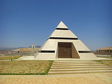 The pyramid houses the official center point.
 -
 Entrance to Center of the World Plaza


References
[edit]- ^ a b c U.S. Geological Survey Geographic Names Information System: Felicity, California
- ^ a b Anton, Mike (April 16, 2008). "See it now: the center of the world; The History of Humanity is being etched in stone in the California desert. The real story is the builder". Los Angeles Times. Archived from the original on January 27, 2013. Retrieved January 18, 2021.
- ^ a b Mooallem, Jon (February 19, 2014). "A Journey to the Center of the World". The New York Times Magazine. Archived from the original on September 3, 2014. Retrieved January 17, 2021.
{{cite news}}: CS1 maint: unfit URL (link) - ^ a b Burke, Anne (2 January 2019). "A strange museum at the 'centre of the world'". BBC. Archived from the original on 6 January 2019.
- ^ "Camp Pilot Knob, California". Desert Training Center. Retrieved January 17, 2021.
External links
[edit]- Roadside America article
- The church on the hill at Felicity
- A strange museum at the centre of the world
Municipalities and communities of Imperial County, California, United States | ||
|---|---|---|
| Cities |  | |
| CDPs | ||
| Unincorporated communities | ||
| Indian reservations | ||
| Ghost towns | ||
| Footnotes | ‡This populated place also has portions in an adjacent county or counties | |