
Felicity, California: Difference between revisions
added missing letter Tags: Mobile edit Mobile app edit Android app edit |
m Reverted edit by 2600:1008:B1A5:A354:142:8E5:846:75B4 (talk) to last version by Adflatuss |
||
| (25 intermediate revisions by 18 users not shown) | |||
| Line 1: | Line 1: | ||
{{Short description|Unincorporated community in California, United States}} |
|||
{{Use mdy dates|date=July 2023}} |
|||
{{Infobox settlement |
{{Infobox settlement |
||
<!--See the Table at Infobox Settlement for all fields and descriptions of usage--> |
<!--See the Table at Infobox Settlement for all fields and descriptions of usage--> |
||
<!-- Basic info ----------------> |
<!-- Basic info ----------------> |
||
|name = Felicity |
|name = Felicity, California |
||
|other_name = |
|other_name = |
||
|native_name = |
|native_name = |
||
|nickname = |
|nickname = |
||
|settlement_type =[[ |
|settlement_type =[[Unincorporated community]] |
||
|image_skyline = |
|image_skyline = |
||
|imagesize = |
|imagesize = |
||
| Line 34: | Line 37: | ||
}} |
}} |
||
'''Felicity''' is an [[unincorporated area|unincorporated community]] in [[Imperial County, |
'''Felicity''' is an [[unincorporated area|unincorporated community]] in [[Imperial County, California]].<ref name=gnis /><ref name="LA-Times-1">{{cite news |last1=Anton |first1=Mike |title=See it now: the center of the world; The History of Humanity is being etched in stone in the California desert. The real story is the builder. |url=https://www.latimes.com/archives/la-xpm-2008-apr-16-me-felicity16-story.html |access-date=January 18, 2021 |work=[[Los Angeles Times]] |date=April 16, 2008 |archive-url=https://archive.today/20130127212639/http://www.latimes.com/news/local/la-me-felicity16apr16,1,6734210.story |archive-date=2013-01-27}}{{cbignore}}</ref> The town was established in 1986 by [[Jacques-Andre Istel]] who bought the land in the 1950s and developed it in the 1980s after selling off his parachute business. The town is "Dedicated to Remembrance" and named for Istel's wife Felicia.<ref name="mooallem">{{cite news |last1=Mooallem |first1=Jon |author1-link=Jon Mooallem |title=A Journey to the Center of the World |url=https://www.nytimes.com/2014/02/23/magazine/a-journey-to-the-center-of-the-world.html |access-date=17 January 2021 |work=[[The New York Times Magazine]] |date=19 February 2014 |archive-url=https://archive.today/20140903101456/http://www.nytimes.com/2014/02/23/magazine/a-journey-to-the-center-of-the-world.html |archive-date=3 September 2014 |url-status=unfit}}{{cbignore|bot=InternetArchiveBot}}</ref> It is 2,600 acres and lies at an elevation of 285 feet (87 m).<ref name=gnis /> |
||
It is accessible from [[Interstate 8 in California|Interstate 8]] in the far southeast of the state, just west of [[Yuma, Arizona|Yuma]], [[Arizona]].<ref name="Burke">{{Cite web|last=Burke |first=Anne |date=2 January 2019 |title=A strange museum at the ‘centre of the world’ |publisher=BBC |url=http://www.bbc.com/travel/story/20190101-a-strange-museum-at-the-centre-of-the-world |archive-url=https://web.archive.org/web/20190106224923/http://www.bbc.com/travel/story/20190101-a-strange-museum-at-the-centre-of-the-world |archive-date=6 January 2019 | |
It is accessible from [[Interstate 8 in California|Interstate 8]] in the far southeast of the state, just west of [[Yuma, Arizona|Yuma]], [[Arizona]].<ref name="Burke">{{Cite web|last=Burke |first=Anne |date=2 January 2019 |title=A strange museum at the ‘centre of the world’ |publisher=BBC |url=http://www.bbc.com/travel/story/20190101-a-strange-museum-at-the-centre-of-the-world |archive-url=https://web.archive.org/web/20190106224923/http://www.bbc.com/travel/story/20190101-a-strange-museum-at-the-centre-of-the-world |archive-date=6 January 2019 |url-status=live |df=dmy}}</ref> |
||
The [[Quechan]] Tribe of the [[Fort Yuma Indian Reservation]] is located nearby. During [[World War II]], the town was the site of [[Camp Pilot Knob]], the US Army's training center.<ref>{{cite web |title=Camp Pilot Knob, California |url=https://www.deserttrainingcenter.com/CampPilotKnob.html |website=[[Desert Training Center]] |access-date=17 January 2021}}</ref> |
|||
| ⚫ | The town's key features are a 21 |
||
| ⚫ | The town's key features are a {{convert|21|foot||adj=mid|-tall stone-and-glass pyramid}}, a church on a man-made hill, and the [[Museum of History in Granite]], which Istel has been developing since the town's founding. The museum consists of dozens of granite panels, most of them over 100 feet long and weighing approximately 500 tons. Etched on the panels is a historical record of humanity as chronicled by Istel. The lead artist on the project is Gene Britton.<ref name="mooallem"/> |
||
In May 1985, the Imperial County Board of Supervisors designated Felicity as the Official Center of the World.<ref name="LA-Times-1" /><ref name="Burke" /> |
In May 1985, the Imperial County Board of Supervisors designated Felicity as the Official Center of the World.<ref name="LA-Times-1" /><ref name="Burke" /> |
||
<gallery> |
<gallery widths=220px heights=175px> |
||
File:Center of the world pyramid.JPG|The pyramid houses the official center point |
File:Center of the world pyramid.JPG|The pyramid houses the official center point. |
||
File:Felicity1.jpg|Entrance to Center of the World Plaza |
File:Felicity1.jpg|Entrance to Center of the World Plaza |
||
</gallery> |
</gallery> |
||
| Line 58: | Line 62: | ||
{{Imperial County, California}} |
{{Imperial County, California}} |
||
{{authority control}} |
|||
[[Category:Unincorporated communities in Imperial County, California]] |
[[Category:Unincorporated communities in Imperial County, California]] |
||
Latest revision as of 11:55, 19 June 2024
Felicity, California | |
|---|---|
 Felicity, California Location in California  Felicity, California Felicity, California (the United States) | |
| Coordinates: 32°45′01″N 114°45′55″W / 32.75028°N 114.76528°W | |
| Country | United States |
| State | California |
| County | Imperial County |
| Elevation | 285 ft (87 m) |
Felicity is an unincorporated community in Imperial County, California.[1][2] The town was established in 1986 by Jacques-Andre Istel who bought the land in the 1950s and developed it in the 1980s after selling off his parachute business. The town is "Dedicated to Remembrance" and named for Istel's wife Felicia.[3] It is 2,600 acres and lies at an elevation of 285 feet (87 m).[1]
It is accessible from Interstate 8 in the far southeast of the state, just west of Yuma, Arizona.[4]
The Quechan Tribe of the Fort Yuma Indian Reservation is located nearby. During World War II, the town was the site of Camp Pilot Knob, the US Army's training center.[5]
The town's key features are a 21-foot-tall stone-and-glass pyramid (6.4 m), a church on a man-made hill, and the Museum of History in Granite, which Istel has been developing since the town's founding. The museum consists of dozens of granite panels, most of them over 100 feet long and weighing approximately 500 tons. Etched on the panels is a historical record of humanity as chronicled by Istel. The lead artist on the project is Gene Britton.[3]
In May 1985, the Imperial County Board of Supervisors designated Felicity as the Official Center of the World.[2][4]
-
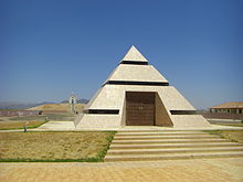 The pyramid houses the official center point.
 -
 Entrance to Center of the World Plaza


References[edit]
- ^ a b c U.S. Geological Survey Geographic Names Information System: Felicity, California
- ^ a b Anton, Mike (April 16, 2008). "See it now: the center of the world; The History of Humanity is being etched in stone in the California desert. The real story is the builder". Los Angeles Times. Archived from the original on January 27, 2013. Retrieved January 18, 2021.
- ^ a b Mooallem, Jon (February 19, 2014). "A Journey to the Center of the World". The New York Times Magazine. Archived from the original on September 3, 2014. Retrieved January 17, 2021.
{{cite news}}: CS1 maint: unfit URL (link) - ^ a b Burke, Anne (2 January 2019). "A strange museum at the 'centre of the world'". BBC. Archived from the original on 6 January 2019.
- ^ "Camp Pilot Knob, California". Desert Training Center. Retrieved January 17, 2021.
External links[edit]
- Roadside America article
- The church on the hill at Felicity
- A strange museum at the centre of the world
Municipalities and communities of Imperial County, California, United States | ||
|---|---|---|
| Cities |  | |
| CDPs | ||
| Unincorporated communities | ||
| Indian reservations | ||
| Ghost towns | ||
| Footnotes | ‡This populated place also has portions in an adjacent county or counties | |