
Bras d'Or Lake: Difference between revisions
Cornellier (talk | contribs) →Toponym: update with folk etymology |
m →Geography: Expand acronym "ppt" to "parts per thousand" to avoid ambiguity with "parts per trillion". |
||
| Line 43: | Line 43: | ||
The western side is generally shallow,<ref name="mnh">{{cite web |title=Bras d'Or Lake |url=https://web.archive.org/web/20060128223230/http://museum.gov.ns.ca/mnh/nature/nhns2/900/916.htm |website=web.archive.org |publisher=Nova Scotia Museum of Natural History |access-date=1 August 2021 |date=28 January 2006}}</ref> and is part of an extensive [[drumlin]] field. Steep hills rise abruptly on the northwestern side, to the [[Cape Breton Highlands]].<ref>{{cite web|title=Bras d'Or Lake|url=http://www.unesco.org/new/en/natural-sciences/environment/ecological-sciences/biosphere-reserves/europe-north-america/canada/bras-dor-lake|access-date=1 August 2021|website=www.unesco.org|publisher=United Nations Educational, Scientific and Cultural Organization}}</ref> |
The western side is generally shallow,<ref name="mnh">{{cite web |title=Bras d'Or Lake |url=https://web.archive.org/web/20060128223230/http://museum.gov.ns.ca/mnh/nature/nhns2/900/916.htm |website=web.archive.org |publisher=Nova Scotia Museum of Natural History |access-date=1 August 2021 |date=28 January 2006}}</ref> and is part of an extensive [[drumlin]] field. Steep hills rise abruptly on the northwestern side, to the [[Cape Breton Highlands]].<ref>{{cite web|title=Bras d'Or Lake|url=http://www.unesco.org/new/en/natural-sciences/environment/ecological-sciences/biosphere-reserves/europe-north-america/canada/bras-dor-lake|access-date=1 August 2021|website=www.unesco.org|publisher=United Nations Educational, Scientific and Cultural Organization}}</ref> |
||
The Denys, [[Middle River, Nova Scotia|Middle]], [[Baddeck River|Baddeck]], and [[Georges River, Nova Scotia|Georges]] Rivers all empty into the lake. The lake water has lower [[salinity]] than the surrounding ocean, and varies from about 20 parts per thousand near river mouths to 29 |
The Denys, [[Middle River, Nova Scotia|Middle]], [[Baddeck River|Baddeck]], and [[Georges River, Nova Scotia|Georges]] Rivers all empty into the lake. The lake water has lower [[salinity]] than the surrounding ocean, and varies from about 20 parts per thousand near river mouths to 29 parts per thousand in deeper areas.<ref name="mnh"/> |
||
Ice cover has been declining in recent years.<ref>{{cite web |title=Historical Total Accumulated Ice Coverage |url=https://ice-glaces.ec.gc.ca/prods/CVCHACTEC/20210308180000_CVCHACTEC_0011490963.pdf |publisher=Environment Canada |access-date=1 August 2021}}</ref> |
Ice cover has been declining in recent years.<ref>{{cite web |title=Historical Total Accumulated Ice Coverage |url=https://ice-glaces.ec.gc.ca/prods/CVCHACTEC/20210308180000_CVCHACTEC_0011490963.pdf |publisher=Environment Canada |access-date=1 August 2021}}</ref> |
||
Revision as of 14:55, 17 September 2021
| Bras d'Or Lake | |
|---|---|
 Bras d'Or Lake | |
| Location | Cape Breton Island, Nova Scotia |
| Coordinates | 45°51′37″N 60°46′44″W / 45.86028°N 60.77889°W |
| Type | estuary |
| Primary outflows | Gulf of St. Lawrence Atlantic Ocean |
| Basin countries | Canada |
| Max. length | 100 kilometres (62 mi) |
| Max. width | 50 kilometres (31 mi) |
| Surface area | 1,099 km2 (424 sq mi) |
| Max. depth | 287 m (942 ft) |
| Water volume | 32,000,000,000 m3 (4.2×10¹⁰ cu yd)[1] |
| Shore length1 | 1,000 kilometres (621 mi) (excluding islands)[1] |
| Surface elevation | 0 metres (0 ft) (sea level) |
| 1 Shore length is not a well-defined measure. | |
Bras d'Or Lake is an irregular estuary in the centre of Cape Breton Island in Nova Scotia, Canada.[2] It has a connection to the open sea, and is tidal. It also has inflows of fresh water from rivers, making the brackish water a very productive natural habitat. It was designated the Bras d'Or Lake Biosphere Reserve by UNESCO in 2011.[3]
Toponym
Pronounced (/brəˈdɔːr/ brə-DOR[4] or /bræˈdɔːr/ brad-OR),[5] maps before 1872 name it Le Lac de Labrador (or more simply Labrador).[6][7] Labrador was the name given by the Portuguese to much of eastern Canada. It meant farm, and is cognate with laborer.[8] An error of folk etymology, the name is spelt to resemble the French language Arm of Gold, a homonym. It is also called locally The Bras d'Or Lakes.
Geography

The lake has a surface area of 1099 square kilometers.[9] Three arms stretch out to the north east. At the top, the Great Bras d'Or Channel connects to the ocean via a navigable channel. The maximum depth is 287 metres (942 ft) in the East Bay. It sits in 3,500 square kilometer drainage basin.[10]
The western side is generally shallow,[11] and is part of an extensive drumlin field. Steep hills rise abruptly on the northwestern side, to the Cape Breton Highlands.[12]
The Denys, Middle, Baddeck, and Georges Rivers all empty into the lake. The lake water has lower salinity than the surrounding ocean, and varies from about 20 parts per thousand near river mouths to 29 parts per thousand in deeper areas.[11]
Ice cover has been declining in recent years.[13]
The lake is connected to the North Atlantic by two natural channels; the Great and Little Bras d'Or Channels which pass on either side of Boularderie Island.[14] The southern tip of the lake is connected to the Atlantic Ocean via the St. Peters Canal, built for shipping traffic in the 1860s.
The restricted channels to the ocean cause a reduction in tidal range.[11]
Seaweed populations resemble those found in the Gulf of St. Lawrence. The warm waters are suitable for eastern oyster. Fish species include the blackspotted stickleback, white hake, blueback herring, Greenland cod, and introduced rainbow trout. These feed double-crested cormorants, bald eagles, and great blue herons.[11]
Human history
The Mi'kmaq were the first inhabitants following the end of the last ice age. They called it Pitupaq, meaning long salt water. A French trading post was built in 1650.[9] Alexander Graham Bell built an estate Beinn Bhreagh where he established a research laboratory, and used the lake to test man-carrying kites, airplanes and hydrofoil boats.
Most of the shore is undeveloped, but settlements include Baddeck, Eskasoni, Little Bras d'Or, St. Peter's, and Whycocomagh. Shoreline is under the jurisdiction of the Cape Breton Regional Municipality and the county municipalities of Inverness, Victoria, and Richmond.
Sailboat racing is a long tradition in the Bras d'Or, with events hosted by the Bras d'Or Yacht Club[15]
Today most economic activity around the lake is related to the services in the tertiary sector of the economy.[3]
See also
- Bras d'Or Lake Scenic Drive
- Chapel Island First Nation
- Barra Strait: a narrows in the middle of the lake, transversed by the Barra Strait Bridge and the Grand Narrows Bridge.
- St. Patricks Channel: an arm of the lake
Gallery
-
 West Bay in early summer
 -
 Ocean-going ships enter and exit the Bras d'Or Lake system via Great Bras d'Or, spanned by the Seal Island Bridge
 -
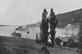 Passenger steamer on Bras d'Or Lake near New Campbellton, ca 1903.
 -
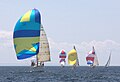 The East Bay Regatta, held the last weekend in July since 1984, features races and other social events. As many as 40 boats participate.

_Bridge_(cropped).jpg)


References
- ^ a b "Canadian Technical Report of Hydrography and Ocean Sciences 230 – Modelling the tides of the Bras d'Or Lakes" (PDF). Department of Fisheries and Oceans – 2003.
- ^ Chisholm, Hugh, ed. (1911). . Encyclopædia Britannica (11th ed.). Cambridge University Press.
- ^ a b "UNESCO Biosphere". UNESCO.
- ^ The Canadian Press (2017), The Canadian Press Stylebook (18th ed.), Toronto: The Canadian Press
- ^ "Bras d'Or Lake". Merriam-Webster.com Dictionary.
- ^ "Carte du Canada ou de la Nouvelle France et des decouvertes que y ont ete faites. Dressee sur plusieurs observations et sur un grand nombre de relations imprimees ou manuscrites. Par Guillaume Del'Isle, Geographe de l'Academie Royale des Sciences. A Paris – David Rumsey Historical Map Collection (includes map)". Guillaume DeLisle, Quai de l'Horloge a l'Aigle d'Or, Paris, 1708. Retrieved 24 April 2012.
- ^ "A Chart of the Gulf of St. Laurence, Composed From A Great Number of Actual Surveys – David Rumsey Historical Map Collection (includes map)". Sayer and Bennett, London, 1708. Retrieved 24 April 2012.
- ^ "Bras d'Or Lake (C. B.)". Place-names of the province of Nova Scotia by Thomas J. Brown. Royal Print & Litho. in Halifax, N.S. 1922.
- ^ a b Francis, Daniel (2014). "Bras d'Or Lake". www.thecanadianencyclopedia.ca. The Canadian Encyclopedia. Retrieved 1 August 2021.
- ^ "The Bras d'Or Lakes". Bras d'Or Lakes CEPI. Retrieved 1 August 2021.
- ^ a b c d "Bras d'Or Lake". web.archive.org. Nova Scotia Museum of Natural History. 28 January 2006. Retrieved 1 August 2021.
- ^ "Bras d'Or Lake". www.unesco.org. United Nations Educational, Scientific and Cultural Organization. Retrieved 1 August 2021.
- ^ "Historical Total Accumulated Ice Coverage" (PDF). Environment Canada. Retrieved 1 August 2021.
- ^ "Bras d'Or Lake". Encyclopedia Britannica. Retrieved 1 August 2021.
- ^ "Archived copy" (PDF). Archived from the original (PDF) on 4 March 2016. Retrieved 22 November 2015.
{{cite web}}: CS1 maint: archived copy as title (link)
External links
"Cruisers' guide to the Brad d'Or Lakes and Coastal Harbours"