Turan Depression: Difference between revisions
m →top: Autowikibrowser cleanup, typo(s) fixed: southeast-north → southeast–north |
Sheila1988 (talk | contribs) or |
||
| Line 1: | Line 1: | ||
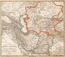
[[File:Iran Turan map 1843.jpg|thumb|Turan Depression (area enclosed by orange line)]] |
|||
The '''Turan Depression''', '''Turan Lowland''' or '''Turanian Basin''' is a [[lowland|low-lying]] [[desert]] [[Depression (geology)|basin]] region stretching from southern [[Turkmenistan]] through [[Uzbekistan]] to [[Kazakhstan]]. The [[lowland]] region lies to the east of the [[Caspian Sea]] and southeast of the [[Aral Sea]] in the vast [[Aral–Caspian Depression]] but extends to parts above sea level as well. It is one of the largest expanses of sand in the world.<ref>{{Cite book|last=Caroe|first=Olaf|url=http://worldcat.org/oclc/862273470|title=Soviet Empire : The Turks of Central Asia and Stalinism|date=1953|publisher=Macmillan|chapter=The Turanian Basin|oclc=862273470}}</ref> On average, the region receives less than 15 inches (381mm) of [[rainfall]] per year. The [[Karakum Desert|Karakum]] desert lies at the southern portion of the Turan Lowlands. |
The '''Turan Depression''', '''Turan Lowland''' or '''Turanian Basin''' is a [[lowland|low-lying]] [[desert]] [[Depression (geology)|basin]] region stretching from southern [[Turkmenistan]] through [[Uzbekistan]] to [[Kazakhstan]]. The [[lowland]] region lies to the east of the [[Caspian Sea]] and southeast of the [[Aral Sea]] in the vast [[Aral–Caspian Depression]] but extends to parts above sea level as well. It is one of the largest expanses of sand in the world.<ref>{{Cite book|last=Caroe|first=Olaf|url=http://worldcat.org/oclc/862273470|title=Soviet Empire : The Turks of Central Asia and Stalinism|date=1953|publisher=Macmillan|chapter=The Turanian Basin|oclc=862273470}}</ref> On average, the region receives less than 15 inches (381mm) of [[rainfall]] per year. The [[Karakum Desert|Karakum]] desert lies at the southern portion of the Turan Lowlands. |
||
Revision as of 22:30, 20 February 2022

The Turan Depression, Turan Lowland or Turanian Basin is a low-lying desert basin region stretching from southern Turkmenistan through Uzbekistan to Kazakhstan. The lowland region lies to the east of the Caspian Sea and southeast of the Aral Sea in the vast Aral–Caspian Depression but extends to parts above sea level as well. It is one of the largest expanses of sand in the world.[1] On average, the region receives less than 15 inches (381mm) of rainfall per year. The Karakum desert lies at the southern portion of the Turan Lowlands.
Three of the largest cities in the Turan Depression are Daşoguz in Turkmenistan, Nukus in Uzbekistan, and Urganch, also in Uzbekistan. Vpadina Akchanaya in Turkmenistan is 267 feet (81 meters) below sea level. The Amu Darya River runs in a southeast–north-westerly direction through the lowlands.
See also
References
- ^ Caroe, Olaf (1953). "The Turanian Basin". Soviet Empire : The Turks of Central Asia and Stalinism. Macmillan. OCLC 862273470.
41°50′00″N 59°58′00″E / 41.8333°N 59.9667°E
