Teavaro: Difference between revisions
Appearance
Content deleted Content added
infobox, population, reference |
mNo edit summary |
||
| Line 13: | Line 13: | ||
|elevation min m = |
|elevation min m = |
||
|elevation max m = |
|elevation max m = |
||
|area km2 = |
|||
|population = 2585 |
|population = 2585 |
||
|population date = 2022 |
|population date = 2022 |
||
Latest revision as of 14:35, 21 May 2024
Te'avaro | |
|---|---|
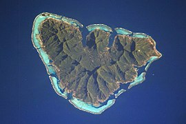
 Moʻorea, the island on which Te'avaro is located | |
Location within French Polynesia | |
| Coordinates: 17°30′28″S 149°46′12″W / 17.50778°S 149.77000°W | |
| Country | France |
| Overseas collectivity | French Polynesia |
| Subdivision | Windward Islands |
| Commune | Moʻorea-Maiʻao |
| Population (2022)[1] | 2,585 |
| Time zone | UTC−10:00 |
| Elevation | 6 m (20 ft) |
Te'avaro is an associated commune on the island of Mo'orea, in French Polynesia. It is part of the commune Moʻorea-Maiʻao. According to the 2022 census, it had a population of 2,585.[1]
References
[edit]- ^ a b "Les résultats du recensement de la population 2022 de Polynésie française" [Results of the 2022 population census of French Polynesia] (PDF) (in French). Institut de la statistique de la Polynésie française. January 2023.


