
Bonpara: Difference between revisions
→Bonpara Pourashava: A Glimpse at a Glance: move ref out of heading |
|||
| Line 6: | Line 6: | ||
Bonpara was incorporated as a municipality on December 31, 2002.<ref name=":1" /> |
Bonpara was incorporated as a municipality on December 31, 2002.<ref name=":1" /> |
||
== Bonpara Pourashava: A Glimpse at a Glance |
== Bonpara Pourashava: A Glimpse at a Glance == |
||
{| class="wikitable" |
{| class="wikitable" |
||
!Particular |
!Particular<ref name=":0" /> |
||
!Details |
!Details |
||
|- |
|- |
||
Latest revision as of 15:48, 22 June 2024
Bonpara is a paurashava (municipal corporation) in Baraigram Upazila of Natore District in north-western Bangladesh. It has a total population of around 22867.[1][2][3]
History[edit]
Catholic Christian missionaries in the Bhawal region cleared the woods and founded human settlements in the late 1920s. Because of the abundance of woods, it is called Bonpara. Initially, only Christians lived in this neighborhood, but other faiths eventually moved in. At the moment, all faiths may be found here. Bonpara was incorporated as a municipality on December 31, 2002.[2]
Bonpara Pourashava: A Glimpse at a Glance[edit]
| Particular[3] | Details |
|---|---|
| Established | 31/12/2002 |
| Category | "B" Category |
| Area | 6.92 sq km |
| Number of Wards | 9 |
| Total Population | 22,867 |
| Male | 11,375 |
| Female | 11,492 |
| Total Voter | 13,853 |
| Male | 6,627 |
| Female | 6,989 |
| Literacy Rate | 74% |
| Birth Registration Rate | 100% |
| Sanitation Rate | 100% |
| Employed | 26% |
| Businessmen and Others | 29% |
| Agriculturists | 45% |
| Birth Rate | 1.67% |
| Death Rate | 0.84% |
Educational Institutions[edit]
| Type | Number |
|---|---|
| Colleges/Universities | 2 |
| Higher Secondary Schools | 3 |
| Technical Colleges | 1 |
| Government Primary Schools | 4 |
| Non-Government Primary Schools | 3 |
| Madrasahs | 9 |
Religious Institutions[edit]
| Type | Number |
|---|---|
| Mosques | 27 |
| Temples | 7 |
| Churches | 2 |
| Graveyards | 11 |
| Crematoriums | 3 |
| Eidgah | 12 |
Other Institutions[edit]
| Type | Number |
|---|---|
| Upazila Parishad | 1 |
| Highway Thana | 1 |
| Police Investigation Center | 1 |
| Non-Government Hospitals | 5 |
| Charitable/Mission Hospitals | 1 |
| Petrol Pumps | 1 |
| NGOs | 7 |
| Telephone Exchanges | 1 |
| Auto Rice Mills | 1 |
| Chicken Feed Mills | 1 |
| Rice Mills | 26 |
| Sawmills | 14 |
| Shaheed Dr. Ayonul Haque Foundation | 1 |
Roads and Drains[edit]
| Type | Length (km) |
|---|---|
| RHD Roads | 8.4 |
| Unpaved Roads | 77 |
| Paved Roads | 6.10 |
| Semi-paved Roads | 10.50 |
| Total Roads | 102 |
| Unpaved Drains | 1.670 |
| Paved Drains | 0.330 |
| Total | 2.00 |
Holding Numbers[edit]
| Type | Number |
|---|---|
| Municipal Holdings | 4,881 |
| Government Holdings | 16 |
| Residential Holdings | 4,400 |
| Commercial Holdings | 445 |
| Cultivated Land Area | 1,384 acres |
| Uncultivated Land Area | 913 acres |
| Municipal Land Ownership: | 41% |
Markets and Utilities[edit]
| Type | Number |
|---|---|
| Markets | 1 |
| Municipal Supplied Tubewells | 92 |
Staff and Employees[edit]
| Type | Number |
|---|---|
| Permanent | 22 |
| Temporary | 2 |
| Community Police | 3 |
| Cleaning Staff | 5 |
| Banks/Insurance | 8 |
| Christian Mission | 1 |
| Non-Government Markets | 13 |
| Residential Hotels | 1 |
| Ponds | 32 |
| River (Canal) | 1 |
Baraigram Upazila Chairman Murder[edit]
Sanaullah Noor Babu, the chairman of Baraigram upazila, was murdered on October 8, 2010.[4]
Sunil Gomes murder[edit]
On Oct. 5, Sunil Gomes was killed at his grocery store.[5]
Photo gallery[edit]
-
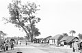 Bonpara bazar, 1965
 -
 Church of Our Lady of Lourdes, Bonpara, 1965
 -
 St Josephs High School, Bonpara, 1965
 -
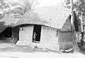 "Kacha ghor" bedroom hut in Bonpara, 1966
 -
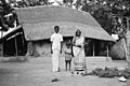 Young couple at home, 1966
 -
 Traditional wall decoration, Bonpara, 1966


References[edit]
- ^ "Community Report: Natore" (PDF). Population & Housing Census 2011. Bangladesh Bureau of Statistics. Retrieved 2019-06-19.
- ^ a b "Bonpara - Bangladesh". Retrieved 7 June 2016.
- ^ a b "বনপাড়া পৌরসভা". Baraigram Upazila. Retrieved 2024-05-09.
- ^ Staff Correspondent; Rajshahi (2010-10-09). "Boraigram upazila chairman killed". The Daily Star. Retrieved 2022-08-16.
- ^ Dhaka, Agence France-Presse in (5 June 2016). "Christian murdered in latest Bangladesh attack". The Guardian. Retrieved 7 June 2016.
24°17′25″N 89°04′55″E / 24.2904°N 89.0820°E
This Rajshahi Division location article is a stub. You can help Wikipedia by expanding it. |