
Engelstadt: Difference between revisions
m WP:CHECKWIKI error fixes using AWB (9075) |
|||
| Line 23: | Line 23: | ||
==Geography== |
==Geography== |
||
===Location=== |
===Location=== |
||
The municipality lies southwest of [[Mainz]] and is an agriculturally oriented community. The [[winegrowing]] centre belongs to the [[Gau-Algesheim (Verbandsgemeinde)|''Verbandsgemeinde'' of Gau-Algesheim]], whose seat is in the [[Gau-Algesheim|like-named town]]. |
The municipality lies southwest of [[Mainz]] and is an agriculturally oriented community. The [[winegrowing]] centre belongs to the [[Gau-Algesheim (Verbandsgemeinde)|''Verbandsgemeinde'' of Gau-Algesheim]], whose seat is in the [[Gau-Algesheim|like-named town]]. |
||
| Line 30: | Line 31: | ||
==Politics== |
==Politics== |
||
===Municipal council=== |
===Municipal council=== |
||
===Town council=== |
===Town council=== |
||
The council is made up of 12 council members who were elected on 13 June 2004 by [[Plurality voting system|majority vote]]. |
The council is made up of 12 council members who were elected on 13 June 2004 by [[Plurality voting system|majority vote]]. |
||
| Line 38: | Line 41: | ||
==Culture and sightseeing== |
==Culture and sightseeing== |
||
===Buildings=== |
===Buildings=== |
||
[[File:Engelstadt Evangelische Kirche 20100902.jpg|thumb|hochkant|Evangelical parish church Saint Maurice]] |
[[File:Engelstadt Evangelische Kirche 20100902.jpg|thumb|hochkant|Evangelical parish church Saint Maurice]] |
||
| Line 48: | Line 52: | ||
==Economy and infrastructure== |
==Economy and infrastructure== |
||
===Transport=== |
===Transport=== |
||
The municipality is crossed by ''[[Kreisstraße]]'' 16. The [[Bundesautobahn 60|A 60]] and [[Bundesautobahn 63|A 63]] [[autobahn]]s can be reached by car in 10 to 20 minutes. |
The municipality is crossed by ''[[Kreisstraße]]'' 16. The [[Bundesautobahn 60|A 60]] and [[Bundesautobahn 63|A 63]] [[autobahn]]s can be reached by car in 10 to 20 minutes. |
||
Revision as of 09:26, 9 April 2013
Engelstadt | |
|---|---|
 Coat of arms | |
Location of Engelstadt within Mainz-Bingen district 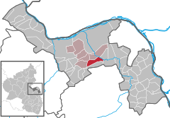 | |
| Country | Germany |
| State | Rhineland-Palatinate |
| District | Mainz-Bingen |
| Municipal assoc. | Gau-Algesheim |
| Government | |
| • Mayor | Heike Zieren-Hesse |
| Area | |
| • Total | 7.76 km2 (3.00 sq mi) |
| Elevation | 214 m (702 ft) |
| Population (2022-12-31)[1] | |
| • Total | 730 |
| • Density | 94/km2 (240/sq mi) |
| Time zone | UTC+01:00 (CET) |
| • Summer (DST) | UTC+02:00 (CEST) |
| Postal codes | 55270 |
| Dialling codes | 06130 |
| Vehicle registration | MZ |
| Website | www.engelstadt.de |
Engelstadt is an Ortsgemeinde – a municipality belonging to a Verbandsgemeinde, a kind of collective municipality – in the Mainz-Bingen district in Rhineland-Palatinate, Germany.
Geography
Location
The municipality lies southwest of Mainz and is an agriculturally oriented community. The winegrowing centre belongs to the Verbandsgemeinde of Gau-Algesheim, whose seat is in the like-named town.
History
In 941, Engelstadt had its first documentary mention as Engilestat.
Politics
Municipal council
Town council
The council is made up of 12 council members who were elected on 13 June 2004 by majority vote.
Coat of arms
The municipality’s arms might be described thus: Azure an angel proper wings expanded, in his hand dexter a bunch of grapes slipped vert, in base sinister a church tower Or ensigned with a cross.
Culture and sightseeing
Buildings

The Evangelical parish church had its first documentary mention in 1228 and is consecrated to Saint Maurice. Especially valuable is the Carolingian door lintel in the tower. The church houses an organ built in 1855 by Hermann Dreymann (Mainz).
Regular events
The Engelstadt kermis (church consecration festival, locally known as the Kerb) is held yearly on the second weekend in September and the village festival on the first weekend in July.
Furthermore there has been in Engelstadt since 2003 the Rockhexennacht (“Rock Witches’ Night”). This is a live, outdoor concert with rock music held yearly on 30 April by the Engelstadt Cycling Club and the Engelstadt Youth Club.
Economy and infrastructure
Transport
The municipality is crossed by Kreisstraße 16. The A 60 and A 63 autobahns can be reached by car in 10 to 20 minutes.
Education
- Municipal kindergarten
References
- ^ "Bevölkerungsstand 2022, Kreise, Gemeinden, Verbandsgemeinden" (PDF) (in German). Statistisches Landesamt Rheinland-Pfalz. 2023.
External links

This Mainz-Bingen location article is a stub. You can help Wikipedia by expanding it. |