Lanthes: Difference between revisions
Appearance
Content deleted Content added
mNo edit summary |
ibx param |
||
| Line 1: | Line 1: | ||
{{Infobox French commune |
{{Infobox French commune |
||
|name = Lanthes |
|name = Lanthes |
||
|commune status = [[Communes of France|Commune]] |
|||
|image = Lanthes 2013 03 04 03.jpg |
|image = Lanthes 2013 03 04 03.jpg |
||
|image coat of arms = Blason de la ville de Lanthes (Côte-d'Or).svg |
|image coat of arms = Blason de la ville de Lanthes (Côte-d'Or).svg |
||
Revision as of 04:25, 16 June 2017
Lanthes | |
|---|---|
 | |
| Coordinates: 46°59′40″N 5°12′16″E / 46.9944°N 5.2044°E | |
| Country | France |
| Region | Bourgogne-Franche-Comté |
| Department | Côte-d'Or |
| Arrondissement | Beaune |
| Canton | Brazey-en-Plaine |
| Intercommunality | Rives de Saône |
| Government | |
| • Mayor (2008–2014) | Yves Minet |
| Area 1 | 9.79 km2 (3.78 sq mi) |
| Population (2008) | 244 |
| • Density | 25/km2 (65/sq mi) |
| Time zone | UTC+01:00 (CET) |
| • Summer (DST) | UTC+02:00 (CEST) |
| INSEE/Postal code | 21340 /21250 |
| Elevation | 184–194 m (604–636 ft) (avg. 180 m or 590 ft) |
| 1 French Land Register data, which excludes lakes, ponds, glaciers > 1 km2 (0.386 sq mi or 247 acres) and river estuaries. | |
You can help expand this article with text translated from the corresponding article in French. (January 2009) Click [show] for important translation instructions.
|
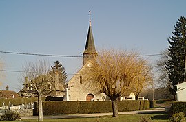
Lanthes is a commune in the Côte-d'Or department in eastern France.
Population
| Year | Pop. | ±% |
|---|---|---|
| 1962 | 95 | — |
| 1968 | 134 | +41.1% |
| 1975 | 110 | −17.9% |
| 1982 | 188 | +70.9% |
| 1990 | 204 | +8.5% |
| 1999 | 180 | −11.8% |
| 2008 | 244 | +35.6% |
See also
References
Wikimedia Commons has media related to Lanthes.


