(Translated by https://www.hiragana.jp/)
Conder Bridge - Wikipedia Jump to content

Conder Bridge

Coordinates: 53°59′42″N 2°49′33″W / 53.994863°N 2.82580797°W / 53.994863; -2.82580797
From Wikipedia, the free encyclopedia

This is an old revision of this page, as edited by Seasider53 (talk | contribs) at 17:42, 16 November 2021 (Created page with '{{Short description|Bridge at Conder Green, England}} {{Use dmy dates|date=November 2021}} {{Use British English|date=November 2021}} {{Infobox Bridge | bridge_name = Conder Bridge | image = File:Conder Bridge, Conder Green - geograph.org.uk - 1068328.jpg | caption = The bridge in 2008, looking northwest | official_name = | carries = A588 | crosses = River Conder | locale = Conder Green, Thurnha...'). The present address (URL) is a permanent link to this revision, which may differ significantly from the current revision.

(diff) ← Previous revision | Latest revision (diff) | Newer revision → (diff)

Conder Bridge
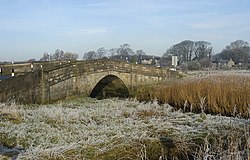
The bridge in 2008, looking northwest
Coordinates53°59′42″N 2°49′33″W / 53.994863°N 2.82580797°W / 53.994863; -2.82580797
CarriesA588
CrossesRiver Conder
LocaleConder Green, Thurnham, Lancashire, England
History
OpenedEarly 19th century
Location
Map

Conder Bridge is a Grade II listed single-segemental-arch bridge spanning the River Conder in the English village of Conder Green, Thurnham, Lancashire. The structure dates to the early 19th century.[1] The bridge carries the vehicular and pedestrian traffic of the A588.

The bridge is flanked by piers, with abutments also punctuated by piers. It has a solid parapet with a string course and weathered coping.[1]

See also

References

  1. ^ a b "Conder Bridge". Historic England. Retrieved 15 November 2021.