Moone
Moone
Maoin | |
|---|---|
Village | |
 Main street | |
| Coordinates: 52°59′N 6°49′W / 52.983°N 6.817°W | |
| Country | Ireland |
| Province | Leinster |
| County | County Kildare |
| Elevation | 107 m (351 ft) |
| Population (2016)[1] | 487 |
| Time zone | UTC±0 (WET) |
| • Summer (DST) | UTC+1 (IST) |
| Eircode routing key | R14 |
| Telephone area code | 059 |
| Irish Grid Reference | S795931 |
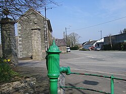
Moone (/ˈmuːn/; Irish: Maoin or Maen Colmcille, meaning 'Colmcille's property')[2] is a small village in the south of County Kildare, Ireland. It is on the former N9 road (now by-passed) about 80 km (50 mi) south of Dublin. It has only a few hundred inhabitants, a church, a national school, one shop and a small community centre. There is also pub called the Moone High Cross Inn.[3] The village is in a townland and civil parish of the same name.[2]
Etymology
[edit]The name Moone comes from the Irish "Maen Colmcille" which means "Colmcille's property".[citation needed]
Location, access and development
[edit]The closest village to Moone is Timolin, less than 1 kilometre to the north, and a number of Kildare County Council development plans have provided for joint development of Moone and Timolin.[4]
The village is served by bus route 880 operated by Kildare Local Link. There are several buses each day including Sunday linking the village to Castledermot, Carlow and Naas as well as villages in the area.[5]
High Cross
[edit]

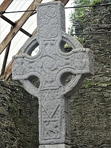
Moone's most notable landmark is its high cross, dating from the 8th century.[6] It is located approximately 1 kilometre from Moone along the road to Athy (at 52°58′48″N 6°49′31″W / 52.98000°N 6.82528°W). It stands in the remains of an old abbey which has been associated with Saint Colmcille and whose church is believed to have been built by the Franciscans around 1300.[7]
Bolton Abbey - Cistercian Monastery
[edit]Bolton Abbey, Moone, County Kildare, was established in 1965 by monks from Mount St. Joseph Abbey, Roscrea, in 1977 it became an independent monastery, in 2015 it celebrated its 50 anniversary.[8]
Sport
[edit]The National Hunt trainer Jessica Harrington has her stables at Moone. Her most successful horses have included Moscow Flyer, Macs Joy, Jezki, Sizing John and Alpha Centauri.
There is a local soccer club called Moone Celtic FC. The club's crest includes a high cross, and its pitch is Fortfield Park on the old N9 to Carlow.
See also
[edit]- Ireland's Vanishing Triangle
- List of towns and villages in Ireland.
- List of abbeys and priories in Ireland (County Kildare)
References
[edit]- ^ "Census 2016: Kildare's Population Change, by Electoral District. | KFM Radio". Archived from the original on 2 October 2019. Retrieved 8 November 2020.
- ^ a b "Maoin / Moone (see archival records)". logainm.ie. Irish Placenames Commission. Retrieved 10 January 2020.
- ^ County Kildare: Moone
- ^ "Local Area Plan / November 2002 - Ballitore, Crookstown, Timolin And Moone". kildare.ie. Kildare County Council. Retrieved 10 January 2020.
- ^ "Locals Encouraged to Use New Bus Route Serving Villages from Castledermot to Kilcullen". 14 August 2015.
- ^ "County Kildare - Moone High Cross".
- ^ Local Area Plan - November 2002 - Moone (PDF). kildare.ie (Report). Kildare County Council. November 2002. p. 13. Retrieved 10 January 2020.
The High Cross of Moone is one of the two tallest High Crosses in the Country and [..] is located on the site of an early Christian monastery and within the remains of a church, possibly built by the Franciscans around 1300
- ^ Bolton Abbey Official Website
External links
[edit]


