
Puchheim
Puchheim | |
|---|---|
 Coat of arms | |
Location of Puchheim within Fürstenfeldbruck district 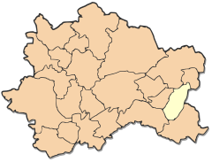 | |
| Country | Germany |
| State | Bavaria |
| Admin. region | Oberbayern |
| District | Fürstenfeldbruck |
| Subdivisions | 2 Ortsteile |
| Government | |
| • Mayor | Dr. Herbert Kränzlein (SPD) |
| Area | |
| • Total | 12.23 km2 (4.72 sq mi) |
| Elevation | 535 m (1,755 ft) |
| Population (2022-12-31)[1] | |
| • Total | 21,420 |
| • Density | 1,800/km2 (4,500/sq mi) |
| Time zone | UTC+01:00 (CET) |
| • Summer (DST) | UTC+02:00 (CEST) |
| Postal codes | 82178 |
| Dialling codes | 089 |
| Vehicle registration | FFB |
| Website | www.puchheim.de |
Puchheim is a municipality near Munich in the district of Fürstenfeldbruck, in Bavaria, Germany. It has about 20,000 inhabitants, and is located at 48°09′N 11°21′E / 48.150°N 11.350°E. Puchheim is divided into two parts: the old and rural part called Puchheim-Ort and the new part of Puchheim (Puchheim Bahnhof) that was founded when the S-Bahn (a quick train commuting to Munich) was built. Before that there was a big prison camp. The area around the camp was dried up by workers from the prison camp, so that houses could be built.
The old part of Puchheim is even older than Munich.
Puchheim is well connected to the regional and national traffic network by S-Bahn ![]() (S8) and Autobahn (A 8, A 99)
(S8) and Autobahn (A 8, A 99)
Towns and municipalities in Fürstenfeldbruck district | ||
|---|---|---|
This Fürstenfeldbruck district location article is a stub. You can help Wikipedia by expanding it. |
- ^ Genesis Online-Datenbank des Bayerischen Landesamtes für Statistik Tabelle 12411-003r Fortschreibung des Bevölkerungsstandes: Gemeinden, Stichtag (Einwohnerzahlen auf Grundlage des Zensus 2011).