
Mogilev
53°54′N 30°20′E / 53.900°N 30.333°E
Mogilev
Mahilyow Mahilioŭ Магілёў Могилёв | |
|---|---|
 Mogilev in winter | |
 Flag  Coat of arms | |
| Country Subdivision | Mogilev Region |
| Founded | 1267 |
| Government | |
| • Mayor | Stanislaw Baradawka |
| Area | |
| • Total | 118.50 km2 (45.75 sq mi) |
| Elevation | 192 m (630 ft) |
| Population (2009) | |
| • Total | 360,918 |
| • Density | 3,000/km2 (7,900/sq mi) |
| Time zone | UTC+3 |
| Postal code | 212 001 |
| Area code | +375 222 |
| License plate | 6 |
| Website | Official website |
Mogilev (officially transliterated as Mahilioŭ?, also spelled Mahiloŭ?, Mahilyow, Mogilyov; Belarusian: Магілёў, pronounced [maɣʲiˈlʲou̯]; Russian: Могилёв, pronounced [məɡʲɪˈlʲof]) is a city in eastern Belarus, about 76 kilometres (47 miles) from the border with Russia's Smolensk Oblast and 105 km (65 miles) from the border with Russia's Bryansk Oblast. As of 2011, its population was 360,918.,[2] up from an estimated 106,000 in 1956. It is the administrative centre of Mogilev Region and the third largest city in Belarus.
Outline of History

The city is mentioned in historical sources since 1267. From the 14th century it was part of the Grand Duchy of Lithuania, and, since the Union of Lublin (1569), part of the Polish-Lithuanian Commonwealth, where it became known as Mohylew or Mogilew. In 16th-17th century the city flourished as one of the main nodes of the east-west and north-south trading routes.
In 1577 Polish King Stefan Batory granted it with city rights under Magdeburg law. In 1654, the townsmen negotiated a treaty of surrender to the Russians peacefully, if the Jews were to be expelled and their property divided up among Mogilev's inhabitants. Tsar Aleksei Mikhailovitch agreed. However, instead of expelling the Jews, the Russian troops massacred them after they had led them to the outskirts of the town.[3] After the First Partition of Polish-Lithuanian Commonwealth (1772) it became part of the Russian Empire and became the centre of the Mogilev Governorate.
In the years 1915–1917, during World War I, the Stavka, the headquarters of the Russian Imperial Army was based in the city and the Tsar, Nicholas II, spent long periods there as Commander-in-Chief.
Following the Russian Revolution, in 1918, the city was briefly occupied by Germany and placed under their short-lived Belarusian People's Republic. Then, in 1919 it was captured by the forces of Soviet Russia and incorporated into the Byelorussian SSR. Up to the Second World War and the Holocaust, like many other cities in Europe, Mogilev had a significant Jewish population: according to the Russian census of 1897, out of the total population of 41,100, 21,500 were Jews (i.e. around 50% percent).[4]
Between 26 July 1941 and 28 June 1944 the city was under German occupation.[5] During that period, the Jews of Mogilev were ghettoized and systematically murdered.[6]
In 1944, the city returned to Soviet domination.
Since Belarus gained its independence in 1991 Mogilev has remained one of its principal cities.

Government and Governors
This section is empty. You can help by adding to it. (March 2013) |
Economy
From 1267 thru 1944...[clarification needed].
After World War II a huge metallurgy centre with several major steel mills was built. Also, several major factories of cranes, cars, tractors and a chemical plant were established. By the 1950s, tanning was its principal industry, and it was a major trading centre for cereal, leather, salt, sugar, fish, timber and flintstones: the city is home to a major inland port at the Dnieper river since (year/period) and a domestic airport since. Since the fall of the Soviet Union and the establishment of Byelorus as an independent country, Mogilev has become one of that country's main economic and industrial centres.
Main sights

The town's most striking landmark is the late 17th-century town hall. The grand tower of the town hall sustained serious damage during the Great Northern War and the Great Patriotic War. It was eventually demolished in 1957. The town hall was rebuilt in its pre-war form in 2008.
Another important landmark of Mogilev is the six-pillared St. Stanislaw's Cathedral, built in the Baroque style in 1738–52 and distinguished by its energetic murals. The convent of St. Nicholas, preserves its magnificent cathedral from 1668, as well as original iconostasis, belltower, walls, and gates. It is currently under consideration to become a UNESCO World Heritage site.[7]
Minor landmarks include the archiepiscopal palace and memorial arch, both dating from the 1780s, and the enormous theatre in the blend of the Neo-Renaissance and Russian Revival styles.
At Polykovichi, an urban part of Mogilev, there is a 350 metre tall guyed TV mast, one of the tallest structures in Belarus.
-

The Convent of St. Nicholas -

The Russian Orthodox church -
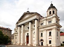
St. Stanislaw's Cathedral

.jpg)

| Climate data for Mogilev, Belarus | |||||||||||||
|---|---|---|---|---|---|---|---|---|---|---|---|---|---|
| Month | Jan | Feb | Mar | Apr | May | Jun | Jul | Aug | Sep | Oct | Nov | Dec | Year |
| Mean daily maximum °C (°F) | −3.0 (26.6) |
−2.5 (27.5) |
3.0 (37.4) |
12.0 (53.6) |
18.6 (65.5) |
21.5 (70.7) |
23.6 (74.5) |
22.7 (72.9) |
16.7 (62.1) |
9.9 (49.8) |
2.3 (36.1) |
−2.0 (28.4) |
10.2 (50.4) |
| Mean daily minimum °C (°F) | −7.8 (18.0) |
−8.5 (16.7) |
−4.2 (24.4) |
2 (36) |
7.3 (45.1) |
10.8 (51.4) |
12.7 (54.9) |
11.6 (52.9) |
7.1 (44.8) |
2.6 (36.7) |
−2.3 (27.9) |
−6.6 (20.1) |
2.1 (35.8) |
| Average precipitation mm (inches) | 43 (1.7) |
35 (1.4) |
39 (1.5) |
47 (1.9) |
59 (2.3) |
81 (3.2) |
86 (3.4) |
75 (3.0) |
57 (2.2) |
54 (2.1) |
51 (2.0) |
49 (1.9) |
676 (26.6) |
| Average precipitation days | 22 | 17 | 15 | 14 | 12 | 14 | 15 | 11 | 14 | 17 | 22 | 26 | 199 |
| Average relative humidity (%) | 86 | 84 | 81 | 74 | 68 | 71 | 74 | 75 | 80 | 84 | 88 | 89 | 80 |
| Source: [8] | |||||||||||||
Notable citizens
- Abe Anellis, microbiologist
- David Pinski, Yiddish playwright
- Irving Berlin, American composer
- Issai Schur, mathematician
- Leonid Isaakovich Mandelshtam, physicist
- Alyona Lanskaya, singer
- Lev Polugaevsky, International Grandmaster of chess
- Matest M. Agrest, ethnologist and mathematician
- Mikałaj Sudziłoŭski, revolutionary and scientist
- Modest Altschuler, orchestra conductor
- Otto Schmidt, scientist, mathematician, astronomer, geophysicist, statesman, academician
- Petr Elfimov, musician
- Spiridon Sobol, Belarusian enlightener and printer, in 1631 he published the first ABC-book in Belarus
- Andrey Melnikov, soldier and recipient of Hero of the Soviet Union award
Twin towns – Sister cities
Mahilyow is twinned with:
 Kragujevac, Serbia[9]
 Gabrovo, Bulgaria
 Villeurbanne, France
 Bardejov, Slovakia
 Eisenach, Germany
 Kerch, Ukraine
 Tula, Russia
 Klaipėda, Lithuania
 Włocławek, Poland
 Denizli, Turkey
 Shymkent, Kazakhstan
 Sumgait, Azerbaijan[10]
References
- ^ "Eternal Daylight Saving Time (DST) in Belarus". timeanddate.com. 19 September 2011. Retrieved 14 May 2013.
- ^ Ярковец, А.И. (2011). "Численность населения на 1 января 2011 года и среднегодовая численность населения за 2010 год по Республике Беларусь в разрезе областей, районов, городов, поселков городского типа". Официальный сайт Национального статистического комитета Республики Беларусь (in русский). Национальный статистический комитет Республики Беларусь. p. 21. Archived from the original (Статистический бюллетень) on 2012-02-04. Retrieved 2012-01-13.
{{cite web}}: CS1 maint: unrecognized language (link) - ^ Russia's First Modern Jews, NYU Press 1995, David Fishman, p.2
- ^ Joshua D. Zimmerman, Poles, Jews, and the politics of nationality, Univ of Wisconsin Press, 2004, ISBN 0-299-19464-7, Google Print, p.16
- ^ Mogilev The fate of the Jews under the German Invasion & Occupation
- ^ [1]
- ^ St. Nicholas Monastery Complex in the city of Mahilyou – UNESCO World Heritage Centre
- ^ "Weatherbase". Weatherbase. Retrieved December 9, 2012.
- ^ "Kragujevac Twin Cities". ©2009 Information service of Kragujevac City. Retrieved 2009-02-21.
- ^ "Sumqayıt şəhər icra hakimiyyəti. Beynəlxalq Əlaqələr". Retrieved 2010-12-29.
{{cite web}}: Unknown parameter|trans_title=ignored (|trans-title=suggested) (help)
External links
- Mogilev city executive committee
- Photos on Radzima.org
- Historic images of Mogilev
- Mogilev Jewish Center
- Jewish Encyclopedia on Moghilef (Mohilev)
City and regional maps of Mogilev
- Best zoomable map of Mogilev and Belarus available, possible to see Voblasts, Rajons, cities and streets -> In page click KAPTbI up in the middle
- Zoomable map of Mogilev and in general from Belarus
- zoomable map of Belarus with low resolution
- Good overview map of roads and railways
- General overview of Baltics, Belarus and east-europe
- Belarus, topographic map
- "Baltic countries full detail railway map. Belarus and Baltics in C1 sector". Archived from the original on 23 May 2012.
- General detail, downloadable PDF map of Belarus