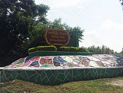
Nawnghkio
Nawnghkio
ဝဵင်းၼွင်ၶဵဝ် | |
|---|---|
Town | |
 | |
| Coordinates: 22°19′N 96°48′E / 22.317°N 96.800°E | |
| Country | |
| Division | |
| Population (2019)[1] | 16,274 |
| • Ethnicities | Shan Bamar |
| • Religions | Buddhism |
| Time zone | UTC+6.30 (MST) |
Nawnghkio (Burmese: နောင်ချိုမြို့, Shan: ဝဵင်းၼွင်ၶဵဝ်), variously spelt Naunghkio, Naungcho or Nawngcho, is a town in Kyaukme District, in northern Shan State, Burma. It is the principal town and administrative seat of Nawnghkio Township. It is connected to Mandalay, Pyin U Lwin, Kyaukme, Hsipaw and Lashio by road and rail and by road to Taunggyi via National Road 43.[2][3] Asia World Company won the contract to rebuild part of the road in 2002.[4] Originally on the Mandalay-Lashio Road, after Pyin U Lwin and before Kyaukme, Nawnghkio is on what is now the Mandalay-Muse Road, part of the Asian Highway Route 14 (AH14).[2]
Approximately 2,900 acres (12 km2) of land in the area were reclaimed and allotted to coffee growers in 1999–2000.[5]
Women of reproductive age (15-49) in Kyaukme and Nawnghkio have been targeted for improvement in reproductive health in the community in collaboration with Japan. A study mission was started in June 2004, with the project continuing for the period January 2005- December 2009.[6][7]
The town was seized by the Ta'ang National Liberation Army during fighting in June 2024 in the course of Myanmar's civil war.[8]
Notes
- ^ Myanmar Information Management Unit (September 2019). Theinni Myone Daethasaingyarachatlatmya သိန္နီမြို့နယ် ဒေသဆိုင်ရာအချက်လက်များ [Hsenwi Township Regional Information] (PDF) (Report). MIMU. Retrieved 17 October 2023.
- ^ a b "Asian Highway in Myanmar" (PDF). unescap.org. Retrieved 1 February 2009.
- ^ "Train travel in Myanmar(Burma)". seat61.com. Retrieved 1 February 2009.
- ^ "Road construction contract signed". New Light of Myanmar. 16 August 2002. Archived from the original on 8 November 2005. Retrieved 1 February 2009.
- ^ "Coffee: a promising export item" (PDF). New Light of Myanmar. 7 November 2003. Retrieved 1 February 2009.
- ^ "Preparation for the New Project on Reproductive Health with Community Initiative in Myanmar". Japanese Organization for International Cooperation in Family Planning (JOICFP). September 2004. Retrieved 24 March 2009.
- ^ Dr Kyee Myint. "Country Presentation:The 4th Asean & Japan High Level Officials Meeting on Caring Societies, 28.8.2006.to 31.8.2006" (PDF). Ministry of Health. Archived from the original (PDF) on 1 May 2011. Retrieved 24 March 2009.
- ^ "TNLA Seizes Town and Myanmar Regime Positions in Northern Shan State". The Irrawaddy. 26 June 2024.


