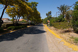
Olesh
Appearance
Olesh
עֹלֶשׁ | |
|---|---|
 | |
| Coordinates: 32°19′57″N 34°59′7″E / 32.33250°N 34.98528°E | |
| Country | Israel |
| District | Central |
| Council | Hefer Valley |
| Affiliation | Moshavim Movement |
| Founded | 1951 |
| Founded by | Romanian immigrants |
| Population (2022)[1] | 1,192 |
Olesh (Hebrew: עֹלֶשׁ, עולש, lit. 'Chicory') is a moshav in central Israel. Located in the Sharon plain, it falls under the jurisdiction of Hefer Valley Regional Council. In 2022 it had a population of 1,192.[1]
History
The moshav was founded in 1951 by immigrants from Romania on land south of the Palestinian village of Qaqun, which had been depopulated in the 1948 Arab–Israeli War.[2][3] It was initially named Be'erotayim Bet, but was later renamed Olesh due to the large chicory plants in the area.[4]
In 1953 it absorbed more immigrants from North Africa and in 1965 it took in new residents from Beit She'an. In the late 1990s it doubled in size as part of an expansion plan.[citation needed]
References
- ^ a b "Regional Statistics". Israel Central Bureau of Statistics. Retrieved 21 March 2024.
- ^ Morris, Benny (2004). The Birth of the Palestinian Refugee Problem Revisited. Cambridge: Cambridge University Press. pp. xxii, 248, 533. ISBN 978-0521009676.
- ^ Khalidi, Walid (1992). All That Remains: The Palestinian Villages Occupied and Depopulated by Israel in 1948. Washington D.C.: Institute for Palestine Studies. p. 560. ISBN 0-88728-224-5.
- ^ Olesh Homee

